Nearby
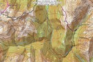
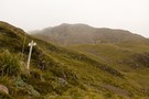
Paratu Stream - Waharoa Saddle
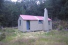
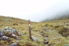
Pfeiffer Biv
Photograph
•
Distance: less than 100m away
cosy,dinky even,modern 2 bunker with longdrop nearby.
More ▶︎
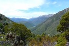
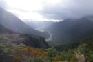
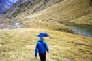
Lake Karaupataka
Photograph
•
Distance: less than 100m away
Lake Karaupataka From Waharoa Saddle
More ▶︎
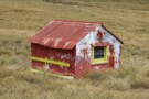
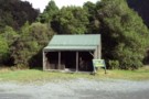
"Old" Pfeifer biv (Removed) Dec 2007
Photograph
•
Distance: less than 100m away
The old biv a few months before it was replaced.
More ▶︎
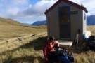
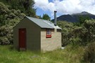
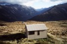
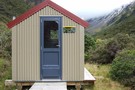
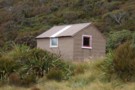
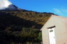
Pfeifer biv
Hut
•
Basic Hut/Bivvy (DOC). Capacity: 2.
•
Distance: less than 100m away
A new biv from early 2008 replacing an old biv that was about 20m to the south. (The sign on ...
More ▶︎
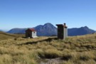
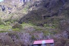
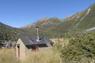
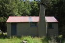
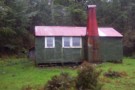
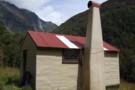
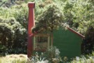
Pfeifer biv & toilet April 2012
Photograph
•
Distance: less than 100m away
A new biv from early 2008 replacing an old biv that was about 20m to the south. (The sign on ...
More ▶︎
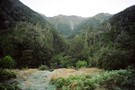
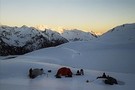
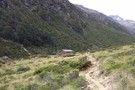
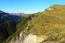
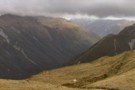
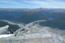
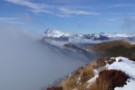
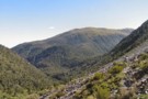
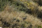
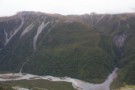
birds-eye view
Photograph
•
Distance: 146m away
Looking from Waharoa Saddle down Pfeifer Stream & to Lake Kaurapataka
More ▶︎
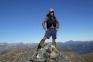
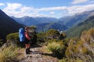
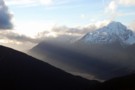
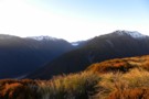
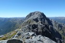
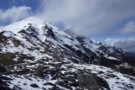
Posing on Mt Pfeifer
Photograph
•
Distance: 798m away
This pic looks westward from Mt Pfeifer during autumn conditions prior to the May snowfalls.
Mt Pfeifer is an easy ...
More ▶︎
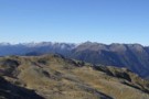
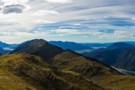
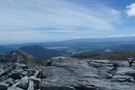
Mt Pfeifer etc from Kellys Hill July 2011
Photograph
•
Distance: 801m away
This photo was taken from near the broadcasting repeaters on top of Kellys Hill which is the hill immediately north ...
More ▶︎

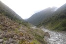
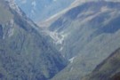
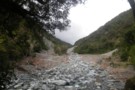
Descent from Pfeifer Biv into Pfeifer Creek via scree
Photograph
•
Distance: 822m away
Unmarked route exiting basin where biv lies, maintaining altitude to cross a spur after 20 minutes then travelling northeast along ...
More ▶︎
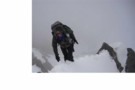
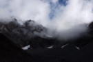
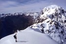
traverse of Mt Pfeifer
Photograph
•
Distance: 875m away
Traverse of ridge south-east of the summit in clag. Getting around the boulder was tricky and a bit exposed.
More ▶︎
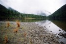
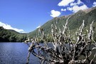
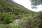
Lake Kaurapataka
Photograph
•
Distance: 3.0km away
"It can be beautiful from a distance..." (Holcroft)
dis-tance - detente (softening)? de(to do) tente(softening) (or hardening? - dis tente)... ...
More ▶︎
Lake Kaurapataka.
Photograph
•
Distance: 3.2km away
This small lake next to the Taramakau Valley is a good camping spot.
More ▶︎
Lake Kaurapataka
Track
•
1 – 2 days. Easy. Return via same track.
•
Distance: 3.2km away
Easy weekend trip to a pretty Arthur's Pass camping spot
More ▶︎
Otehake Hot Springs
Photograph
•
Distance: 3.4km away
Otehake hot springs. October 25th 2009.
More ▶︎
Otehake Hot Springs
Track
•
2 days. Easy/medium. Return via same track.
•
Distance: 3.4km away
A popular weekend route to good hot pools.
More ▶︎

Edwards River-Otehake River
Track
•
4 days. Medium. One way.
•
Distance: 3.4km away
Another north-south crossing of the park.
More ▶︎
Harper Pass - Kiwi Saddle
Track
•
5 – 7 days. Medium. One way.
•
Distance: 3.6km away
A classic crossing of the Main Divide, following the deep valleys of the Hope Fault from the Arthur's Pass road ...
More ▶︎
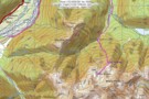
Grand Traverse of Mt Pfeifer
Article
•
Distance: 3.8km away
Traverse from Kaurapataka Saddle, over summit to Waharoa Saddle.
More ▶︎
'20 minutes' rock, Big Tops
Photograph
•
Distance: 4.1km away
'Lost track of my past/
On deception pass/
Dont know where im going/
Can't recall where ive been'
Deception Pass (Mudhoney)
More ▶︎
Taramakau in the evening from Big Tops
Photograph
•
Distance: 4.7km away
then the rain came and washed it all away...and yet keeping low doesn't make no sense so little Eiffel stands ...
More ▶︎
Otehake NZFS track up to Big Tops and down to Koropuku Hut
Track
•
1 day. Medium. One way.
•
Distance: 4.8km away
Attractive old track from Otehake swingbridge to open tops. Recent extensions cut from gully to bypass waterfalls.
More ▶︎
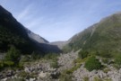
route from Otehake Track to Big Tops Hut via Koropuku Gorge
Photograph
•
Distance: 5.4km away
Untracked mission involving 1)crossing of Otehake River. Only able to be done at low flows. @) travel up Koropuku Gorge ...
More ▶︎
Mingha River-Deception River
Track
•
2 days. Medium. One way.
•
Distance: 5.4km away
Goat Pass Track. Alpine track over a pass between two river valleys.
More ▶︎
route from Otehake Track to Big Tops Hut via Koropuku Gorge
Article
•
Distance: 5.6km away
Untracked mission only able to be done when rivers at low flows (usually from December to April).
More ▶︎
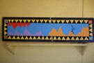
Mural gracing Koropuku hut
Photograph
•
Distance: 5.7km away
I snapped this to show my partner how cultured the inhabitants of back country huts can be. It is topical ...
More ▶︎
Koropuku Hut
Hut
•
Basic Hut/Bivvy (DOC). Capacity: 4.
•
Distance: 5.7km away
Cult Hut! A NZFS 4 bunk beauty with silken wooden floors, no fireplace, tasteful furnishings and domestic accoutrements including the ...
More ▶︎
Cockayne Nature Walk
GPX file
•
Distance: 6.1km away
Short walk in rich forest near Kellys Creek, Arthur's Pass National Park.
More ▶︎
Cockayne Nature Walk
Track
•
Easy. Loop track.
•
Distance: 6.1km away
A short loop in forest near Kelly's Creek, Otira.
More ▶︎
Kelly Shelter (Removed)
Hut
•
Removed!
•
Distance: 6.4km away
Kelly shelter is a roadside shelter on the Arthur's Pass road, at the base of Kelly's Creek and the track ...
More ▶︎
Hunts Creek Track
Track
•
2 days. Medium. Return via same track.
•
Distance: 6.4km away
Rough travel to a small, tidy hut. Better walked as part of a circuit.
More ▶︎
Lake Kaniere - Otira
GPX file
•
Distance: 6.6km away
from the north end of Lake Kaniere, along the west shore to the Styx river. East along the Styx to ...
More ▶︎
Otehake Hut
Photograph
•
Distance: 7.0km away
6 bunk NZFS style hut in the Otehake Valley, near the confluence of East & West Otehake Rivers, altitude 640m
More ▶︎
Otehake hut
Photograph
•
Distance: 7.0km away
Otehake hut is an NZFS six bunker that was built in 1963. It is the "stretched style" with a porch ...
More ▶︎
Otehake Hut
Hut
•
Standard Hut (DOC).
•
Distance: 7.0km away
Otehake Hut. NZFS six bunker with porch. Built 1962/63.
More ▶︎
Kellys Hill
Photograph
•
Distance: 7.2km away
1400m above, looking NW from Kellys Hill, APNP.
More ▶︎

Kellys Range & beyond from Kellys Hill July 2011
Photograph
•
Distance: 7.2km away
This pic looking SW from Kellys Hill was taken before this weeks heavy snowfalls. The dip in the foreground is ...
More ▶︎

Route Guide: Otira to Mt Cook Village (pt 2)
Track
•
12 – 21 days. Hard. One way.
•
Distance: 7.6km away
One possible route down the main divide from Otira on the Arthur's Pass road to Mt Cook Village.
Otira Hotel ...
More ▶︎
Route Guide: Otira to Mt Cook Village (pt 1)
Track
•
12 – 21 days. Hard. One way.
•
Distance: 7.6km away
One possible route down the main divide from Otira on the Arthur's Pass road to Mt Cook Village.
Otira Hotel to ...
More ▶︎
Kelly Range - Hunts Saddle Circuit
Track
•
2 – 3 days. Medium/hard. Loop track.
•
Distance: 7.7km away
A challenging circuit route traversing the Kelly Range and returning along Kelly's Creek. The direction described is the easiest option.
More ▶︎
Kellys Saddle
Photograph
•
Distance: 7.7km away
Kellys Saddle - a tussock saddle between the Otira and Taipo near Carroll Hut
More ▶︎

Arthur's Pass National Park
Place
•
National Park. 1145.00km2.
•
Distance: 7.7km away
This alpine park straddles the Main Divide of the Southern Alps, with dry beech forests in the east and damp ...
More ▶︎
Picton to Aspiring
GPX file
•
Distance: 8.0km away
An aborted alpine traverse. Picton to West Cape, but aborted at Aspiring due to real world emergencies back home. Posted ...
More ▶︎
Kelly Range views over Kelly Ck
Photograph
•
Distance: 8.0km away
Moving southward above Carroll hut on the Kelly Range.
Descending the range to Hunts saddle and returning by Kellys Creek resulted ...
More ▶︎
Catching the dawn on the Kelly range
Photograph
•
Distance: 8.1km away
The morning light on the Kelly range before it reaches the valley with Arthurs Pass
More ▶︎
Arthur's Pass
Photograph
•
Distance: 8.1km away
Arthiur's pass and the viaduct viewed from the Kelly Creek to Carroll's Hut track.
More ▶︎
Kelly Range
Track
•
1 – 2 days. Medium. Return by the same track.
•
Distance: 8.1km away
A brief climb up to Carroll Hut on the tops at the northern edge of Arthur's Pass National Park. Magnificent ...
More ▶︎
Carroll Hut
Photograph
•
Distance: 8.1km away
This newly renovated hut sits on a pretty tussock plateau on the Kelly Range.
More ▶︎
Carroll Memorial Hut
Photograph
•
Distance: 8.1km away
Situated on Kelly Saddle, Carroll Hut has stunning views across to Arthur's Pass.
More ▶︎
Carroll Hut
Hut
•
Standard Hut (DOC). Capacity: 10.
•
Distance: 8.1km away
A small, tidy hut just above the treeline on the Kelly Range. Recently renovated with new cladding and new windows. ...
More ▶︎
Goat Creek track to Mt Barron
Track
•
0 – 1 day. Hard. Loop track with a road section.
•
Distance: 8.1km away
Overgrown and line is destroyed by recent slips.
More ▶︎
Mt Alexander
Photograph
•
Distance: 8.4km away
Looking down on the confluence of the Otira and Taramakau rivers from Summit of Mt Alexander
More ▶︎
Mt Alexander
Photograph
•
Distance: 8.4km away
Looking back at point 1786 ,Mt Tekinga, Lake Brunner, Kangaroo Lake, Lady Lake and Swan lake
More ▶︎
Mount Alexander
Track
•
2 days. Medium. Return by the same track.
•
Distance: 8.4km away
A long climb to the summit of Mount Alexander (1958m) on the Kaimata Range. This range lies directly north of ...
More ▶︎
Mts Te Kinga & Alexander August 2011
Photograph
•
Distance: 8.4km away
This photo looks along the Te Kinga tops from the low peak near the trig to the top of Te ...
More ▶︎
Poulter Bivvy
Hut
•
Basic Hut/Bivvy (DOC). Capacity: 2.
•
Distance: 8.6km away
A new 2 bunk D.O.C. bivvy located in the headwaters of the Poulter River. It has two sleeping platforms with ...
More ▶︎
Ascent to Taruahuna Pass
Photograph
•
Distance: 8.8km away
Ascent to Taruahuna Pass from Otehake
More ▶︎
Harman Pass - Taipo River - Kelly Saddle
Track
•
3 – 5 days. Medium/hard. One way.
•
Distance: 8.9km away
A long journey through the west of Arthur's Pass National Park.
More ▶︎

Herbfields above Worsley Pass
Photograph
•
Distance: 9.1km away
Herbfields above Worsley Pass
More ▶︎
Mount Barron Route
GPX file
•
Distance: 9.2km away
Old trail leading up the the tussock tops of Mount Barron. A good benched track leads up to a rocky ...
More ▶︎
Back down the Poulter from Worsley Pass
Photograph
•
Distance: 9.3km away
Back down the Poulter from Worsley Pass
More ▶︎
Mount Barron Route
Track
•
Medium/hard. One way.
•
Distance: 9.3km away
Old access track onto the Mount Barron tussock tops.
More ▶︎
Jacko Flat hut Feb 2010
Photograph
•
Distance: 9.7km away
An old NZFS hut on a flat in the middle sections of the Crooked River. The Crooked Valley is a ...
More ▶︎
Jacko Flat hut
Hut
•
Basic Hut/Bivvy (DOC). Capacity: 6.
•
Distance: 9.7km away
An NZFS 1963 built six bunk hut on a flat in the middle sections of the Crooked River. The Crooked ...
More ▶︎
Heading back to the tent on Tarn Col
Photograph
•
Distance: 9.7km away
Chuzzman aka chuzz returning to the tent after getting yha on the cliff-sides of Tarn Col.
More ▶︎
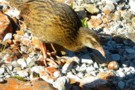
(Pihoihoi) - Pipit
Photograph
•
Distance: 9.7km away
Moaris used to mimick the pipits movements and use a tactic called Manukawhaki (decoy bird). They would pretend to retreat ...
More ▶︎
Townsend hut March 2009
Photograph
•
Distance: 9.7km away
Townsend hut which is perched high above the TL of the Taramakau River in the scrub - tussock transition zone ...
More ▶︎
Townsend hut
Hut
•
Basic Hut/Bivvy (DOC). Capacity: 4.
•
Distance: 9.7km away
Townsend hut which is perched high above the TL of the Taramakau River in the scrub - tussock transition zone ...
More ▶︎
Upper Deception Hut
Hut
•
Basic Hut/Bivvy (DOC). Capacity: 6.
•
Distance: 9.8km away
Six bunk hut adjacent the popular Mingha-Deception route. It was built by the NZFS in 1962.
[A four bunker Lower Deception ...
More ▶︎
Upper Deception hut Feb 2009
Photograph
•
Distance: 9.8km away
A sound old NZFS hut in need of a bit of TLC. The scrub badly needed cutting back last time ...
More ▶︎
Looking toward Mt Alexander from above Camp Creek hut Sept 2010
Photograph
•
Distance: 9.8km away
This picture was taken not far from where the tops track crests the ridge. Mt Alexander (1958m) is the back ...
More ▶︎
Townsend Hut
Photograph
•
Distance: 9.9km away
Early morning, heading for Lake Minchin to meet the 'Chuzzman' aka 'chuzz'.
More ▶︎
Barrack Creek Route
Photograph
•
Distance: 9.9km away
Goat Hill and Barrack Creek from Mount Barron. The route follows the spur to the true right of Barrack Creek.
More ▶︎
Below Kelly-Hunt Saddle
Photograph
•
Distance: 10.0km away
The Kelly below the Kelly-Hunt Saddle
More ▶︎