
Tramp to Kaurapataka Saddle, a low saddle between the lake and the Otahake River. Wander southeast along the gorge bypass track that leads to the hot springs until it begins to commit itself to a descent. Leave it and head uphill. As you climb, you will encounter the odd seepage to replenish your thirst. The bush is easily navigable, and the footing is soft. We came to a slip which had magnificent mountain cabbage trees, a nice sunny spot for a rest.
Eventually we reached the scrubline which had open leads. We found a soft level sheltered campsite with a little bog nearby just below a larger bog of approx 5m across on a wider flat area. This would probably be too boggy for camping nearby. There is a tarn marked on the map at 1150 m a.s.l. This is more exposed than we would like with our light 1.6kg tent! It took 3 hours from the lake to the idyllic site.
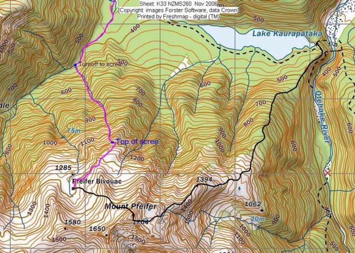
Follow the ridgeline up to point 1394 which allows good views back down to the lake. It is very pleasant travel along this ridge. Further along, you will come to a flattening where a stream leads up a gully SSW. We did this trip in the snow and clag and followed a westerly bearing to meet the Southeast ridge that travels from the summit. We walked parallel to this ridge then utilized a gully that took us to a short section of the SE ridge that attains the summit.
In snow, this was a reasonable ridge with a couple of sections of exposed snow arêtes, including an inconvenient boulder we needed to slither over with injury guaranteed on either side if we slipped. However it was enough to make the climb genuinely interesting but not too gripping…It took us about 3 hours from the scrubline campsite to the summit.
From the summit cairn, take the route directly facing the biv, not the gully slightly to your right as you face the biv. This gully route will end up in tears or bluffs which is the same thing. In summer the nice route is shingly and first uses a small ridge for a few meters to get to the flatter part of it. This then leads to scree or nice snowy slopes in the earlier part of summer.
On the final level above the biv, travel north a wee distance (150m) to gain gentler slopes that lead you to the biv.