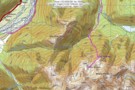
Nearby
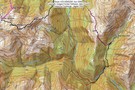
Edwards River-Otehake River
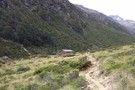
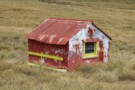
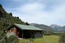
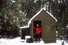
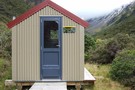
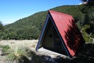
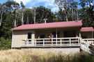
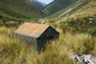
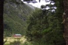
Otehake Hut
Hut
•
Standard Hut (DOC).
•
Distance: less than 100m away
Otehake Hut. NZFS six bunker with porch. Built 1962/63.
More ▶︎
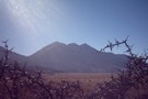
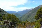
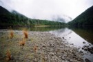
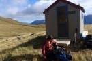
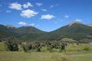
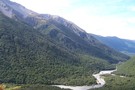
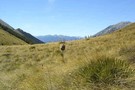
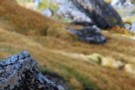
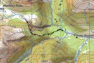
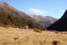
Towards Andrews and Binser
Photograph
•
Distance: less than 100m away
Taken end of Summer '06 on a brief jaunt between Hawdon and Andrews stream, nearby is a grove of gooseberries ...
More ▶︎

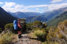
Arthur's Pass National Park
Place
•
National Park. 1145.00km2.
•
Distance: less than 100m away
This alpine park straddles the Main Divide of the Southern Alps, with dry beech forests in the east and damp ...
More ▶︎
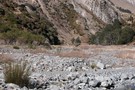
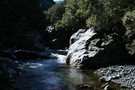
Otehake Hot Springs
Track
•
2 days. Easy/medium. Return via same track.
•
Distance: less than 100m away
A popular weekend route to good hot pools.
More ▶︎
Hawdon Shelter campsite
Campsite
•
Informal campsite (DOC). 20 spaces.
•
Distance: 725m away
Broad golden grass flats on the banks of the Hawdon River. Kea overhead and ample space to avoid the crowds. ...
More ▶︎

Edwards River-Hawdon River
Track
•
3 days. Medium. One way.
•
Distance: 730m away
See Hawdon River.
More ▶︎
East Hawdon Stream
Track
•
1 – 2 days. Easy/medium. Return via same track.
•
Distance: 746m away
A short walk to a new biv located on a branch of the Hawdon River.
More ▶︎
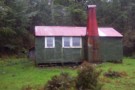
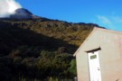
Hawdon Shelter
Hut
•
Shelter (DOC).
•
Distance: 746m away
An open shelter at the edge of extensive frost flats. Ample camping opportunities.
More ▶︎
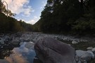
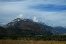
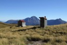
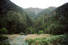
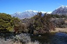
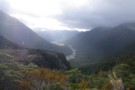
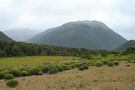
Hawdon River flats
Photograph
•
Distance: 827m away
Ample camping space around the Hawdon Shelter across the Mount White Bridge. The Pyramid (1608m) is in the background.
More ▶︎
Grand Traverse of Mt Pfeifer
Article
•
Distance: 854m away
Traverse from Kaurapataka Saddle, over summit to Waharoa Saddle.
More ▶︎
Otehake Hot Springs
Photograph
•
Distance: 954m away
Otehake hot springs. October 25th 2009.
More ▶︎
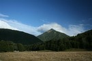
Horrible and Misery
Photograph
•
Distance: 955m away
Mounts Horrible (1234m) and Mount Misery (1765m) from the Hawdon River flats.
More ▶︎
'20 minutes' rock, Big Tops
Photograph
•
Distance: 1.1km away
'Lost track of my past/
On deception pass/
Dont know where im going/
Can't recall where ive been'
Deception Pass (Mudhoney)
More ▶︎
Lake Kaurapataka
Track
•
1 – 2 days. Easy. Return via same track.
•
Distance: 1.2km away
Easy weekend trip to a pretty Arthur's Pass camping spot
More ▶︎
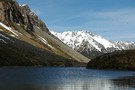
Lake Kaurapataka.
Photograph
•
Distance: 1.2km away
This small lake next to the Taramakau Valley is a good camping spot.
More ▶︎
Lake Kaurapataka
Photograph
•
Distance: 1.2km away
"It can be beautiful from a distance..." (Holcroft)
dis-tance - detente (softening)? de(to do) tente(softening) (or hardening? - dis tente)... ...
More ▶︎
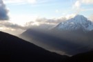
Taramakau in the evening from Big Tops
Photograph
•
Distance: 2.1km away
then the rain came and washed it all away...and yet keeping low doesn't make no sense so little Eiffel stands ...
More ▶︎
Otehake NZFS track up to Big Tops and down to Koropuku Hut
Track
•
1 day. Medium. One way.
•
Distance: 2.3km away
Attractive old track from Otehake swingbridge to open tops. Recent extensions cut from gully to bypass waterfalls.
More ▶︎
Woolshed Hill
Track
•
Medium. Hawdon Valley.
•
Distance: 2.8km away
The track begins steeply climbing through beech forest from near the Hawdon carpark. It emerges into brilliant dracophyllum draped tops ...
More ▶︎

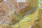
Descent from Pfeifer Biv into Pfeifer Creek via scree
Photograph
•
Distance: 2.8km away
Unmarked route exiting basin where biv lies, maintaining altitude to cross a spur after 20 minutes then travelling northeast along ...
More ▶︎
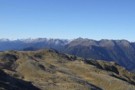
Mt Pfeifer etc from Kellys Hill July 2011
Photograph
•
Distance: 2.9km away
This photo was taken from near the broadcasting repeaters on top of Kellys Hill which is the hill immediately north ...
More ▶︎
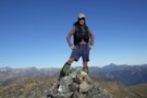
Posing on Mt Pfeifer
Photograph
•
Distance: 2.9km away
This pic looks westward from Mt Pfeifer during autumn conditions prior to the May snowfalls.
Mt Pfeifer is an easy ...
More ▶︎
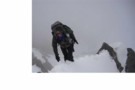
traverse of Mt Pfeifer
Photograph
•
Distance: 2.9km away
Traverse of ridge south-east of the summit in clag. Getting around the boulder was tricky and a bit exposed.
More ▶︎
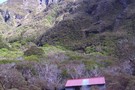
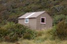
Koropuku Hut
Hut
•
Basic Hut/Bivvy (DOC). Capacity: 4.
•
Distance: 3.1km away
Cult Hut! A NZFS 4 bunk beauty with silken wooden floors, no fireplace, tasteful furnishings and domestic accoutrements including the ...
More ▶︎
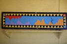
Mural gracing Koropuku hut
Photograph
•
Distance: 3.1km away
I snapped this to show my partner how cultured the inhabitants of back country huts can be. It is topical ...
More ▶︎
Paratu Stream - Waharoa Saddle
Article
•
Distance: 3.4km away
The easiest route to Mt Pfeifer via an attractive bouldered stream and a magical saddle with flybys of kaka and ...
More ▶︎
Pfeiffer Biv
Photograph
•
Distance: 3.4km away
cosy,dinky even,modern 2 bunker with longdrop nearby.
More ▶︎
birds-eye view
Photograph
•
Distance: 3.5km away
Looking from Waharoa Saddle down Pfeifer Stream & to Lake Kaurapataka
More ▶︎
Pfeifer biv & toilet April 2012
Photograph
•
Distance: 3.5km away
A new biv from early 2008 replacing an old biv that was about 20m to the south. (The sign on ...
More ▶︎
Pfeifer biv
Hut
•
Basic Hut/Bivvy (DOC). Capacity: 2.
•
Distance: 3.5km away
A new biv from early 2008 replacing an old biv that was about 20m to the south. (The sign on ...
More ▶︎
"Old" Pfeifer biv (Removed) Dec 2007
Photograph
•
Distance: 3.5km away
The old biv a few months before it was replaced.
More ▶︎
Penny Pass
Track
•
3 – 4 days. Medium. Loop track.
•
Distance: 3.7km away
3 day trip from upper Poulter River over Penny Pass between Minchin and Thompson Streams.
More ▶︎
Andrews Shelter campsite
Campsite
•
Informal campsite (DOC). 20 spaces.
•
Distance: 3.8km away
Free camping on flats next to Andrews Stream. A sturdy shelter is located here. From here, the Andrews Valley Track ...
More ▶︎
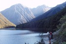
Lake Minchin
Photograph
•
Distance: 3.8km away
Not far from the new Poulter Hut, though the old Trust Poulter Hut has more 'character' and is quite liveable. ...
More ▶︎
Andrews Stream-Lake Minchin-Townsend Creek
Track
•
4 days. Medium. One way.
•
Distance: 3.8km away
A north-south crossing of the park.
More ▶︎
Andrews Shelter
Photograph
•
Distance: 3.8km away
An enclosed shelter at the beginning of the Andrews Track leading to Casey Saddle.
More ▶︎
Andrews Shelter
Hut
•
Shelter (DOC).
•
Distance: 3.8km away
Shelter and campsite on Andrews Stream near the Mount White Bridge. Water is available from the nearby stream. Here, or ...
More ▶︎
Casey Saddle - Poulter River - Binser Saddle
Track
•
2 – 3 days. Easy/medium. Loop track with a short road section.
•
Distance: 3.8km away
A brief circuit crossing one open saddle and one bush saddle in the southeastern corner of Arthur's Pass National Park. ...
More ▶︎
route from Otehake Track to Big Tops Hut via Koropuku Gorge
Article
•
Distance: 3.9km away
Untracked mission only able to be done when rivers at low flows (usually from December to April).
More ▶︎
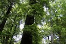
Red beech forest
Photograph
•
Distance: 4.3km away
Red beech occupies some of the flat terrace above Andrews Stream, Andrews Track, Arthur's Pass National Park.
More ▶︎
route from Otehake Track to Big Tops Hut via Koropuku Gorge
Photograph
•
Distance: 4.4km away
Untracked mission involving 1)crossing of Otehake River. Only able to be done at low flows. @) travel up Koropuku Gorge ...
More ▶︎
Sudden valley track
Article
•
Distance: 4.9km away
Comments to add to other articles about Sudden Valley
More ▶︎
Sudden Valley
Article
•
Distance: 4.9km away
Sudden Valley off Hawdon Valley - Arthurs Pass
Great short trip in times of low rainfall
More ▶︎
"New" Sudden Valley biv Feb 2010
Photograph
•
Distance: 5.1km away
Replacement for old biv. This biv is only a short distance from the Hawdon Shelter. You can get in and ...
More ▶︎
Sudden Valley Biv
Hut
•
Basic Hut/Bivvy (DOC). Capacity: 2.
•
Distance: 5.1km away
The small dark biv was replaced Summer 2008. Camping is possible around the biv.
More ▶︎
Sudden Valley
Track
•
2 days. Medium. Return via same track.
•
Distance: 5.1km away
A secluded hanging valley in the southeast corner of Arthur's Pass National Park
More ▶︎
Harper Pass - Kiwi Saddle
Track
•
5 – 7 days. Medium. One way.
•
Distance: 5.2km away
A classic crossing of the Main Divide, following the deep valleys of the Hope Fault from the Arthur's Pass road ...
More ▶︎
Hawdon Valley - Discovery Flat
Photograph
•
Distance: 5.2km away
View looking to the south across the Hawdon Valley at Discovery Flat. Taken from the track up from the Hawdon ...
More ▶︎
Hawdon River
Track
•
2 days. Easy. Return via same track.
•
Distance: 5.2km away
Easy travel up a wide river valley.
More ▶︎
Cass-Lagoon Saddle
Track
•
2 days. Medium. One way.
•
Distance: 5.5km away
This classic route from Cass to Cora Lynn Road circles the Black Range to form an open loop, and a ...
More ▶︎
Cass Saddle
Track
•
1 day. Easy/medium. One way.
•
Distance: 5.6km away
From the car park at the east end of the Cass road bridge, follow the vehicle track next to the ...
More ▶︎
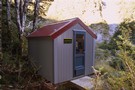
Poulter Bivvy
Hut
•
Basic Hut/Bivvy (DOC). Capacity: 2.
•
Distance: 5.8km away
A new 2 bunk D.O.C. bivvy located in the headwaters of the Poulter River. It has two sleeping platforms with ...
More ▶︎
Townsend hut March 2009
Photograph
•
Distance: 6.3km away
Townsend hut which is perched high above the TL of the Taramakau River in the scrub - tussock transition zone ...
More ▶︎
Townsend hut
Hut
•
Basic Hut/Bivvy (DOC). Capacity: 4.
•
Distance: 6.3km away
Townsend hut which is perched high above the TL of the Taramakau River in the scrub - tussock transition zone ...
More ▶︎
Townsend Hut
Photograph
•
Distance: 6.5km away
Early morning, heading for Lake Minchin to meet the 'Chuzzman' aka 'chuzz'.
More ▶︎
Craigieburn Forest Park
Place
•
Conservation Park. 441.65km2.
•
Distance: 6.9km away
A small park south of Arthur's Pass National Park including a series of ski fields. Highest point: 2141m (Mt Avoca).
More ▶︎

Discovery Stream/Sudden Valley traverse
Article
•
Distance: 7.0km away
2 day circuit from Hawden River, crossing mountain ridgetop after approach from Discovery Stream which features boulder-hopping and cascades.
More ▶︎
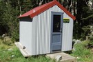
Otehake Hut
Photograph
•
Distance: 7.1km away
6 bunk NZFS style hut in the Otehake Valley, near the confluence of East & West Otehake Rivers, altitude 640m
More ▶︎
Otehake hut
Photograph
•
Distance: 7.1km away
Otehake hut is an NZFS six bunker that was built in 1963. It is the "stretched style" with a porch ...
More ▶︎
Way out, Cass Lagoon Saddle
Photograph
•
Distance: 7.4km away
Hamilton Hut is so nice. Great view.Will be back!!
More ▶︎

Herbfields above Worsley Pass
Photograph
•
Distance: 7.5km away
Herbfields above Worsley Pass
More ▶︎
Back down the Poulter from Worsley Pass
Photograph
•
Distance: 7.5km away
Back down the Poulter from Worsley Pass
More ▶︎
The Descent Route of the NW Tributary of Discovery Stream
Photograph
•
Distance: 7.7km away
this route avoids waterfalls
More ▶︎
Descent Route from NW Tributary of Discovery Stream
Photograph
•
Distance: 7.7km away
This avoids waterfalls
More ▶︎
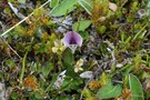
Carmichaelia monroi
Photograph
•
Distance: 7.8km away
A tiny dwarf broom growing north of Hallelujah Flat, Andrews Track, Arthur's Pass National Park.
More ▶︎
Binser Saddle
Campsite
•
Backcountry Campsite (Not applicable).
•
Distance: 7.8km away
Sheltered flat site with plenty of beach wood for a campfire. It's just before the high point of the saddle ...
More ▶︎
Circuit from Binser Saddle to Hallelujah Flat
Article
•
Distance: 7.9km away
Overnight camp on Binser Saddle followed by 9 hour circuit along tops north of saddle and down to Hallelujah Flats, ...
More ▶︎

Hawdon Hut
Hut
•
Serviced Hut (DOC). Capacity: 20.
•
Distance: 8.0km away
A new hut opened in December 2007 after the previous hut was destroyed by fire June 2005.
An easy two to ...
More ▶︎
Binser Saddle from flats near Andrews Shelter
Photograph
•
Distance: 8.0km away
Binser Saddle (1085m) is a low, forested saddle.
More ▶︎
Peak a chamois - Townsend Tops
Photograph
•
Distance: 8.2km away
Occasionally when walking between Townsend hut and Minchin pass you may play peak a boo with the wildlife.
More ▶︎
Approaching Casey Saddle
Photograph
•
Distance: 8.2km away
Casey Saddle (777m) is a flat, barely perceptible saddle. Castle Hill (1545m) is behind.
More ▶︎
Mingha River-Deception River
Track
•
2 days. Medium. One way.
•
Distance: 8.5km away
Goat Pass Track. Alpine track over a pass between two river valleys.
More ▶︎
Minchin Bivvy Feb 2016
Photograph
•
Distance: 8.5km away
The photo is of Minchin Biv & is taken looking down Minchin Stream. It was built by the NZFS (New ...
More ▶︎
The Recutting of the NZFS track to Worsley Pass
Article
•
Distance: 8.6km away
How we searched for, found, recut and marked this ancient track that had been lost for 25 years.
More ▶︎
Worsley Biv
Hut
•
Basic Hut/Bivvy (DOC). Capacity: 3.
•
Distance: 9.0km away
Recently renovated (thanks CUTC with Kerry Clapham) with new ridgeline and skylight 'A' frame Maori bunk biv, with 3 foam ...
More ▶︎
NZFS track to Worsley Pass and deer trail route in Poulter Gorge
Photograph
•
Distance: 9.1km away
They were bitchin' in the hut book about this track in 1988. No work done on it for a long ...
More ▶︎
East Hawdon Biv
Photograph
•
Distance: 9.2km away
The shiny new two-bunk hut in the frosty East Hawdon Valley.
More ▶︎
East Hawdon Bivouac
Hut
•
Basic Hut/Bivvy (DOC). Capacity: 2.
•
Distance: 9.3km away
A smart new hut on East Hawdon Stream. It was built 2007, replacing the original biv.
More ▶︎
Edwards Hut
Hut
•
Serviced Hut (DOC). Capacity: 16.
•
Distance: 9.4km away
Well built hut, sleeps 16 people.
More ▶︎
Edwards Hut Toilet
Photograph
•
Distance: 9.4km away
View down the valley from the Edwards hut.
More ▶︎
Sidle Mt Valiant
Photograph
•
Distance: 9.4km away
A good direct route from the East Hawdon to the head of the Poulter at Trudge stream, Arthurs Pass National ...
More ▶︎
Veiw from campsite on Amber Col
Photograph
•
Distance: 9.4km away
This just shows the route up to Amber Col from the Otehaki river on the bottom right, Falling Mtn on ...
More ▶︎

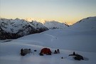
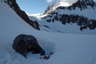
First Light Amber Col
Photograph
•
Distance: 9.4km away
5:30am God it's early, beautiful light, freezing cold, about an hour before total white-out.
More ▶︎
Amber Col
Photograph
•
Distance: 9.4km away
September 2008
Stayed the previous night at the new Hawdon Hut, then made my way over Walker Pass and up the ...
More ▶︎
Walker Pass Tarn
Photograph
•
Distance: 9.9km away
October 08,
Tarn on Walker Pass looking back towards the Hawdon Valley
More ▶︎