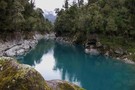
Nearby
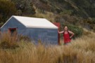
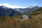
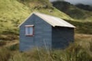
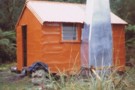
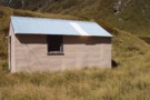
Healey Creek hut May 2008
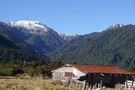
Healey Creek hut
Hut
•
Basic Hut/Bivvy (DOC). Capacity: 4.
•
Distance: less than 100m away
A tidy four bunker toward the head of Healey Creek a Mikonui River tributary. The hut is on a tussock ...
More ▶︎
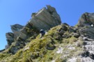
Healey Spur Feb 2014
Photograph
•
Distance: 1.8km away
This photo shows the last steep bit of Healey Spur before reaching the relatively easy going of Galena Ridge at ...
More ▶︎
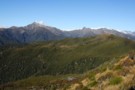
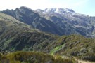
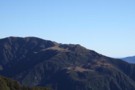
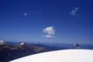
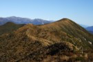
View SE from Bald Hill Range June 2013
Photograph
•
Distance: 2.3km away
This picture was taken from the crest of the Bald Hill Range NE of Bald Hill.
The tussock and low ...
More ▶︎
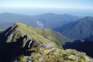
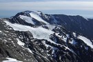
Remarkable Peak
Photograph
•
Distance: 2.3km away
This photo shows Remarkable Peak 1790m in spring conditions. It is the tooth like peak centre picture. The pic was ...
More ▶︎
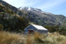
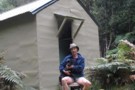
Mikonui Spur biv Nov 2007
Photograph
•
Distance: 3.1km away
The subject J H & photographer, not me in this case, Horse G are sometimes tramping companions. They, like myself, ...
More ▶︎
Looking up Mikonui Spur Dec 2010
Photograph
•
Distance: 3.1km away
This pic is taken from the track on the spur below the biv and looks up past the biv in ...
More ▶︎
Mikonui Spur biv Dec 2010
Photograph
•
Distance: 3.1km away
A pic of the biv with Mt Bowen behind to the SE.
More ▶︎
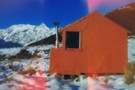
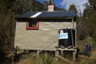
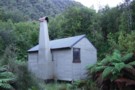
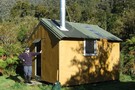
Mikonui Spur Bivvy
Hut
•
Basic Hut/Bivvy (DOC). Capacity: 2.
•
Distance: 3.1km away
A traditional forestry bivvy that has braved many a Tasman Sea storm, on an exposed ridge top above the Mikonui ...
More ▶︎
Route to Healey Ck hut from Mikonui Flat
Photograph
•
Distance: 3.3km away
From the track start on the Flat it's a bit over 2hrs of up hill then 20 minutes down to ...
More ▶︎
Dickie Spur hut & Tuke River headwaters Jan 2012
Photograph
•
Distance: 3.5km away
Here is another photo of Dickie Spur hut to go with the one from 1975 that I posted on here. ...
More ▶︎
Dickie Spur from Healey Spur May 2008
Photograph
•
Distance: 3.5km away
This photo looks SW across the Tuke River to Dickie Spur and the northern end of Dickie Ridge. If you ...
More ▶︎
Dickie Spur hut July 1975
Photograph
•
Distance: 3.5km away
This hut is in the scrub tussock transition zone on a spur running east toward the Tuke River off the ...
More ▶︎
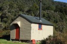
Dickie Spur hut
Hut
•
Basic Hut/Bivvy (DOC). Capacity: 4.
•
Distance: 3.5km away
This hut is in the scrub tussock transition zone on a spur running east toward the Tuke River off the ...
More ▶︎
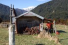
Mikonui Flat hut May 2008
Photograph
•
Distance: 4.2km away
This is the first of the DOC huts when heading up the Mikonui River. It is on the TL about ...
More ▶︎
Mikonui Flat hut
Hut
•
Standard Hut (DOC). Capacity: 6.
•
Distance: 4.2km away
This is the first of the DOC huts when heading up the Mikonui River. It is on the TL about ...
More ▶︎
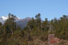
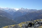
Mt Bowen from Fraser Peak March 2013
Photograph
•
Distance: 4.3km away
This photo of Mt Bowen 1965m was taken from near the summit of Fraser Peak 1166m. Both peaks lie between ...
More ▶︎
Looking SW from Mt Diedrichs May 2013
Photograph
•
Distance: 4.3km away
This photo taken from beside the trig beacon on the summit of Mt Diedrichs 1084m looks SW over the Hokitika ...
More ▶︎
Top Tuke hut Dec 1975
Photograph
•
Distance: 4.6km away
This four bunk hut is located on the TR in the head basin of the Tuke River a tributary of ...
More ▶︎
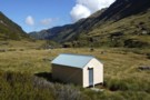
Top Tuke hut
Hut
•
Basic Hut/Bivvy (DOC). Capacity: 4.
•
Distance: 4.6km away
This four bunk hut is located on the TR in the head basin of the Tuke River a tributary of ...
More ▶︎
Top Tuke hut March 2012
Photograph
•
Distance: 4.6km away
Here is a photo of this hut from a different angle than the 1975 one I posted and "major's" one ...
More ▶︎
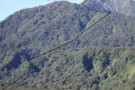
Dickie Spur
Photograph
•
Distance: 5.4km away
A perfect day on the Dickie Spur above the Mikonui River, looking towards Okarito
More ▶︎
Old shed & beyond. Mikonui Flat July 2010
Photograph
•
Distance: 5.5km away
This old shed is next to the old homestead on Mikonui Flat.
Beyond the shed is the Mikonui River and then ...
More ▶︎
Historic Homestead Mikonui Flat Sept 2007
Photograph
•
Distance: 5.5km away
This small old farm dwelling is on the TR of the Mikonui flats & is referred to as "The Old ...
More ▶︎
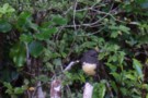
SI Bush Robin
Photograph
•
Distance: 5.5km away
This friendly bird kept me company at Explorer hut the couple of nights I was there recently. It would come ...
More ▶︎
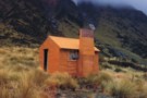
Explorer Hut
Hut
•
Basic Hut/Bivvy (DOC). Capacity: 4.
•
Distance: 5.5km away
A small hut located near Douglas Saddle.
Easiest access is from the Mikonui valley. None of the routes are recommended in ...
More ▶︎
Explorer hut Sept 2007
Photograph
•
Distance: 5.6km away
Explorer hut Douglas Saddle. Mikonui River/Doctors Creek (a tributary of the Hokitika River)
More ▶︎
Mt Beaumont (2131m) April 2012
Photograph
•
Distance: 5.6km away
This pic looks at Mt Beaumont from the south and was taken from the crest of the Lange Range while ...
More ▶︎
Black Hut Totara Valley & beyond
Photograph
•
Distance: 7.0km away
This July shot taken from beside the Totara Valley road shows Black Hut. The higher country in the back ground ...
More ▶︎
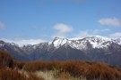
Looking SW along the Bald Hill Range June 2013
Photograph
•
Distance: 7.0km away
This photo shows the easy tussock tops of the Bald Hill Range. Bald Hill is the tussocky high point down ...
More ▶︎
Polluck Creek hut Sept 2007
Photograph
•
Distance: 7.3km away
This hut is situated on a low terrace on the TR of the Kakapotahi River 700 metres above the junction ...
More ▶︎
Polluck Creek hut Jan 2012
Photograph
•
Distance: 7.4km away
A recent pic from a different angle to go with the existing photo of the hut on this site.
Polluck Creek ...
More ▶︎
Polluck Creek hut
Hut
•
Basic Hut/Bivvy (DOC). Capacity: 6.
•
Distance: 7.4km away
This hut is situated on a low terrace on the TR of the Kakapotahi River 700 metres above the junction ...
More ▶︎
Whitcombe Pass & Butler Saddle
Article
•
Distance: 8.8km away
route guide attached by for Hokitika Gorge to Erewhon via Whitcombe Pass & Butler Saddle. The guide was written by ...
More ▶︎
Whitcombe Pass
Track
•
5 – 7 days. Medium/hard. One way.
•
Distance: 9.2km away
This route follows the famous journey by John Henry Whitcombe and the Swiss guide Jakob Lauper across the Main Divide ...
More ▶︎
Rapid Creek hut May 1975
Photograph
•
Distance: 9.2km away
An older pic of the hut after it had got its first replacement chimney. These days the hut has a ...
More ▶︎
Rapid Creek hut June 2008
Photograph
•
Distance: 9.2km away
This is a four bunker on the TL of the Hokitika River not far below the junction with the Whitcombe ...
More ▶︎
Rapid Creek hut
Hut
•
Basic Hut/Bivvy (DOC). Capacity: 4.
•
Distance: 9.2km away
This is a four bunker on the TL of the Hokitika River not far below the junction with the Whitcombe ...
More ▶︎
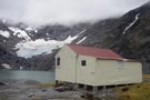
Ivory Lake Hut
Hut
•
Basic Hut/Bivvy (DOC). Capacity: 6.
•
Distance: 9.4km away
An old Meteorological Service hut located in a picturesque location at the head of the Waitaha Valley. No toilet. A ...
More ▶︎
Top Waitaha hut March 2012
Photograph
•
Distance: 9.5km away
This hut is an NZFS six bunker that was built in 1968. It has no open fire or stove. There ...
More ▶︎
Top Waitaha hut
Hut
•
Basic Hut/Bivvy (DOC). Capacity: 6.
•
Distance: 9.5km away
This hut is an NZFS six bunker that was built in 1968. It has no open fire or stove. There ...
More ▶︎
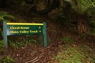
Which Way?
Photograph
•
Distance: 9.7km away
I would suggest staying away from the flood route unless you have to as its very steep and long!
More ▶︎
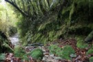
Typical track on the tramp
Photograph
•
Distance: 9.7km away
The typical looking track on the tramp, if there has been rain/or is raining expect to get a bit of ...
More ▶︎
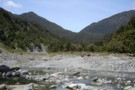
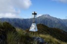
View of the hills that lead to the huts
Photograph
•
Distance: 9.7km away
the crossing is slightly to the left of the middle
More ▶︎
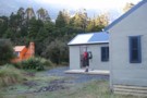
Historic Cedar Flats Hut
Photograph
•
Distance: 9.7km away
A well maintained old hut. 2 bunks
More ▶︎
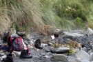
Cedar Flats Hot Springs
Photograph
•
Distance: 9.7km away
Perfect hot springs in a secluded hokitika valley. Holds upto 6 people.
More ▶︎
Price Basin hut
Hut
•
Basic Hut/Bivvy (DOC). Capacity: 4.
•
Distance: 9.8km away
This hut, which is usually known as Price(s) Basin, is located on the TL of the TR branch of the ...
More ▶︎
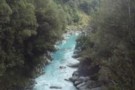
Whitcombe River gorge
Photograph
•
Distance: 9.9km away
Whitcombe River gorge, upstream from Frew Hut
More ▶︎
Historic Price Flat Hut
Hut
•
Basic Hut/Bivvy (DOC). Capacity: 4.
•
Distance: 10.0km away
Slab hut once used for deer culling and possibly dating to 1908. The hut is located next to the newer ...
More ▶︎