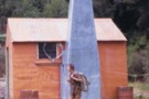
Nearby
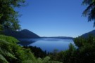
View from Hans Bay Lake Kaniere Aug 2015
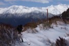
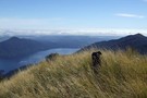
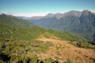
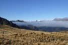
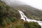
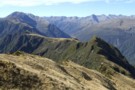
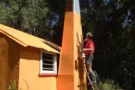
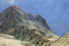
Mt Tuhua Sept 2010
Photograph
•
Distance: less than 100m away
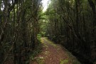
Yesterday morning I took advantage of the first nice day for a while to head up Mt Tuhua which is ...
More ▶︎
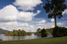
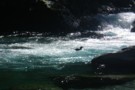
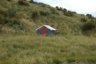
Hans Bay, Lake Kaniere
Photograph
•
Distance: less than 100m away
Hans Island is just a short swim from the shoreline.
More ▶︎
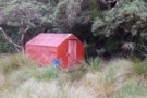
Hans Bay Campsite
Campsite
•
Basic Campsite (DOC). 40 spaces.
•
Distance: 114m away
Large campsite next to Lake Kaniere. Very popular with families over the summer.
Dogs are not permitted.
More ▶︎
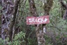
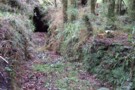
Another old track sign July 2012
Photograph
•
Distance: 1.4km away
Ian G's. picture of an old National Park sign still marking a track in the Urewera got me thinking. I ...
More ▶︎
Kahikatea Walk, Lake Kaniere
Track
•
Easy. Loop track.
•
Distance: 2.2km away
Short loop through mossy forest.
More ▶︎
Lake Kaniere - Otira
GPX file
•
Distance: 2.2km away
from the north end of Lake Kaniere, along the west shore to the Styx river. East along the Styx to ...
More ▶︎
Tracks to the "New" Mt Brown hut
GPX file
•
Distance: 4.6km away
Here is a gpx file. It shows the new huts location & the routes to the hut from the Geologists ...
More ▶︎
Mt Brown Hut
Track
•
1 – 2 days. Medium. Loop track with a road section.
•
Distance: 4.6km away
A circuit in the foothills behind Hokitika. Excellent views and a nice little hut.
More ▶︎
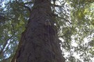
Insulator grown into Rimu tree near Dough Town August 2012
Photograph
•
Distance: 5.0km away
I snapped this picture of an old telegraph insulator at least 3m up a rimu tree. It is beside the ...
More ▶︎
Dough Town Track July 2012
Photograph
•
Distance: 5.0km away
Bits of an old miners track that linked Humphreys Gully to Dough Town & then carried on to Milltown still ...
More ▶︎
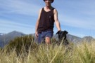
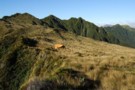
glennj & Elle dog on summit of Mt Brown April 2011
Photograph
•
Distance: 5.2km away
Summit of Mt Brown. It is the Browning Range in the background.
Yesterday was such good weather I decided to head ...
More ▶︎
Lake Kaniere etc from top of Mt Brown April 2011
Photograph
•
Distance: 5.2km away
This pic shows Elle dog on Mt Brown with views out to the coast behind. The Lake is Kaniere and ...
More ▶︎
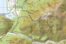
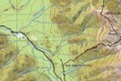
Mt Brown summit & circuit routes March 2011
Photograph
•
Distance: 5.3km away
This map shows the actual track/routes overlayed in solid black lines on a Topo 50 map. The "old" Mt Brown ...
More ▶︎
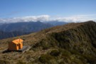
The Mt Brown ridge construction site May 2010
Photograph
•
Distance: 5.3km away
Looking SW from Mt Brown ridge over top of the early stages of construction of the "new" hut.
The "old" Lower ...
More ▶︎
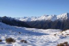
View out to coast from Mt Brown hut
Photograph
•
Distance: 5.3km away
This view is taken just a few steps from Mt Brown hut and looks back toward the track start and ...
More ▶︎
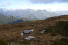
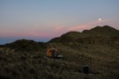
Lunch time at Mt Brown hut Dec 2010
Photograph
•
Distance: 5.3km away
The four younger members of the group of five of us that walked up to check out the new hut.
The ...
More ▶︎
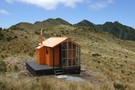
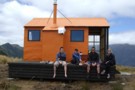
Mt Brown hut & beyond Dec 2010
Photograph
•
Distance: 5.3km away
This hut replaces, but on a different site, the old Mt Brown hut which was removed by DOC about five ...
More ▶︎
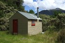
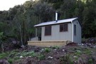
Mt Brown Hut
Hut
•
Basic Hut/Bivvy (Mt Brown Community Hut Project). Capacity: 4.
•
Distance: 5.3km away
This hut replaces the old Mt Brown hut which was removed by DOC in 2006. The hut is in a ...
More ▶︎
View up Styx valley from Mt Brown hut June 2012
Photograph
•
Distance: 5.3km away
This photo looks up the Styx valley and was taken from outside Mt Brown hut. If you look closely you ...
More ▶︎
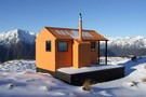
Mt Brown hut June 2012
Photograph
•
Distance: 5.3km away
Here is a winter time pic of the hut.
More ▶︎
Leaving Mt.Browns Tops
Photograph
•
Distance: 5.3km away
A good stretch of the legs. Everyone else we saw on this walk and there were a few, was staying ...
More ▶︎
Mount Brown Hut
Photograph
•
Distance: 5.3km away
Perched on a cliff overlooking Lake Kaniere.
More ▶︎
Mt Brown hut & Newton Range April 2013
Photograph
•
Distance: 5.3km away
This photo shows how the popular Mt Brown hut sits in relation to the Newton Range.
As well as tramps to ...
More ▶︎
Southern descent of Mt.Browns Tops
Photograph
•
Distance: 5.3km away
Moving through a boggy section of the Mt.Browns Tops route just before dropping over the edge into the creek.
That's ...
More ▶︎
Kaniere Water Race Track
Photograph
•
Distance: 5.3km away
Kaniere Water Race Track from Lake Kaniere towarss rhe Kaniere township
More ▶︎
Looking up the Styx from near the New Mt Brown hut
Photograph
•
Distance: 5.4km away
This pic taken yesterday was snapped from the tussock section below the hut whilst heading for the start of the ...
More ▶︎
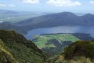
Lake Kaniere
Photograph
•
Distance: 6.2km away
Lake Kanierec from lookout below Mt Upright, Lake Kaniere track
More ▶︎
Old Water Race below Lower Arahura hut
Photograph
•
Distance: 6.5km away
Here is a photo of a remnant section of the water race that runs roughly parallel with the current track ...
More ▶︎
Three Passes
Track
•
4 – 5 days. Medium/hard. One way.
•
Distance: 7.2km away
A classic trip from Arthur's Pass across Browning, Whitehorn and Harman Passes, emerging near Lake Kaniere on the West Coast.
More ▶︎
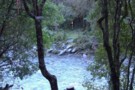
Blue Duck at the Tyndall / Styx confluence
Photograph
•
Distance: 8.0km away
Blue Duck at the Tyndall / Styx confluence
More ▶︎
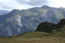
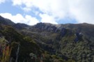
View of McArthur Crags from the Newton Range Jan 2008
Photograph
•
Distance: 8.5km away
This picture was taken from just north of the Newton Range biv. I took it to show the band of ...
More ▶︎
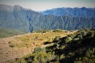
Mt Kerr
Photograph
•
Distance: 8.9km away
Exploring the exposed tops above the Arahura RIver just before a front rolls in. Reached by an old NZFS track ...
More ▶︎
Newton Range biv Jan 2008
Photograph
•
Distance: 9.1km away
This biv is perched near the crest of the Newton Range. This range seperates the Arahura River to the north ...
More ▶︎
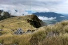
Looking eastward along the Newton Range April 2012
Photograph
•
Distance: 9.2km away
This picture was taken from a spot on the range a bit over an hour west of the bivvy. The ...
More ▶︎
Newton Range biv
Hut
•
Basic Hut/Bivvy (DOC). Capacity: 2.
•
Distance: 9.2km away
This NZFS biv built in 1962 is perched near the crest of the Newton Range. This range seperates the Arahura ...
More ▶︎
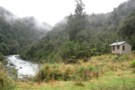
Mid Styx hut Feb 2009
Photograph
•
Distance: 9.3km away
This photo of Mid Styx hut was taken during a "Permolat" working bee when a group of volunteers worked on ...
More ▶︎
Track to Mid Styx Hut
Track
•
Easy. Loop track.
•
Distance: 9.3km away
Recently recut 40 minute track to this front country hut renovated by volunteers from the Permolat on-line community.
More ▶︎
Mid Styx Hut
Article
•
Distance: 9.3km away
Our trip in to check out this hut restored by the Permolat Community
More ▶︎
Mid Styx Hut
Hut
•
Basic Hut/Bivvy (NA). Capacity: 4.
•
Distance: 9.3km away
4 person ex-NZFS hut with open fireplace on north facing terrace high above the Styx River. Renovated extensively and maintained ...
More ▶︎
Short cut to Mid Styx hut
Photograph
•
Distance: 9.3km away
This photo shows the turnoff to Mid Styx hut as described below.
Easiest access to Mid Styx hut is the Styx ...
More ▶︎
Mid Styx Hut painting March 2014
Photograph
•
Distance: 9.3km away
Volunteers have prepared & painted the hut exterior. This is just the second paint job this 1960 built hut has ...
More ▶︎
Route down off McArthur Crags to Lower Olderog biv Jan 2010
Photograph
•
Distance: 9.6km away
This pic shows the SE leading spur off the top of Mt McArthur that leads down to Lower Olderog biv. ...
More ▶︎
Lower Olderog biv (aka Jade biv) Feb 2009
Photograph
•
Distance: 9.6km away
This biv is located on a bench well above the creek bed in the headwaters of Jade Creek. It is ...
More ▶︎
Lower Olderog biv (aka Jade biv)
Hut
•
Basic Hut/Bivvy (DOC). Capacity: 2.
•
Distance: 9.6km away
This NZFS biv dating from 1957 is located on a bench well above the creek bed in the headwaters of ...
More ▶︎
"Old" Lower Arahura hut (removed)
Photograph
•
Distance: 9.7km away
This photo shows the "old" Lower Arahura hut as it was in January 1976 when it had recently received a ...
More ▶︎
"New" Lower Arahura hut June 2010
Photograph
•
Distance: 9.7km away
A replacement DOC 6 bunk hut for the old NZFS 4 bunk hut that used to sit 30m to the ...
More ▶︎
Lower Arahura hut
Hut
•
Standard Hut (DOC). Capacity: 6.
•
Distance: 9.7km away
A new DOC 6 bunk hut that replaces the old 4 bunk NZFS hut. The new hut is 30m east ...
More ▶︎
Lower Arahura Hut
Photograph
•
Distance: 9.8km away
A nice new 6 bunk hut in the Arahura valley.
More ▶︎
View of Turiwhate Range from the SW
Photograph
•
Distance: 9.8km away
This photo looking up to the crest of the range was taken from a gap in the scrub zone of ...
More ▶︎
Turiwhate Range from the South West
Photograph
•
Distance: 9.8km away
On Sunday I walked up Mt Turiwhate from the SW. Historically the range has usually been accessed from the NW ...
More ▶︎