Nearby
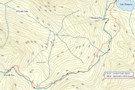
Maling Pass to Lake Guyon junction
Section: Maling Pass - Moki Track
Track
•
1 day. Easy/medium. One way.
•
Distance: less than 100m away
The northernmost section of the St James Cycle Trail, between Lake Tennyson and the Lake Guyon junction on the Waiau ...
More ▶︎
Maling Pass, Lake Guyon, Fowler Pass circuit
Track
•
2 days. Easy/medium. Loop track with a road section.
•
Distance: less than 100m away
This circuit is a double-crossing of the St James Range, dropping into the deep Waiau Uwha Valley. The first day's ...
More ▶︎
Maling Pass to Lake Guyon
GPX file
•
Distance: less than 100m away
From Lake Tennyson, cross Maling Pass into the deep Waiau Valley, then turn off to Lake Guyon.
More ▶︎
McArthur Track
GPX file
•
Distance: less than 100m away
Pool Hut to Lake Guyon junction, St James Conservation Area.
More ▶︎
Lake Guyon junction to Lake Guyon Hut
GPX file
•
Distance: less than 100m away
Short diversion up from the Waiau Uwha valley to the hut next to a small lake.
More ▶︎
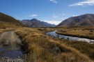
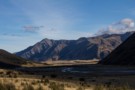
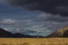
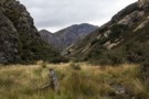
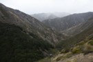
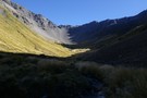
Waiau Valley
Photograph
•
Distance: 236m away
The view up toward Waiau Pass from beneath Maling Pass. The Waiau Pass is up to the left.
More ▶︎
Ada Flat
Photograph
•
Distance: 319m away
The view across Ada Flat toward the St James Walkway.
More ▶︎
Maling Pass Track
Photograph
•
Distance: 434m away
The start of the 4WD road over Maling Pass. This road is open to vehicles and bikes.
Lake Tennyson is ...
More ▶︎
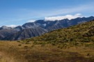
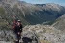
Crossing Maling Pass
Photograph
•
Distance: 659m away
The climb to the pass is easy, but it is deceptively high: 1308m. Over the pass is Mount Una (2300m) ...
More ▶︎
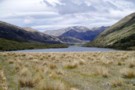
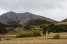
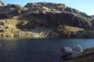
Lake Guyon
Photograph
•
Distance: 1.0km away
The hut is just over the little forested promontory at left. Mount Clara (1945m) is beyond.
More ▶︎
Lake Tennyson Campsite
Campsite
•
Informal campsite (DOC). 10 spaces.
•
Distance: 1.7km away
Expansive campsite on the tussock shoreline of Lake Tennyson, on Molesworth Station. The campsite is close to the start of ...
More ▶︎
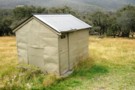
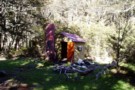
Wild toilet
Photograph
•
Distance: 1.7km away
Lake Tennyson Campsite. The view behind is the Clarence Valley. This is a standard Department of Conservation "Norski" brand fibreglass ...
More ▶︎
Lake Tennyson
Photograph
•
Distance: 1.7km away
The lake in a Norwester wind, from the campsite and shelter.
More ▶︎
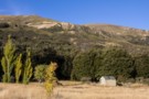
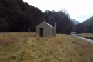
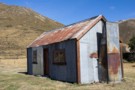
Lake Guyon homestead site and hut
Photograph
•
Distance: 2.0km away
The small hut is just metres from the lake. Poplars and old fruit trees mark the site of the pastoral ...
More ▶︎
Fowler Pass Track
GPX file
•
Distance: 2.0km away
From Lake Guyon and Stanley Vale, a zig zag up to Fowler Pass then the long straight run out to ...
More ▶︎
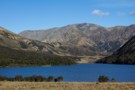
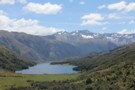
Lake Guyon
Photograph
•
Distance: 2.0km away
Lake Guyon on the Waiau River, north of the St James Walkway. There is 4WD access fron the Clarence River ...
More ▶︎
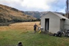
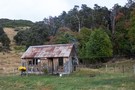
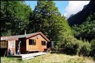
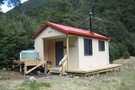
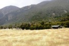
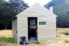
Lake Guyon Hut
Photograph
•
Distance: 2.0km away
A top location by a pristine lake with park like stands of beech forest nearby. Easy access through the former ...
More ▶︎
Lake Guyon Hut
Hut
•
Standard Hut (DOC). Capacity: 4.
•
Distance: 2.0km away
Standard 4 bunk hut on the shore of Lake Guyon, a popular fishing lake. This little hut is just 30 ...
More ▶︎
Circuit from Stanley Vale to Glenrae Saddle/Lake Hill/Lake Guyon
Article
•
Distance: 2.0km away
A day's tramping to an seldom visited picturesque area near the St James Cycleway.
More ▶︎
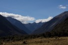
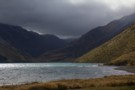
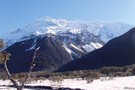
Waiau Pass
Photograph
•
Distance: 2.2km away
View south down to the Waiau River valley from Waiau Pass
More ▶︎
Waiau - Clarence Pass Lake Tennyson Circuit
Track
•
4 – 5 days. Medium/hard. Loop track.
•
Distance: 2.2km away
A challenging 4-5 day circuit in the St. James Conservation Area / Nelson Lakes National Park featuring two alpine pass ...
More ▶︎
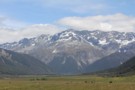
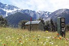
Faerie Queene (2236m)
Photograph
•
Distance: 3.0km away
Looking across the Ada Flats from the McArthur Track. Wild St James horses in the foreground. The St James Walkway ...
More ▶︎
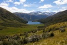
Lake Guyon
Photograph
•
Distance: 4.0km away
Mount Una (2300m) in behind. The hut is located on the distant grass flat.
More ▶︎
Lake Guyon
Photograph
•
Distance: 4.0km away
Mount Una (2300m) in behind. The hut is located on the distant grass flat.
More ▶︎
Malings Pass, L. Guyon, Stanleyvale, Sandy Stream Circuit
Article
•
Distance: 4.3km away
2 day circuit with the first day in spectacular scenery on the St James cycleway with a 500m ascent of ...
More ▶︎
Waiau Hut
Hut
•
Standard Hut (DOC). Capacity: 6.
•
Distance: 4.4km away
New hut on the Waiau Pass Track and Te Araroa Trail. This hut was opened 27 January 2018, and constructed ...
More ▶︎
Boyle Flats Hut
Photograph
•
Distance: 4.5km away
Perched high on a river terrace, accessed from a swingbridge 'on the Boyle'.
More ▶︎
Ada Cullers Hut
Photograph
•
Distance: 4.5km away
Tidy old shack provides shelter and shade from the elements. No mattresses or water supply.
More ▶︎

St James Walkway
Track
•
5 days. Easy/medium. One way.
•
Distance: 4.5km away
A long and easy walk on St James Station near Lewis Pass. Beech forest, mountain scenery, farmland, wild horses, mud.
More ▶︎
St James Walkway June 2009
Photograph
•
Distance: 4.5km away
Gloriana and the Faerie Queene, on a brilliant winter's day.
More ▶︎
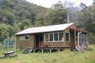
Stanley Vale Hut
Hut
•
Basic Hut/Bivvy (DOC). Capacity: 7.
•
Distance: 5.0km away
An historic farming homestead on the Stanley Vale Run, built by Joseph Young about 1866. The hut is built of ...
More ▶︎
Stanley Vale Hut
Photograph
•
Distance: 5.0km away
Historic homestead at Stanley Vale in the St James Conservation Area.
More ▶︎
Stanley Vale
Photograph
•
Distance: 5.2km away
Retired pastoral land around Stanley Vale Hut.
More ▶︎
Christopher Hut
Photograph
•
Distance: 5.3km away
Christopher Hut on the Ada River. Part of the Saint James Walkway
More ▶︎
Stanley River Valley
Photograph
•
Distance: 5.4km away
One of the routes out of Stanley Vale.
More ▶︎
Ada Cullers Hut
Hut
•
Basic Hut/Bivvy (DOC). Capacity: 4.
•
Distance: 5.7km away
Christopher (Ada) Cullers Hut.
More ▶︎
Ada Cullers Hut
Photograph
•
Distance: 5.8km away
Ada Cullers Hut is an historic Hut about 15 minutes from Christopher Hut on the St James Walkway. 4 bunks
More ▶︎
Christopher Hut
Hut
•
Serviced Hut (DOC). Capacity: 14.
•
Distance: 6.0km away
Christopher hut.
More ▶︎
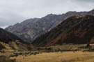
Old fencing, Stanley Vale
Photograph
•
Distance: 6.5km away
The route to Fowler Pass, following the Stanley River between Mount Laura on left and Rabbit Hill on right. Long ...
More ▶︎
Thompson Pass
GPX file
•
Distance: 7.3km away
Caroline Creek Hut, Upper Waiau Valley to East Matakitaki Hut via Thompson Pass & Unamed Pass
More ▶︎
Thompson Pass
GPX file
•
Distance: 7.3km away
Caroline Creek Hut, Upper Waiau Valley to East Matakitaki Hut via Thompson Pass & Unamed Pass
More ▶︎
Caroline Creek Bivvy
Hut
•
Basic Hut/Bivvy (DOC). Capacity: 2.
•
Distance: 7.3km away
A nice little bivvy with 2 canvas bunks and an open fire
More ▶︎
Near Fowler Pass
Photograph
•
Distance: 7.9km away
Climbing past Anniversary Point on the way to the zig zag.
More ▶︎
Wairau-Paske saddle
Photograph
•
Distance: 8.4km away
The saddle at the head of the Wairau, crossing into the Paske. Tiring climbing on loose scree, but a non-technical ...
More ▶︎

Blue Lake Hut - Bobs Hut
GPX file
•
Distance: 8.5km away
Blue Lake campsite to Bob’s Hut, via Lake Thompson and D’Urville Pass
An actual, recorded, gpx – the high route section ...
More ▶︎

Route Guide: St Arnaud to Lewis Pass
Article
•
Distance: 8.6km away
A 5-7 day north-south route from St Arnaud to the Lewis Pass, via Travers Pass, Waiau Pass, Thompson Pass and ...
More ▶︎
East Matakitaki Hut
Photograph
•
Distance: 8.6km away
East Matakitaki Hut in the east branch of the Matakitaki Valley.
More ▶︎
East Matakitaki Hut
Hut
•
Standard Hut (DOC). Capacity: 6.
•
Distance: 8.6km away
East Matakitaki Hut (6 bunk, matresses, fireplace, creek water) lies on river flats in the upper Matakitaki valley (east branch). ...
More ▶︎

Lake Thompson
Photograph
•
Distance: 8.6km away
A view of the beautiful Lake Thompson, a short distance from Thompson Pass
More ▶︎
East Matakitaki Hut
Photograph
•
Distance: 8.6km away
beside the river and at the southern end of the flats, we found this 6-berth hut in great condition
Feb 2013
More ▶︎
St Arnaud - Lewis Pass
Article
•
Distance: 8.6km away
A 9-day 100km tramp via the Thompson, D'Urville and 3 Tarns Passes
Feb 2013
More ▶︎

Profile : St Arnaud - Lewis Pass
Photograph
•
Distance: 8.6km away
A useful profile of the 100km tramp - with a couple of bad weather alternatives :
1. low route past Speargrass ...
More ▶︎
Max Smart memorial plaque, Matakitaki valley
Photograph
•
Distance: 8.8km away
Memorial plaque to Max Smart on the true left of the Matakitaki upriver of the East Matakitaki Hut. The quote ...
More ▶︎

Waiau Uwha Valley
Photograph
•
Distance: 9.0km away
Looking north upvalley from Saddle Spur. The bridge is at bottom right. St James Walkway curls around the flats at ...
More ▶︎
St Arnaud to Lewis Pass
Track
•
5 – 9 days. Medium/hard. One way.
•
Distance: 9.0km away
A 5-9 day north-south route from St Arnaud to the Lewis Pass, via Travers Pass, Waiau Pass, Thompson Pass and ...
More ▶︎
St James Conservation Area
Place
•
Place. 781.96km2.
•
Distance: 9.3km away
A large new recreational area featuring tussock grasslands, and including the headwaters of the Waiau and Clarence Rivers.
More ▶︎
Fowlers Hut
Hut
•
Shelter (DOC).
•
Distance: 9.4km away
Historic hut on Tophouse Road, St James Conservation Area. The hut is being managed as a roadside shelter, and is ...
More ▶︎
Fowlers Hut
Photograph
•
Distance: 9.4km away
Historic rabbiters' hut next to Tophouse Road in the St James Conservation Area. The Fowlers Pass Track starts here. A ...
More ▶︎
Edwards River, Lake Guyon, Fowler Pass circuit
Track
•
3 days. Easy/medium. Loop track with a road section.
•
Distance: 9.4km away
This circuit explores the southern portion of the St James Cycle Trail, explores the historic farm country around Lake Guyon ...
More ▶︎
Section: Lake Guyon - Fowler Pass
Track
•
1 day. Easy/medium. One way.
•
Distance: 9.4km away
A route connecting the Waiau Uwha and Waiau Toa (Clarence) valleys, from Lake Guyon junction on the St James Cycle ...
More ▶︎
Molesworth Recreation Reserve
Place
•
Reserve. 1807.87km2.
•
Distance: 9.4km away
An iconic high country station located behind the Kaikoura Ranges.
More ▶︎