Waiau - Clarence Pass Lake Tennyson Circuit
- 4 – 5 days loop track
- Medium/hard
A challenging 4-5 day circuit in the St. James Conservation Area / Nelson Lakes National Park featuring two alpine pass crossings and some unmarked track route finding. Starts and ends at Lake Tennyson and can be done in either direction.
|
Walking time
|
4 – 5 days
34 hr – 42 hr
|
|---|---|
|
Distance
|
78.0km |
|
Type
|
Loop track
|
|
Grade
|
Medium/hard
Sections of this track are graded hard especially so in winter conditions Grades explained
|
|
Bookings
|
No bookings — open access
No — open access
|
|
Starts
|
Lake Tennyson |
|---|---|
|
Maps
|
NZTopo50-BT24
NZTopo50-BS24 |
|
Altitude
|
660m
–
1,880m
Altitude change 1,220m
|
This track description is for a trip in the anti-clockwise direction which was chosen to suit the available daylight hours for Day 1 and the weather forecast. Access is via Tophouse road to Lake Tennyson Car Park, 48km of gravel road from Hanmer Springs. The car park is situated beside the south-east shores of the lake and has public toilets.
Day 1 Lake Tennyson - Caroline Creek Bivvy via Maling Pass (17km 4-5 hours)
From the car park cross the lake outlet and head west across the tussock flats to intersect with the dual-use horse trekking/mountain-biking 4WD road (part of the St. James cycleway) and up to Maling Pass (1308m). After descending from the pass to the Waiau Valley floor (2 - 2.5 hours) the Waiau River track north veers off to the right. Follow the 4WD track upstream on the true right crossing where necessary until Caroline Creek Bivvy (2 - 2.5) hours. There are a number of potential camp sites in the beech forest here with good access to the Waiau river. There are no toilet facilities. Ex-station stock horses roam the valley.
Day 2 Caroline Creek Bivvy - Blue Lake Hut via Waiau Pass (14km 9-11 hours)
Follow the river upstream on the true right using the recently recut track (March 2010). After about 2 hours cross the river to a fly camp in a stand of beech. This would make a good alternative campsite to Caroline Biv if you wish to get in a better position for the climb ahead. From here the river heads up the valley in a southwest direction towards Lake Thompson. A new track provides a higher traverse to avoid river travel and then reaches an expansive mixed scrub and tussock covered area with good views of the Spenser Range and Mount Mahunga. The route to the pass has been repoled and involves some rock scrambling higher up. At about 1700m there is a rock chute that would require care in winter especially in the reverse direction. Once above the chute it is a short climb to the ridge top approach to the pass (1870m). Water is available on the climb until about 1500m elevation which is also where there you can see Lake Thompson to the south.
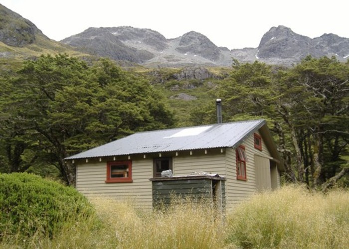
Descend from the Pass using the poled route towards Lake Constance. The track around the west side of the lake has a steep 150m climb over a bluff at the northern end. While it is tempting to try and avoid this last fitness test by travelling around the lake shore that route and the east shore are effectively blocked by the rock bluffs even at low lake levels. There is a superb view of the popular Blue Lake from the track leading across the old terminal moraine wall down to Blue Lake Hut.
Day 3 Blue Lake Hut - East Sabine River via West Sabine Hut (20km 9-10 hours)
The route from Blue Lake Hut initially follows the well-maintained track as far as the bridged West Sabine river crossing to West Sabine Hut. Signs clearly indicate the many avalanche paths along this track. If you want to go to the hut you can save some time by crossing the river 100 metres or so before the bridge, as soon as you spot the hut on the true right.
From the hut follow the Travers Saddle route for about 1 - 1.5 hours until a sharp left turn in the track marks the descent to the footbridge over the impressive Sabine River canyon. Continue straight ahead at this point. The route now follows the east branch of the Sabine upriver and is largely unmarked with extensive windfall, new growth, rockfall and avalanche debris slowing progress. Initially there are some permolat markers for 1-2 km, presumably remnants of the old Travers Saddle route. There are several suitable campsites on the way upstream and a number of old deer tracks to provide the occasional respite from the bush bashing.
Day 4 East Sabine River - Clarence River Valley via Clarence Pass (16km 9-10 hours)
Continue up the East Sabine River using whatever route finding makes for the easiest travel until the valley opens up looking towards Belvedere Peak. At about 1400m stay on the true left as there are a number of deep ravines which will be difficult to cross further up. The route to the Pass is not marked but on approaching the cirque start a traverse up the steep tussock and snowgrass slopes. The final approach can be made from a number of gaps in the rock bluffs above. The Clarence Pass (1880m) is quite expansive but with little protection from the elements. There are excellent views of the many peaks surrounding the unnamed lake at the head of the valley and to the south the Clarence River flats.
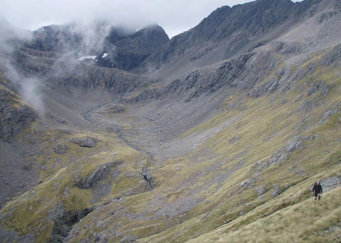
The route to the valley floor is also unmarked and first involves a scree slide then a traverse across a large expanse of shattered rock followed by a very steep descent on snowgrass. A number of potential paths downhill will be bluffed out at the lower reaches. Once on the valley floor there is yet more rock to negotiate until a cattle track is picked up on the true left. Continue downstream for about an hour to a campsite behind a large boulder adjacent to a stream. Further downstream a small stand of beech 300m off the track could also offer some protection.
Day 5 Clarence River Valley - Lake Tennyson (12km 3 - 4 hours)
Follow the cattle / 4WD track down the Clarence River on the true left for about 2 hours to reach the northern edge of Lake Tennyson. The route from here on the eastern side of the lake is a mixture of lake edge sand with some time above the high-water mark in the small stands of beech and the extensive mixed scrub. After an hour the track finishes back at the car park where you started.