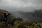
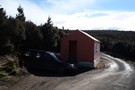
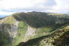
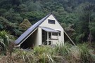
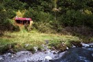
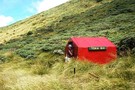
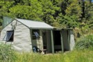
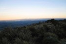
Nearby
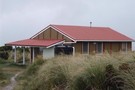
Long view to Howletts
Longview to Howletts
Photograph
•
Distance: 106m away
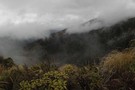
Moments before the clag decended the rest of the weekend was wet and misty
More ▶︎
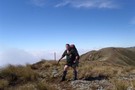
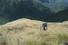
Walking the length of the Ruahines
Track
•
10 – 25 days. Medium/hard. One way.
•
Distance: 194m away
A 10+ day trip down to backbone of the Ruahine Range from Wharite (Palmerston Sth) to the Napier Taihape (Gentle ...
More ▶︎
Longview Howletts Daphne Circuit
GPX file
•
Distance: 696m away
A circuit in the Ruahines taking in three well equiped huts
More ▶︎
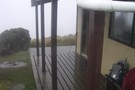
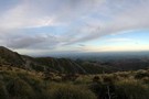
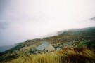
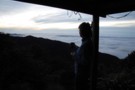
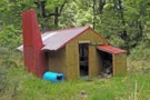
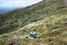
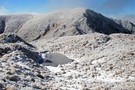
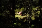
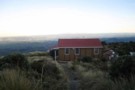
View from longview hut-or lack of
Photograph
•
Distance: 2.0km away
View from the hut with about50-150m visibility, really bad weather for tramping but still enjoyable
More ▶︎
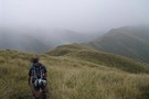
Longview Track
Photograph
•
Distance: 2.0km away
Very exposed track that can become dangerous, at the very least, unpleasant due to high winds.
More ▶︎
Longview Track
Photograph
•
Distance: 2.0km away
Very exposed track that can become dangerous, at the very least, unpleasant due to high winds.
More ▶︎
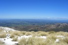
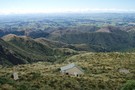
Longview Pano
Photograph
•
Distance: 2.0km away
Panorama of Central Hawke's Bay from Longview Hut.
More ▶︎
Longview track
Photograph
•
Distance: 2.0km away
Looking out towards napier/coast around about 1280 metres asl along the daphne-longview track just before the last climb to the ...
More ▶︎
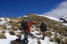
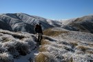
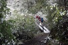
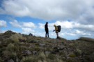
Trampers on route to Longview Hut
Photograph
•
Distance: 2.0km away
Photo is taken just out of the bush from the daphne hut track,Was a very windy day though. Snow up ...
More ▶︎
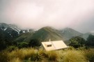
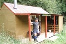
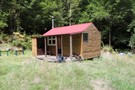
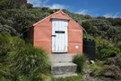
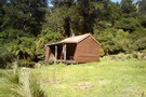
Longview Hut
Hut
•
Serviced Hut (DOC). Capacity: 12.
•
Distance: 2.0km away
Longview hut (12 bed platforms, firewood, tank water,non-flush toilet) provided a view of nothing but mist on the occasion I ...
More ▶︎
Walking the length of the Ruahines
Article
•
Distance: 2.0km away
This article documents my recollections of the Ruahine setion (Wharite to Kuripapango) of a walk from Wharite near Palmerston North ...
More ▶︎
Longview Makaretu Awatere Circuit
Track
•
2 days. Easy/medium. Loop track.
•
Distance: 2.0km away
2 Day circuit in the Ruahine Forrest park from Moorcock Saddle 3 huts some tops bush and river travel.
More ▶︎
Longview Howletts Daphne Circuit
Track
•
2 – 3 days. Medium. Loop track with a road section.
•
Distance: 2.0km away
A circuit in the Ruahines taking in three well equiped huts
More ▶︎
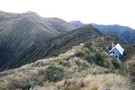
The route from Longview Hut to Howletts Hut
Photograph
•
Distance: 2.8km away
This photo is taken from Daphne Ridge on the way to Howletts Hut. Longview is behind the higest point on ...
More ▶︎
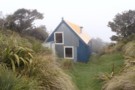
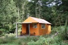
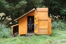
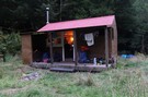
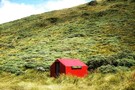
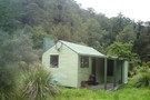
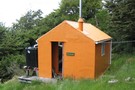
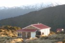
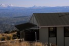
Howletts Hut
Photograph
•
Distance: 3.5km away
Tucked into a fold in the ridge a welcome site on a bad day
More ▶︎
Waiting for the sunrise at Howletts
Photograph
•
Distance: 3.5km away
Howletts is ideally positioned to view the sun rising over Hawkes Bay
More ▶︎
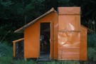
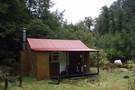
Howletts Hut
Photograph
•
Distance: 3.5km away
Howletts is in an idylic spot, in a hollow on the ridge top
More ▶︎
Howletts Hut
Hut
•
Standard Hut (Heretaunga Tramping Club). Capacity: 8.
•
Distance: 3.5km away
Howletts Hut is located below the 1682m Taumatamekura Peak and the last rest heading north before the infamous Sawtooth Ridge.
The ...
More ▶︎
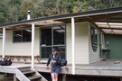
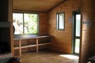
Daphne Hut
Hut
•
Standard Hut (DOC). Capacity: 8.
•
Distance: 3.6km away
8 to 10 person hut.It's in a stunning spot where the northern and western branches of the Tukituki converge. Note, ...
More ▶︎
Daphne Hut
Photograph
•
Distance: 3.6km away
Showing Daphne Hut's location on the river bank
More ▶︎
Top Gorge hut
Photograph
•
Distance: 3.7km away
Top Gorge Hut in the head waters of the Pohangina River in the Ruahines. Can be reached from Longview Hut, ...
More ▶︎
Top Gorge Hut
Hut
•
Basic Hut/Bivvy (DOC). Capacity: 2.
•
Distance: 3.7km away
Top Gorge Hut (2 bunks, 3 mattresses, open fire with ample firewood available, river water) is a small, basic hut ...
More ▶︎
Rangiwahia Triangle Iron gate Alice Nash Memorial
GPX file
•
Distance: 4.4km away
Typical Ruahine weekend tramp 4 huts, open tops,river travel and some great bush.
More ▶︎
Awatere Hut
Hut
•
Basic Hut/Bivvy (DOC). Capacity: 3.
•
Distance: 4.6km away
Nice 3 bunk hutin the ruahines built in 1957, nice ridge travel over from Kashmir rd.
Mainly used by hunters.
Also 10 ...
More ▶︎
Triangle Hut
Hut
•
Basic Hut/Bivvy (DOC). Capacity: 6.
•
Distance: 4.7km away
6 bunk hut in the Oroua river catchment. On a raised terrace above the river. Water from the river, pot ...
More ▶︎
Triangle Hut
Photograph
•
Distance: 4.7km away
6 bunk hut situated on a bench above the river very pleasant
More ▶︎
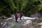
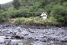
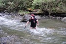
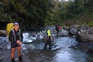
A Freezing River Trip in Winter
Photograph
•
Distance: 4.7km away
A winters's river trip in the Ruahines - attempting to keep the circulation going!
More ▶︎
Triangle Hut
Photograph
•
Distance: 4.7km away
Triangle Hut in The Western Ruahine Range. can be reached via Rangiwahia Hut and over the tops. River route downstream ...
More ▶︎
Rangiwahia Triangle Iron gate Alice Nash Memorial
Track
•
2 – 3 days. Medium. One way.
•
Distance: 4.8km away
Typical Ruahine weekend tramp 4 huts, open tops,river travel and some great bush.
More ▶︎
Iron Gate Hut
Photograph
•
Distance: 4.8km away
Iron Gate Hut on the Oroua River western Ruahines
More ▶︎
Iron Gate Hut
Photograph
•
Distance: 4.8km away
A damp morning at Iron Gate Hut in the Western Ruahine Ranges.
More ▶︎
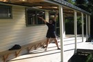
Great inventions
Photograph
•
Distance: 4.9km away
I wouldnt be without my walking pole anymore
More ▶︎
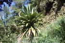
Cordyline Banksii ?
Photograph
•
Distance: 5.0km away
In Damp bush there where a couple of impressive specimens is the discription right
More ▶︎
Iron Gate Hut
Hut
•
Standard Hut (DOC). Capacity: 8.
•
Distance: 5.5km away
Iron Gate Hut (sleeps 8, stove, stream water) sits on the beech-forested banks of the Oroua River. It's a comfortable ...
More ▶︎
Tarn Bivvy
Hut
•
Basic Hut/Bivvy (DOC). Capacity: 2.
•
Distance: 6.3km away
Tarn biv, near the tarn on Black Ridge.
More ▶︎
Toka Biv
Photograph
•
Distance: 6.4km away
Toka Biv in the Ruahine Range Between Toka and Tunopo. Used to be called Ngamoko Biv. It sits on a ...
More ▶︎
Toka Biv
Photograph
•
Distance: 6.4km away
Toka Biv in the Ruahine Range Between Toka and Tunopo. Used to be called Ngamoko Biv. It sits on a ...
More ▶︎
Descent to Triangle Hut
Photograph
•
Distance: 6.5km away
About 800 metrs the descent into pleasant bush is welcome on a hot day
More ▶︎
Toka Biv
Hut
•
Basic Hut/Bivvy (DOC). Capacity: 2.
•
Distance: 6.5km away
Toka Biv (2 bunk, tarn water) is a small dog-box bivvy on a small plateau on the Pohongina Valley side ...
More ▶︎
Longview hut on ridge
Photograph
•
Distance: 6.6km away
The small white dot on the rige is longview hut from the ridge on the way to awatere hut
More ▶︎
Awatere Hut
Photograph
•
Distance: 6.6km away
Nice walk over ridge from kashmir road end, road is abit dodgy now that they have run a grader over ...
More ▶︎

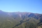
Sawtooth Ridge
Photograph
•
Distance: 6.7km away
Looking south along the Sawtooth towards Tiraha (Ruahine Ranges)
More ▶︎
Maungahuia
Photograph
•
Distance: 6.9km away
Frozen tarn and Maungahuia (1583m), above Rangiwahia Hut. Part of the Rangi - Deadmans Ridge Circuit. July 2012
More ▶︎
Above Rangiwahia Hut, looking towards Maungahuia
Photograph
•
Distance: 7.2km away
Looking towards Maungahuia (1583m) Part of the Rangiwahia - Deadmans Ridge circuit. July 2012
More ▶︎
Happy Daze Hut
Hut
•
Basic Hut/Bivvy (DOC). Capacity: 4.
•
Distance: 7.4km away
Small, with ample camping. Seems to be some dispute over naming, with Happi Daze being (somewhat forcefully) pushed by some.
More ▶︎
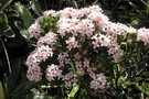
Pimelea near Toka
Photograph
•
Distance: 7.5km away
Pimelea in flower near Toka Trig, Ngamoko Range in the western Ruahines (Poss P. Buxifolia)
More ▶︎
Makaretu
Hut
•
Standard Hut (DOC). Capacity: 8.
•
Distance: 7.6km away
8 Bunk hut Southern branch Makaretuu river. Visit as part of a circuit from moorcock saddle including Longview and Awatere ...
More ▶︎
Makaretu Hut
Photograph
•
Distance: 7.6km away
8 bunk hut on the southern branch of the Makaretu river
More ▶︎
Leon Kinvig Hut
Photograph
•
Distance: 8.4km away
Leon Kinvig Hut is in the middle reaches of the Pohangina River in the Ruahines and can be reached from ...
More ▶︎
Leon Kinvig Hut
Hut
•
Standard Hut (DOC). Capacity: 8.
•
Distance: 8.4km away
Leon Kinvig Hut sleeps 8 on 2 platforms. There's a good open fire, plenty of wood around, and water from ...
More ▶︎
Pohongina River at Leon Kinvig hut
Photograph
•
Distance: 8.4km away
Grassy faces and scattered beech predominate on the Pohongina valleysides above Leon Kinvig
More ▶︎
Leon Kinvig Hut
Photograph
•
Distance: 8.4km away
A tidy 8-bunk hut in the mid-reaches of the Pohongina Valley. Tracks climb both ranges to the east and west, ...
More ▶︎
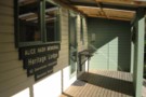
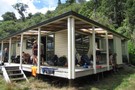
Alice Nash Memorial Lodge
Photograph
•
Distance: 8.5km away
NZ Deer stalkers hut Ruahine forest park 30 mins from the road end popular with families its more like a ...
More ▶︎
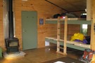
Fireplace and Bunks
Photograph
•
Distance: 8.5km away
in the Hut, got absolutely boiling in there with that fire!
More ▶︎
Alice Nash Memorial Heritage Lodge
Photograph
•
Distance: 8.5km away
Half an hour from the road end, this is a well appointed sort of place, thanks to NZDA
More ▶︎
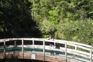
Bridge to Heritage Lodge
Photograph
•
Distance: 8.6km away
Wooden arched bridge on the track to Heritage, Ruahines
More ▶︎
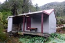
Pourangaki Hut
Photograph
•
Distance: 8.9km away
Last day of Autumn, with frost on the ground all day.
Cosy little hut in the Ruahines, although the toilet can ...
More ▶︎
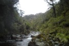
Pourangaki River
Photograph
•
Distance: 9.0km away
Heading down the Pourangaki River from the swingbridge to Kelly Knight Hut. This was one of the first of 44 ...
More ▶︎
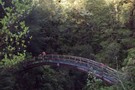
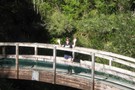
Bridge to Heritage Lodge
Photograph
•
Distance: 9.0km away
Wooden arched bridge on the track to Heritage, Ruahines
More ▶︎
Umutoi bridge snow
Photograph
•
Distance: 9.1km away
Snow on the track to Alice Nash Heritage Lodge, at the bridge over Umutoi stream. May 2009.
More ▶︎
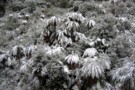
Umutoi ferns snow
Photograph
•
Distance: 9.1km away
Snow on tree ferns at Umutoi stream on the track to Alice Nash Heritage Lodge. May 2009.
More ▶︎
Pourangaki Hut
Photograph
•
Distance: 9.1km away
Pourangaki Hut from the Porangaki - Hikurangi track
More ▶︎
Pourangaki Hut
Photograph
•
Distance: 9.1km away
A warm sheltered hut in the upper Pourangaki valley in the Ruahine Ranges
More ▶︎
Pourangaki Hut
Hut
•
Standard Hut (DOC). Capacity: 8.
•
Distance: 9.1km away
Pouragaki Hut (8-bunk, stove, tank water) is a warm, sheltered hut in a north-facing grassy basin above the Pourangaki River, ...
More ▶︎
Broken Ridge, Ruahine
Photograph
•
Distance: 9.2km away
On Broken Ridge, above Hinerua hut. taken Dec 2009
More ▶︎
Ruahine travel
Photograph
•
Distance: 9.2km away
The ridge from Rangiwahia Hut to the top of the whanahuia range. An easy stroll well marked by the passage ...
More ▶︎
Rangiwahia Hut
Hut
•
Serviced Hut (DOC). Capacity: 13.
•
Distance: 9.4km away
A tidy popular hut. Great views.
Good camping on the tops about 40 minutes further along track.
More ▶︎
Rangi Hut
Photograph
•
Distance: 9.4km away
Rangi Hut from up on the little hill just next to it!!
More ▶︎
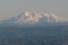
Ruapehu from Rangi Hut
Photograph
•
Distance: 9.4km away
Mount Ruapehu from the rangi hut sept 06, 2008, approx 6:30am in the morning
More ▶︎
Rangiwahia Hut
Photograph
•
Distance: 9.4km away
14 bunks gase heater could sleep double that number on the floor
More ▶︎
Rangiwahia Hut
Photograph
•
Distance: 9.4km away
Located on the western side of the Ruahine Rangers it is accessibly by tramping for approximately 3 hours up a ...
More ▶︎
Rangiwahia Hut and Central Plateau
Photograph
•
Distance: 9.5km away
Ragiwahia Hut and Mts Ruapehu and Ngauruhoe on a fine mid winters day.
More ▶︎
Ruahine Frost
Photograph
•
Distance: 9.5km away
Heading down the track to Pourangaki River, looking across to the Pourangaki tops. Heavy frost on the ground all day ...
More ▶︎