Nearby
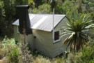
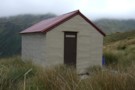
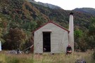
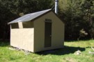
Elizabeth hut Aug 2010
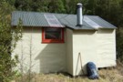
Elizabeth hut
Hut
•
Standard Hut (DOC). Capacity: 6.
•
Distance: less than 100m away
A tidy hut in the headwaters of the Haupiri River a couple of km's below Trent Saddle. Built by the ...
More ▶︎
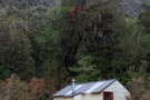
Elizabeth Hut
Photograph
•
Distance: less than 100m away
Located in the upper reaches of the Haupiri River.
(6 Bunks.)
More ▶︎
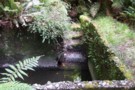
Remains of bath at Haupiri hot springs Feb 2010
Photograph
•
Distance: less than 100m away
These springs became a tourist attraction in the early 1900's. They were one of NZ's remotest developed hot springs. The ...
More ▶︎
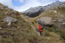
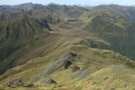
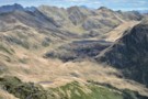
Trent Saddle Nov 2010
Photograph
•
Distance: 2.5km away
This pic shows Trent Saddle looking from the Haupiri side through to the Trent side. JH is in the pic. ...
More ▶︎
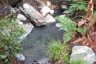
Haupiri Hot Spring
Photograph
•
Distance: 3.2km away
A hot spring barely big enough for two people, but could be dug out. Good temperature. Located where Cone Creek ...
More ▶︎
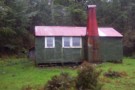
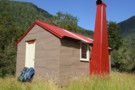
Cone Creek hut Feb 2010
Photograph
•
Distance: 4.2km away
In the West Branch of the Haupiri River.
Access from up the Haupiri River or by dropping off the Lake Morgan ...
More ▶︎
Cone Creek hut
Hut
•
Basic Hut/Bivvy (DOC). Capacity: 6.
•
Distance: 4.2km away
In the West Branch of the Haupiri River.
More ▶︎
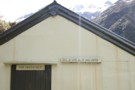
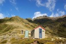
Signs on Top Trent hut
Photograph
•
Distance: 4.2km away
"Give up hope all ye who enter"
Thought I'd record the quirky sign on the hut.
I've a strong idea on ...
More ▶︎
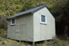
Top Trent aka Lagoon hut Nov 2010
Photograph
•
Distance: 4.2km away
An old Forest Service four bunker in the head of the Trent River. The hut is getting minimal maintenance from ...
More ▶︎
Top Trent aka Lagoon hut
Hut
•
Basic Hut/Bivvy (DOC). Capacity: 4.
•
Distance: 4.2km away
An old Forest Service four bunker in the head of the Trent River. The hut is getting minimal maintenance from ...
More ▶︎
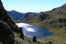
Looking toward Lake Morgan March 2010
Photograph
•
Distance: 6.7km away
This shot was taken from high on the slopes of Mt O'Shanessy & looks south to Lake Morgan. The hut ...
More ▶︎
Lake Morgan hut
Hut
•
Basic Hut/Bivvy (DOC). Capacity: 6.
•
Distance: 6.7km away
On the tops between the Haupiri & Crooked Rivers. The surrounding tops are something special! Lake Morgan is a half ...
More ▶︎
Locke Stream (No. 4) Hut
Hut
•
Serviced Hut (DOC). Capacity: 18.
•
Distance: 6.9km away
Once known as No. 4 Hut, this hut was build in 1939 as a tourist hut for the Harper Pass ...
More ▶︎
Picton to Aspiring
GPX file
•
Distance: 6.9km away
An aborted alpine traverse. Picton to West Cape, but aborted at Aspiring due to real world emergencies back home. Posted ...
More ▶︎
Harper Pass - Kiwi Saddle
Track
•
5 – 7 days. Medium. One way.
•
Distance: 7.0km away
A classic crossing of the Main Divide, following the deep valleys of the Hope Fault from the Arthur's Pass road ...
More ▶︎
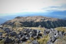
Lake Morgan from Mt.O'Shanessy March 2019
Photograph
•
Distance: 7.3km away
Our first view of the basin containing Lake Morgan. We have just gone over the bouldery 1400m peak a short ...
More ▶︎
Westland tops with the Brian O'Lyn route March 2019
Photograph
•
Distance: 7.4km away
There are several approaches to the Lake Morgan.
This is a route from the north and that is partly marked on ...
More ▶︎
Top Crooked hut Feb 2010
Photograph
•
Distance: 7.8km away
JH relaxing with a cuppa outside the hut. Note rata flowering in the background.
More ▶︎
Top Crooked hut
Hut
•
Basic Hut/Bivvy (DOC). Capacity: 4.
•
Distance: 7.8km away
An ex NZFS four bunker in the headwaters of the Crooked River.
More ▶︎
Mid Trent hut Nov 2010
Photograph
•
Distance: 9.1km away
A tidy four bunker on the TR of the Trent River. As the name suggests it is in the middle ...
More ▶︎
Mid Trent hut
Hut
•
Standard Hut (DOC). Capacity: 4.
•
Distance: 9.1km away
A tidy four bunker on the TR of the Trent River. As the name suggests it is in the middle ...
More ▶︎
Lake Sumner Conservation Park
Place
•
Conservation Park. 1057.71km2.
•
Distance: 9.2km away
Lakes and forested hills in this sprawling park provide good tramping, and contrast with the rugged alpine environment of Arthur's ...
More ▶︎
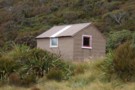
Waikiti hut Jan 2009
Photograph
•
Distance: 9.3km away
Situated in the headwaters of the Waikiti River a major tributary of the Ahaura River.
More ▶︎
Waikiti hut
Hut
•
Basic Hut/Bivvy (DOC). Capacity: 6.
•
Distance: 9.3km away
This hut is situated in the headwaters of the Waikiti river on a flat that is partly grass but largely ...
More ▶︎
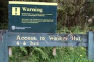
DOC Warning Sign Jan 2009
Photograph
•
Distance: 9.3km away
We saw this sign in early 2008 when returning from another trip and thought we must have a crack at ...
More ▶︎

Arthur's Pass National Park
Place
•
National Park. 1145.00km2.
•
Distance: 9.4km away
This alpine park straddles the Main Divide of the Southern Alps, with dry beech forests in the east and damp ...
More ▶︎
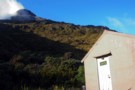
Townsend hut March 2009
Photograph
•
Distance: 9.5km away
Townsend hut which is perched high above the TL of the Taramakau River in the scrub - tussock transition zone ...
More ▶︎
Townsend hut
Hut
•
Basic Hut/Bivvy (DOC). Capacity: 4.
•
Distance: 9.5km away
Townsend hut which is perched high above the TL of the Taramakau River in the scrub - tussock transition zone ...
More ▶︎
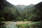
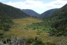
Looking west over Rochfort Basin
Photograph
•
Distance: 9.6km away
No.3 of the access routes described on the hut page for Waikiti hut crosses this basin. Crane Creek which drains ...
More ▶︎
Townsend Hut
Photograph
•
Distance: 9.7km away
Early morning, heading for Lake Minchin to meet the 'Chuzzman' aka 'chuzz'.
More ▶︎
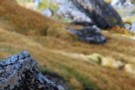
Peak a chamois - Townsend Tops
Photograph
•
Distance: 9.9km away
Occasionally when walking between Townsend hut and Minchin pass you may play peak a boo with the wildlife.
More ▶︎