Nearby
Te Kahui Kaupeka Conservation Park
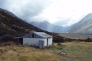
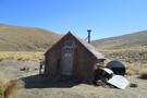
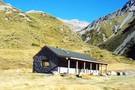
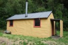
Growler Hut
Photograph
•
Distance: less than 100m away
A new DOC Hut in the Havelock Valley (formally privately owned). Located on the true right of the Havelock just ...
More ▶︎
Growler Hut
Hut
•
Standard Hut (DOC). Capacity: 8.
•
Distance: less than 100m away
Growler Hut is located on the south side of the Havelock River valley, just upriver of the Growler Stream. It's ...
More ▶︎
Picton to Aspiring
GPX file
•
Distance: less than 100m away
An aborted alpine traverse. Picton to West Cape, but aborted at Aspiring due to real world emergencies back home. Posted ...
More ▶︎
Havelock River to MacAuley River
GPX file
•
Distance: less than 100m away
route taken from Growler Hut, Havelock River to MacAuley Hut, Macauley River via Growler Creek, Balaclava Col, Plata Col & ...
More ▶︎
Crooked Spur Hut
Hut
•
Basic Hut/Bivvy (DOC). Capacity: 8.
•
Distance: less than 100m away
A beech-pole hut constructed 1947, and located about 1 hour's climb above the streambed of Bush Stream near Mesopotamia. Used ...
More ▶︎
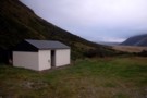
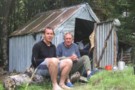
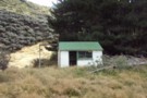
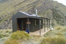
Growler Hut
Photograph
•
Distance: less than 100m away
Growler Hut, a private hut on the south side of the Havelock.
More ▶︎

Route Guide: Otira to Mt Cook Village (pt 1)
Track
•
12 – 21 days. Hard. One way.
•
Distance: less than 100m away
One possible route down the main divide from Otira on the Arthur's Pass road to Mt Cook Village.
Otira Hotel to ...
More ▶︎

Route Guide: Otira to Mt Cook Village (pt 2)
Track
•
12 – 21 days. Hard. One way.
•
Distance: less than 100m away
One possible route down the main divide from Otira on the Arthur's Pass road to Mt Cook Village.
Otira Hotel ...
More ▶︎
Crossing the Clyde and Havelock - brushes with the Canterbury Death
Article
•
Distance: less than 100m away
High rivers ... lessons learnt.
Day 11 of the Otira to Mt Cook leg of my Southern Traverse
More ▶︎
Red Stag Hut
Hut
•
Basic Hut/Bivvy (NZDA). Capacity: 6.
•
Distance: 105m away
NZDA hut on the true left of the Godley River. This hut can be driven to with a 4WD.
More ▶︎
Veil Biv
Hut
•
Basic Hut/Bivvy (NZDA). Capacity: 3.
•
Distance: 291m away
This biv is located at the confluence of Veil Stream with the Havelock River. It was moved to a new ...
More ▶︎
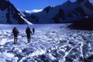
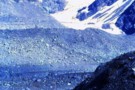
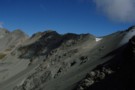
The Growler (creek)
Photograph
•
Distance: 356m away
The Growler (creek), from the confluence with the Havelock, near Growler Hut.
More ▶︎
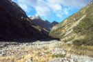
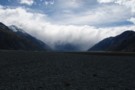
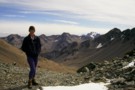
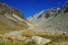
At Veil Stream
Photograph
•
Distance: 367m away
the havelock valley finally starts to narrow down
More ▶︎
Dog Kennel Hut
Photograph
•
Distance: 2.2km away
Basic hut, Rangitata watershed, no bunks, fireplace outside.
More ▶︎
Dog Kennel Bivvy
Hut
•
Basic Hut/Bivvy (DOC).
•
Distance: 2.2km away
Basic hut, no bunks, dirt floor, but still good shelter. Fireplace outside.
More ▶︎
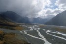
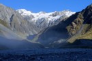
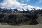
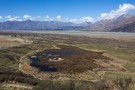
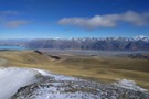
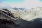
Havelock Valley
Photograph
•
Distance: 2.3km away
Havelock Valley, from just below The Growler (creek). The private Growler Hut is on the flats on the left beyond ...
More ▶︎
Eric Bivvy
Hut
•
Basic Hut/Bivvy (Canterbury Mountaineering Club).
•
Distance: 2.5km away
A tidy historical shelter located on Agony Island near St Winifred Hut. Currently, the hut is great for shelter especially ...
More ▶︎
Ayres Hut (Removed)
Hut
•
Removed!
•
Distance: 2.9km away
Restored 4 bunk hut one hour up Black Birch Stream, Mesopotamia, in Two Thumb Range. As of 2012, DOC reports ...
More ▶︎
Eade Memorial Hut
Hut
•
Private hut (NZDA). Capacity: 6.
•
Distance: 2.9km away
NZDA hut located moraine, on the true left of the Godley River, close to a number of glaciers and lakes.
More ▶︎
Forest Creek. Bullock Bow Saddle, Bush Stream circuit
Track
•
2 – 4 days. Medium. Loop track with a road section.
•
Distance: 3.1km away
3 day circuit (1 full day) involving retired pastoral lease runs. Middle section especially attractive as it traverses unfolding rolling ...
More ▶︎
Stone Hut (Canterbury)
Hut
•
Basic Hut/Bivvy (DOC). Capacity: 8.
•
Distance: 3.3km away
This historic hut is constructed of stone and corrugated iron, and located in Forest Creek. The first stone hut on ...
More ▶︎
St Winifreds Hut
Hut
•
Standard Hut (Canterbury Mountaineering Club). Capacity: 9.
•
Distance: 3.3km away
Iron hut owned by the Canterbury Mountaineering Club. The hut was built in 1959 to replace the old Havelock Hut. ...
More ▶︎
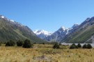
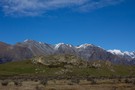
View from St Winifreds Hut
Photograph
•
Distance: 3.3km away
The mountains around the upper havelock river from the front of st winifred's hut.
More ▶︎
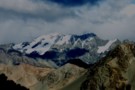
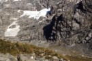
Mount Sibbald
Photograph
•
Distance: 3.5km away
Mount Sibbald, from the col between Lower Tindall Stream and North Branch. An short day walk from the nearby Macauley ...
More ▶︎
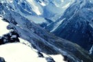
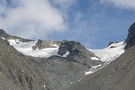
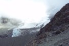
Godley Glacier 5 am
Photograph
•
Distance: 3.8km away
Walking up the Godley Glacier at 5 am en route to the Stewart Saddle which is at the head of ...
More ▶︎
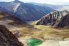
Tarns, Lower Tindall Stream
Photograph
•
Distance: 3.8km away
Tarns at the head of the Lower Tindall Stream, above Macauley Hut.
More ▶︎
Separation Stream
Photograph
•
Distance: 5.0km away
Separation Stream is on the true left of the Godley River not far downstream from the Godley Hut. The ridge ...
More ▶︎
Forbes Bivvy
Hut
•
Basic Hut/Bivvy (DOC). Capacity: 2.
•
Distance: 5.4km away
Bivouac located on the Forbes River flats beneath the Two Thumb Range.
More ▶︎
Rankin Hut
Hut
•
Private hut (PVT). Capacity: 6.
•
Distance: 5.4km away
Rankin Hut (private, 6 bunks. mattresses, wood-burning cooking stove, firewood available, stream water) is a station hut on the flats ...
More ▶︎
Rankin Hut
Photograph
•
Distance: 5.4km away
Rankin Hut- a private station hut in the Godley Valley
More ▶︎
Alma Col
Photograph
•
Distance: 5.5km away
Technically easy but long pass between Rangitata and Macauley watersheds.
More ▶︎
Upper Perth River
Photograph
•
Distance: 5.5km away
Headwaters of the Perth taken from near The Great Unknown. Garden of Eden Plateau high on the left
More ▶︎
Camp Stream Hut
Hut
•
Basic Hut/Bivvy (PVT). Capacity: 6.
•
Distance: 5.7km away
A small, dark hut in good condition, owned by the Mackenzie Alpine Trust, and free to use. Donations are appreciated. ...
More ▶︎
Carney's Bivvy No. 2
Hut
•
Basic Hut/Bivvy (DOC). Capacity: 2.
•
Distance: 5.9km away
One of two side-by-side huts in the Two Thumb Range.
More ▶︎
Carney's Bivvy No. 1
Hut
•
Basic Hut/Bivvy (DOC). Capacity: 2.
•
Distance: 5.9km away
One of two side-by-side huts in the Two Thumb Range.
More ▶︎
Godley Hut
Hut
•
Standard Hut (NZAC). Capacity: 8.
•
Distance: 6.0km away
Historic hut opened 24 December 1934. This hut is located above Fitzgerald Stream at the head of the Godley Valley, ...
More ▶︎
Godley Hut
Photograph
•
Distance: 6.0km away
Godley hut 1969. The hut was quite close to the terminal face of the Godley Glacier then, but the end ...
More ▶︎
Macauley Hut
Photograph
•
Distance: 6.1km away
Macauley Hut, a luxurious public hut in the Macauly valley.
More ▶︎

Macaulay Hut
Hut
•
Serviced Hut (Mackenzie Alpine Trust). Capacity: 14.
•
Distance: 6.1km away
Macaulay Hut (14 bunks, matresses, stove, firewood provided, water, bath, mountain radio, gas cookers, lighting) is a luxury option for ...
More ▶︎
Upper Macauley Valley
Photograph
•
Distance: 6.1km away
Upper Macauley Valley from Macauley Hut.
More ▶︎
Scone Basin
Photograph
•
Distance: 6.1km away
While exploring the Scone Basin the fog briefly rolled back to reveal Mt Shyness.
More ▶︎
Plata Col from Balaclava Saddle
Photograph
•
Distance: 6.2km away
The sidle to Plata Col from the Balaclava saddle at the head of the Growler.
More ▶︎
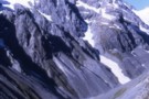
Balaclava Saddle
Photograph
•
Distance: 6.2km away
The ascent to Balaclava Saddle between The Growler (Havelock) and NE Gorge Creek (McCauley). The saddle is a good alpine ...
More ▶︎
Bettison Stream
Photograph
•
Distance: 6.2km away
Campsite in the upper Bettison 1969 /70. Very little in the way of maps or information then. Came over the ...
More ▶︎
Richmond hut (Te Kahui Kaupeka)
Hut
•
Shelter (DOC).
•
Distance: 6.4km away
A tiny mustering hut high on Bush Stream. The hut is old, with signatures dating back to 1896. It is ...
More ▶︎
Curtis Memorial Hut
Hut
•
Standard Hut (DOC). Capacity: 4.
•
Distance: 6.8km away
Hut on the Havelock River opposite the confluence of the Forbes.
More ▶︎
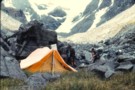
Scone Basin
Photograph
•
Distance: 6.8km away
The impressive cliffs of Mt Ariki and Mt McKinnon tower over our humble little tent fly in the Scone Basin, ...
More ▶︎
Mistake Flat Hut
Hut
•
Standard Hut (DOC). Capacity: 6.
•
Distance: 6.9km away
Hut on the Mistake Flats, where the Forbes meets the Havelock River.
More ▶︎
Murphy's Bivvy
Hut
•
Standard Hut (DOC). Capacity: 2.
•
Distance: 6.9km away
Small hut below the Murphy Glacier on the Two Thumb Range.
More ▶︎
Adams Wilderness Area
Place
•
Wilderness Area. 465.87km2.
•
Distance: 7.0km away
This wilderness area includes the Adams and Wilberg Ranges behind Harihari, through to the Butler Range east of the Main ...
More ▶︎
Sibbald Range
Photograph
•
Distance: 7.2km away
Sibbald Range from Plata Col. This is an alpine route between the Havelock and Macauley via either Camp Creek, or ...
More ▶︎

Te Araroa Trail
Track
•
95 days. Medium. One way.
•
Distance: 7.3km away
Te Araroa is a walking trail running the entire length of the North and South Islands. The trail opened 3 ...
More ▶︎
Bettison Stream & Dennistoun Pass Feb 2011
Photograph
•
Distance: 7.4km away
This pic taken by Neil B with my camera shows two old crusties above the bush line on the Bettison ...
More ▶︎
McCoy Hut
Hut
•
Standard Hut (DOC). Capacity: 6.
•
Distance: 7.8km away
McCoy hut is a six bunk hut located on the confluence of Franceis River and McCoy Stream, which flows down ...
More ▶︎
Rex Simpson Hut
Hut
•
Private hut (PVT). Capacity: 6.Bookings required.
•
Distance: 7.9km away
This hut located at the top edge of a terrace above Lake Tekapo. It is owned by Alpine Recreation and ...
More ▶︎
Royal Hut
Hut
•
Basic Hut/Bivvy (DOC). Capacity: 8.
•
Distance: 8.2km away
An old mustering hut located in the broad tussock basin of Bush Stream. Originally called "New Hut", its name changed ...
More ▶︎
Whitcombe Pass & Butler Saddle
Article
•
Distance: 9.0km away
route guide attached by for Hokitika Gorge to Erewhon via Whitcombe Pass & Butler Saddle. The guide was written by ...
More ▶︎
Watchdog Hut
Hut
•
Standard Hut (DOC). Capacity: 6.
•
Distance: 9.0km away
Located on the true right back of the Clyde River beneath Watchdog Peak.
More ▶︎
Murchison Hut
Hut
•
Serviced Alpine Hut (NZAC). Capacity: 10.
•
Distance: 9.1km away
This hut sits high above the Muchison Glacier.
More ▶︎
Scone hut
Hut
•
Standard Hut (DOC). Capacity: 6.
•
Distance: 9.1km away
This hut is situated near the confluence of Scone Creek and the Perth River & is on the TL of ...
More ▶︎
Scone hut Feb 2011
Photograph
•
Distance: 9.1km away
This hut is situated near the confluence of Scone Creek and the Perth River & is on the TL of ...
More ▶︎
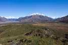
Havelock and Clyde Rivers from Mount Sunday
Photograph
•
Distance: 9.2km away
To the right is Newton Peak (2543m) between the Garden of Eden and Garden of Allah Ice Plateaux, and overlooking ...
More ▶︎
Mount Sunday Wetland
Photograph
•
Distance: 9.2km away
Fenced wetland on the Rangitata Riverbed, managed by Environment Canterbury. The wetland was fenced early 2013, and already in just ...
More ▶︎
Mount Sunday, Rangitata River
Track
•
Easy. Return by the same track.
•
Distance: 9.2km away
Short walk to a roche moutonnée, a rocky outcrop in the Rangitata River channel. The hill was used as the ...
More ▶︎
Glacial scratches on the summit of Mount Sunday
Photograph
•
Distance: 9.2km away
Mount Sunday was once underneath the Rangitata Glacier, and these scratches remain from rocks being dragged over the summit.
More ▶︎
Erewhon Station - Garden Of Eden - Perth River - Whataroa
Track
•
5 – 7 days. Hard. One way.
•
Distance: 9.3km away
Erewhon Station, McCoy Hut, Wee MacGregor Glacier, Garden Of Eden, Adverse Creek, Perth River, Whataroa
More ▶︎
Pt 1944 Down Ridge of Beuzenberg Peak
Photograph
•
Distance: 9.3km away
Looking out over the Godley River and the head of Lake Tekapo
More ▶︎
Mount Sunday
Photograph
•
Distance: 9.8km away
Little Mount Sunday (611m) is a roche moutonnée in the Rangitata Riverbed. Behind is the Black Mountain Range.
More ▶︎
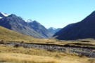
The Havelock
Article
•
Distance: 9.9km away
The Havelock River is one of the six great Canterbury rivers. As shown in Mathew's photo above, the peaks rise ...
More ▶︎
Rankin Pass
Photograph
•
Distance: 9.9km away
Technically easy, few hours from Rankin Hut in Godley. Few more hours down to Cass Memorial Hut.
More ▶︎
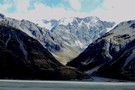
Huxley Glacier
Photograph
•
Distance: 9.9km away
The Huxley Glacier, in the upper Cass River - seen from Rankin Pass.
More ▶︎
Rankin Stream / Rankin Pass
Photograph
•
Distance: 9.9km away
Rankin Stream from the Godley River flats. The notch on the left of the valley is the Rankin Pass, a ...
More ▶︎
Cass River, East Branch
Photograph
•
Distance: 9.9km away
The head of the Cass river from Rankin Saddle. The Huxlrey glacier descends into the western half of the valley ...
More ▶︎
South Opuha Hut
Hut
•
Private hut (Mackenzie Alpine Trust). Capacity: 6.
•
Distance: 10.0km away
This hut was completed November 2013, replacing an old DOC hut. It is located on a terrace at the confluence ...
More ▶︎
Huxley Glacier
Photograph
•
Distance: 10.0km away
The Huxley Glacier, descending from Mt Hutton into the upper Cass Valley. The private Rankin and Memorial Huts nearby provide ...
More ▶︎