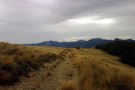
Nearby
Tablelands Circuit
Balloon Hut
Photograph
•
Distance: 1.5km away
5 star accommodation, gas burner & cooker provided!! Approxmately 4 hr from Trilobite Hut
More ▶︎
Mt Arthur Hut - Salisbury Lodge
Track
•
Easy/medium. One way.
•
Distance: 1.5km away
via Gordons Pyramid
More ▶︎
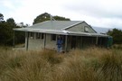
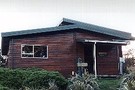
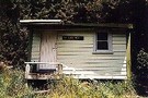
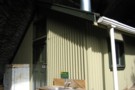
Salisbury Lodge
Photograph
•
Distance: 1.5km away
from Gordon's Pyramid, the hut looks deceptively close - Apr 2011
More ▶︎
Leslie-Karamea
Track
•
3 – 4 days. Medium. One way.
•
Distance: 1.6km away
Joins onto Wangapeka Track.
More ▶︎
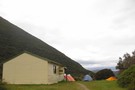
Salisbury Lodge
Hut
•
Serviced Hut (DOC). Capacity: 22.
•
Distance: 1.6km away
A big beautiful hut. Four large sleeping platforms with mattresses. Gas cookers (2 sets of 4 rings) and 2 gas ...
More ▶︎
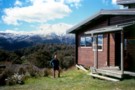
Salisbury Lodge looking toward Mt Arthur
Photograph
•
Distance: 1.6km away
My great-great-grandfather herded 400 sheep & cattle here on the Tablelands from 1875 til 1920, once he obtained the grazing ...
More ▶︎
Balloon Hut
Hut
•
Serviced Hut (DOC). Capacity: 14.
•
Distance: 1.8km away
Gas cooker and heater. Great views of the Arthur Range and over the headwaters of the Leslie River (from Balloon ...
More ▶︎
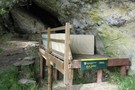
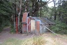
Dry Rock Shelter
Hut
•
Natural shelter (DOC). Capacity: 3.
•
Distance: 2.5km away
Dry Rock Shelter. An open air shelter under a rock overhang, but with a sleeping platform and mattresses.
More ▶︎
Mt Arthur to Murchison
GPX file
•
Distance: 2.8km away
track from Mt Atrhur Tablelands to Murchison via Wangapeka Saddle, Nugget Knob and the Matiri Valley
More ▶︎
Splugeons Rock Shelter
Hut
•
Basic Hut/Bivvy (DOC). Capacity: 5.
•
Distance: 3.0km away
A great hut built into a natural rock shelter. Water available from a nearby stream.
More ▶︎
Spludgeons Shelter
Photograph
•
Distance: 3.0km away
Capacity 5 - earthen floor, heavy plastic roll-up for main wall (lashed down when this photo taken - Apr 2011)
More ▶︎
Spludgeon Shelter
Photograph
•
Distance: 3.0km away
front of the shelter, with view into the Leslie River - Apr 2011
More ▶︎
Cloustons Mine Track
Track
•
Easy/medium. One way.
•
Distance: 4.2km away
Leading from the Salisbury Track on Flora Stream up past Cloustons Mine to Gordons Pyramid (1489m).
More ▶︎
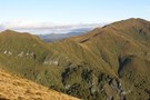
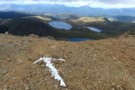
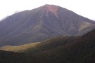
Gordons Pyramid
Photograph
•
Distance: 4.2km away
From the Mt Arthur track, showing the poled route over point 1380 (left of pic) to the summit of Gordons ...
More ▶︎
Approach to Gordons Pyramid
GPX file
•
Distance: 4.2km away
The actual track (the BQ24-Tapawera map is incorrect) from the Mt Arthur Track to Gordons Pyramid
LINZ have indicated they will ...
More ▶︎
Gordons Pyramid
Place
•
Place.
•
Distance: 4.2km away
1489m, Kahurangi NP, between Mt Arthur and the Arthur Tableland
More ▶︎
Lake Peel
Track
•
1 day. Easy/medium. Return by the same track.
•
Distance: 4.2km away
Pleasant walk to an alpine lake in the Cobb Valley.
More ▶︎
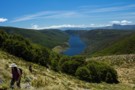
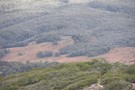
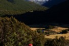
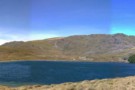
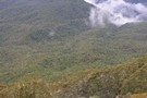
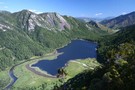
The route to Lake Peel
Photograph
•
Distance: 4.5km away
The Cobb Reservoir fills the glacial valley.
More ▶︎
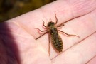
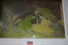
Dragonfly nymph
Photograph
•
Distance: 4.7km away
Floating in Lake Peel, in the Cobb Valley.
More ▶︎
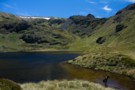
Lake Peel
Photograph
•
Distance: 4.7km away
Pretty, circular lake in Kahurangi National Park.
More ▶︎
Myttons Hut
Hut
•
Basic Hut/Bivvy (DOC). Capacity: 4.
•
Distance: 5.1km away
Four bunks with mattresses. Water from tap outside - possibly from nearby creek.
From 1994, DOC have stopped maintaining this quaint ...
More ▶︎
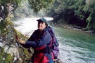
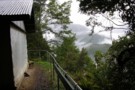
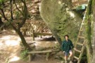
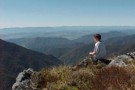
View from Myttons Hut, looking up Cobb Valley
Photograph
•
Distance: 5.1km away
Lynette Salisbury on the Cobb. Distant peaks at valley head are Xenicus Peak & Aorere Peak.
More ▶︎
Lower Gridiron Shelter
Hut
•
Basic Hut/Bivvy (DOC). Capacity: 4.
•
Distance: 5.1km away
4 person hut bivvy under rock overhang
More ▶︎
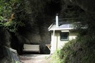
Lower Gridiron Shelter
Photograph
•
Distance: 5.1km away
Lower Gridiron shelter. taken 18-Mar-2006
More ▶︎
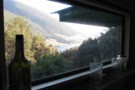
Upper Gridiron picture window
Photograph
•
Distance: 5.6km away
The picture window above the door at Upper Gridiron hut. taken Mar 2006
More ▶︎
Upper Gridiron Hut
Hut
•
Standard Hut (DOC). Capacity: 3.
•
Distance: 5.6km away
Half hut and half rock overhang -- a most unusual place.
More ▶︎
Cobb River campsite
Campsite
•
Informal campsite (DOC). 20 spaces.
•
Distance: 5.9km away
Camping on grassy river flats in the Cobb Valley. Ample walking options in the area.
More ▶︎

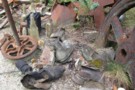
The Fridge that used to be at Upper Gridiron Shelter
Photograph
•
Distance: 5.9km away
Not there anymore.
More ▶︎
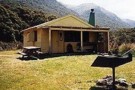
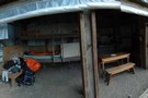
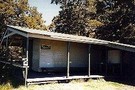
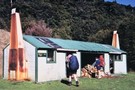
Trilobite Hut
Hut
•
Standard Hut (DOC). Capacity: 12.
•
Distance: 6.0km away
A large road-end hut. Picnic table and barbecue outside.
More ▶︎
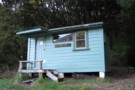
Trilobite Hut
Photograph
•
Distance: 6.0km away
cosy hut with log fire, easy access, good starting point to explore the area.
More ▶︎
Cobb Valley
Track
•
2 days. Easy. Return by the same track.
•
Distance: 6.1km away
A beautiful, easy tramp for beginners. The valley had many grassy flats so there are wonderful views all the way. ...
More ▶︎
Mt Arthur
Track
•
1 – 2 days. Easy/medium. Return by the same track.
•
Distance: 6.3km away
Straightforward climb to the summit of Mt Arthur (1795m) on the Arthur Range.
More ▶︎
North Twin Kahurangi
GPX file
•
Distance: 6.7km away
This route branches off of the Ellis Hut - South Twin route (see elsewhere on this site) about 45 mins ...
More ▶︎
Kahurangi Park - The Twins
GPX file
•
Distance: 6.9km away
This route leads from the Ellis Hut to the west side of South Twin. It's an exciting walk through some ...
More ▶︎

Cobb Reservior from Lookout
Photograph
•
Distance: 7.0km away
view on the way to Balloon Hut.
More ▶︎
Mt Arthur Hut
Track
•
0 – 2 days. Easy/medium. Loop track.
•
Distance: 7.3km away
Easy loop to a hut at the bushline of the Arthur Range.
More ▶︎
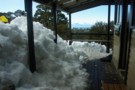
Mt.Arthur hut in snow Sept 2010
Video
•
Distance: 7.3km away
A cold but fun stay over in the Kahurangi National Park.
More ▶︎
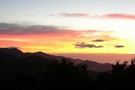
Sunrise from Mt Arthur Hut
Photograph
•
Distance: 7.3km away
A crowded hut means an early start - Apr 2011
More ▶︎
Mt. Arthur Hut
Hut
•
Serviced Hut (DOC). Capacity: 8.
•
Distance: 7.3km away
Nice little hut popular with day-trippers from Flora carpark. Gas stove and heater. Allows an interesting 5 hour excursion up ...
More ▶︎
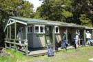
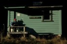
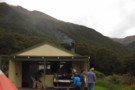
Mt Arthur Hut
Photograph
•
Distance: 7.3km away
A popular rest point on the way to climb Mt Arthur. Some people here are actually staying the night at ...
More ▶︎
Ellis Hut
Hut
•
Standard Hut (DOC). Capacity: 6.
•
Distance: 7.7km away
Hut on a tributary of the Ellis River, on the flanks of the Arthur Range. A route continues past the ...
More ▶︎
Ellis Hut / Murderer's Hut (Hawke's Bay)
Hut
•
Private hut (DOC).
•
Distance: 7.7km away
This is a historic hut which is available for recreational use. The hut was built 1884 for Poporangi Station, and ...
More ▶︎
Asbestos Cottage
Hut
•
Basic Hut/Bivvy (DOC). Capacity: 4.
•
Distance: 7.7km away
A quaint hut with history - some of the original occupant's belongings still present and in use.
Asbestos Cottage was ...
More ▶︎
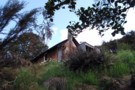
Asbestos Cottage
Photograph
•
Distance: 7.7km away
First view as you come out of the bush into the clearing
More ▶︎
Ellis Basin Hut
Hut
•
Standard Hut (DOC). Capacity: 6.
•
Distance: 7.7km away
A six bunk hut hiding at the bottom of the Ellis Basin on the south side of Mt Arthur. Caving ...
More ▶︎
Asbestos Track
Track
•
0 – 1 day. Easy/medium. Return by the same track.
•
Distance: 7.8km away
A gently graded mine road climbing to an asbestos mine and 1890s cottage.
More ▶︎
Wilkinson Track
Track
•
1 day. Medium. One way.
•
Distance: 8.1km away
Cleared by DoC in November 2011, the lower third of the track is now easily climbed. Above this, the track ...
More ▶︎
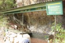
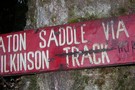
Wilkinson Track sign
Photograph
•
Distance: 8.1km away
At the bottom of the track, this sign remembers conditions from several years ago – DOC cleared the track in ...
More ▶︎
Flora Hut
Hut
•
Basic Hut/Bivvy (DOC). Capacity: 12.
•
Distance: 8.2km away
An old hut in a large clearing 35 minutes from Flora Carpark, built around the 1920s. It is seldom stayed ...
More ▶︎
Flora Hut Walk
Track
•
Easy. Return by the same track.
•
Distance: 8.3km away
Easy walk over Flora Saddle to Flora Hut. This is a good family walk, but the hut is basic. There ...
More ▶︎
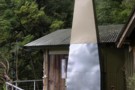
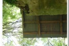
Looking up at the corrugated iron overhang
Photograph
•
Distance: 8.3km away
Must to have been fun putting that up!
More ▶︎

Flora Huts
Photograph
•
Distance: 8.3km away
Long before the road was pushed up the Graham Valley, hikers had to leave the old Salisbury farm at Pokororo. ...
More ▶︎
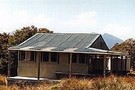
Lake Sylvester Hut
Photograph
•
Distance: 8.4km away
Replacement/ Upgrade of "Bushline Hutt"
More ▶︎
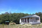
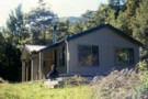
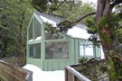
Sylvester Hut
Photograph
•
Distance: 8.5km away
Sylvester Hut as you return from Lake Sylvester. (better photographs invited ;)
More ▶︎
Sylvester Hut
Hut
•
Serviced Hut (DOC). Capacity: 12.
•
Distance: 8.5km away
Modern 12 bunk hut with heater (not stove), bench seating and two sleeping platforms with a sink and two toilets ...
More ▶︎
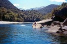
Karamea River
Photograph
•
Distance: 8.9km away
The legendary Karamea flows north, then suddenly turns west out to sea, (through grade 5 whitewater & a notorious gorge). ...
More ▶︎
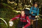
Leslie-Karamea Track
Photograph
•
Distance: 8.9km away
A moderate 7-9-day tramp thru the heart of Kahurangi National Park, for experienced trampers with good gear and skills.
More ▶︎
Karamea Bend Hut
Photograph
•
Distance: 8.9km away
Sited adjacent to the Leslie River, this big barn is harder to heat.
More ▶︎
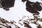
The Way Down
Photograph
•
Distance: 9.0km away
If you're heading S along the Lockett Range, don't worry about where to descend to Lake Sylvester - it's pretty ...
More ▶︎
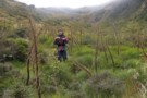
at the top of Wilkinson Track
Photograph
•
Distance: 9.2km away
above the tree-line, Wilkinson Track requires a push through Spaniard grass followed by a steep climb to Baton saddle – ...
More ▶︎
Loveridge Hut
Article
•
Distance: 9.2km away
An overnight trip to a less-used hut in Kahurangi National Park.
More ▶︎
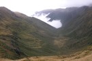
Baton Valley
Photograph
•
Distance: 9.3km away
looking S from Baton Saddle, Flanagan’s Hut is on the edge of the valley cloud, a very steep descent and ...
More ▶︎
Baton Valley Track
Track
•
Easy/medium. One way.
•
Distance: 9.3km away
From Baton Saddle, the route follows snow-poles steeply down to the valley floor through Spaniard grass thickets (not the most ...
More ▶︎
Baton Saddle
Photograph
•
Distance: 9.3km away
from Baton Saddle, looking N across the top of Wilkinson’s Track into the Leslie Valley – Apr 2011
More ▶︎
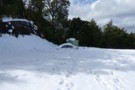
Flora Carpark Snowed in Car
Photograph
•
Distance: 9.4km away
A car believed to have been left behind from a party rescued from Mt Arthur/Flora area recently to my trip ...
More ▶︎
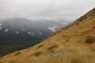
Descent from Baton Saddle
Photograph
•
Distance: 9.5km away
following the pole-line from Baton Saddle doesn’t avoid the Spaniard grass ! – Apr 2011
More ▶︎
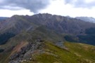
Lockett Range
Photograph
•
Distance: 9.5km away
looking N along the Lockett Range to Mt Benson -
from Iron Hill
Feb 2017
More ▶︎
Wangapeka Tramp
Photograph
•
Distance: 9.7km away
Large lump of quartz in Kahurangi National Park
More ▶︎
Lodestone
Track
•
1 day. Medium. Loop track.
•
Distance: 9.7km away
A track leading to the summit of Lodestone, a peak north of the popular Mt Arthur. The easiest route follows ...
More ▶︎
Flora Shelter - Kahurangi Nat Pk.
Photograph
•
Distance: 9.8km away
Flora Shelter in the Kahurangi National Park. Lovely spot but bugger to get to in snow without 4wd!
More ▶︎
Kahurangi National Park
Place
•
National Park. 4520.02km2.
•
Distance: 9.8km away
New Zealand's second largest, and youngest national park, dating from 1996. A large area of land at the top of ...
More ▶︎