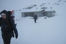
Nearby
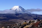
Tongariro National Park
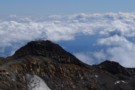
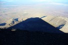
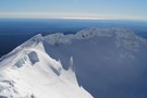
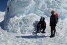
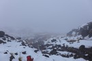
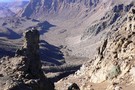
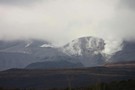
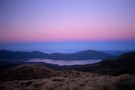
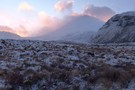
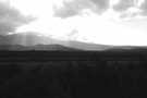
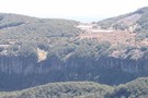
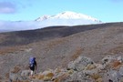
Glacier Knob, Mt Ruapehu
Photograph
•
Distance: less than 100m away
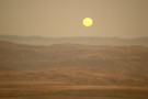
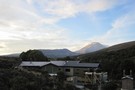
Early Autumn and Ruapehu is a completely different beast - take the lazy chairlift option and you'll summit in under ...
More ▶︎
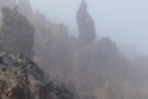
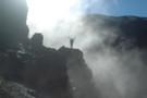
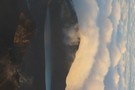
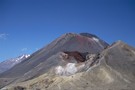
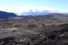
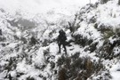
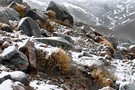
Lava in the mist
Photograph
•
Distance: less than 100m away
Low cloud obscured the views on the trail to the Mt Tongariro summit, but resulted in lava formations looming eerily ...
More ▶︎
Tongariro National Park World Heritage Area
Place
•
World Heritage Area. 795.96km2.
•
Distance: less than 100m away
Tongariro National Park was given to the Crown by the Ngati Tuwharetoa iwi in 1887, and became New Zealand's first ...
More ▶︎
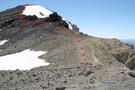
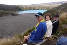
The ridge to Dome shelter on Ruapehu
Photograph
•
Distance: less than 100m away
A couple of people about a half hour behind, move along to the Dome shelter overlooking Ruapehu's crater lake. December ...
More ▶︎
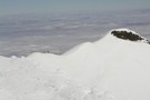
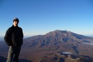
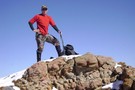
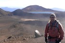
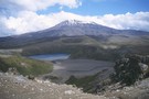
Ruapehu Summit Dec 2002
Photograph
•
Distance: less than 100m away
First time on Ruapehu with the ski season still going in Dec.
A stark contrast to a visit 3 mths ...
More ▶︎
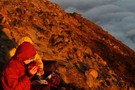
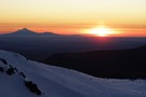
Warming Up on Ngauruhoe
Photograph
•
Distance: less than 100m away
After a cold night, the sunrise from the heated summit of ngauruhoe is incredible. Enjoying a well earned brew high ...
More ▶︎
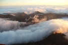
Tongariro Massif at Dawn
Photograph
•
Distance: less than 100m away
From the summit of Ngauruhoe, the clouds flow past the summits of Tongariro. Not a tourist in sight! A full ...
More ▶︎
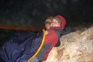
Waiting for the sun, Ngauruhoe
Photograph
•
Distance: less than 100m away
A midnight tramp under the moonlight, up through the clouds takes you to the summit of ngauruhoe, where the hot ...
More ▶︎
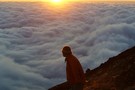
Ngauruhoe Sunrise
Photograph
•
Distance: less than 100m away
A midnight tramp under the moonlight, up through the clouds takes you to the summit of ngauruhoe, where the hot ...
More ▶︎
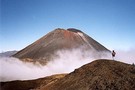
Ngauruhoe Summit
Photograph
•
Distance: less than 100m away
Early morning, lower tama lake full of mist
More ▶︎
DzungN
Photograph
•
Distance: less than 100m away
Round the Mountain, Mt Ruapehu, late Febuary 2003
More ▶︎
Ruapehu
Photograph
•
Distance: less than 100m away
The mountain from Urchin in the Kaimanawas october 2006
More ▶︎
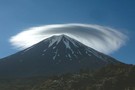
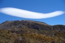
St Ngauruhoe blessing the trampers
Photograph
•
Distance: less than 100m away
As the sun rose we were greeted with this curious spectacle of a lenticular cloud wrapped about the cone of ...
More ▶︎
Hiking the Tongariro Northern Circuit
Article
•
Distance: less than 100m away
The Tongariro Northern Circuit circles around Ngauruhoe's cone with chances to climb either Ngauruhoe or Tongariro. The entire circuit takes ...
More ▶︎
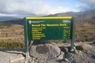
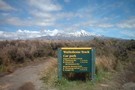
Mount Tongariro
Track
•
Easy/medium. Return via same route.
•
Distance: less than 100m away
A side trip on the Tongariro Crossing to the low summit of Tongariro Volcano
More ▶︎
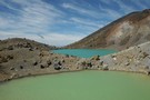
Emerald Lakes - Tongariro
Photograph
•
Distance: less than 100m away
From tongariro Crossing
More ▶︎
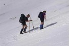
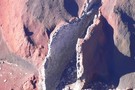
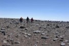
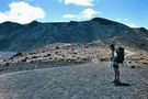
My Efforts Flailing in the Snow
Photograph
•
Distance: less than 100m away
If you squint you can see where I tumbled into the powder-bowl and had to zig-zag back up... Being substantially ...
More ▶︎
Late on the mountain
Photograph
•
Distance: less than 100m away
After a long day's walking/climbing we were treated to a lovely sunset over the New Plymouth coast with Mt Egmont ...
More ▶︎
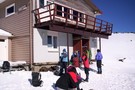
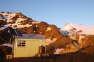
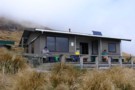
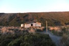
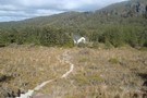
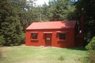
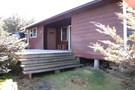
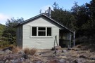
Hutt Valley Tramping Club lodge Mt Ruapehu
Photograph
•
Distance: less than 100m away
H.V.T.C lodge Mt Ruapehu
More ▶︎
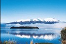
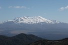
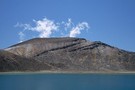
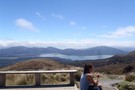
ruapehu mountain
Photograph
•
Distance: less than 100m away
a beautiful mountain taken from lake Rotoira
More ▶︎
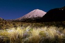
Mount Ngauruhoe
Photograph
•
Distance: less than 100m away
Ngauruhoe viewed from South Crater, Tongariro Alpine Crossing.
More ▶︎
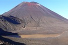
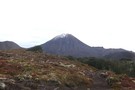
Ngauruhoe Volcano
Track
•
1 day. Medium. Returns via same track.
•
Distance: 182m away
Ascent of the steep, symmetrical scoria cone of a young volcano - can be walked as a 3 hour side ...
More ▶︎
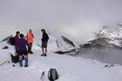
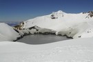
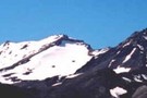
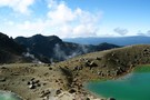
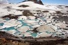
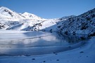
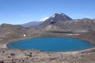
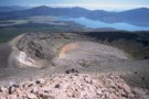
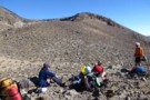
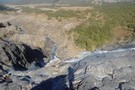
Looking out over the Crater Lake
Photograph
•
Distance: 223m away
We arrived at the edge of the crater lake. It was too icy to get up to Dome Shelter
More ▶︎
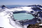
Mt Ruapehu Crater Lake
GPX file
•
Distance: 323m away
This trip goes up to the Crater Lake from the Top of the Bruce and then comes down via the ...
More ▶︎
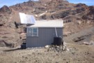
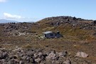
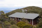
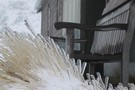
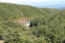
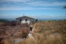
Dome Shelter, Mt Ruapehu
Photograph
•
Distance: 466m away
Entry fee : 1 ice axe and an hour's chipping away....
More ▶︎
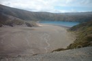
Crater Lake - Mount Ruapehu
Photograph
•
Distance: 466m away
View of Crater Lake from Dome Shelter - January 1st 2011.
More ▶︎
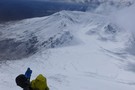
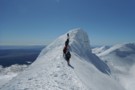
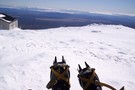
Winter ascent - Mt Ngauruhoe
Photograph
•
Distance: 902m away
70kph winds and swirling spindrift made for an interesting climb. Unfortunately we were turned back 50m from the summit by ...
More ▶︎
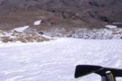
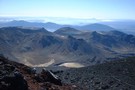
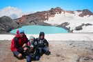
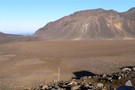
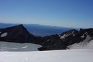
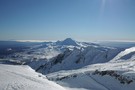
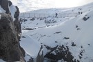
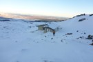
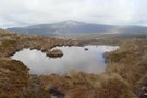
Summit Plateau - Mount Ruapehu
Photograph
•
Distance: 1.1km away
A view from Glacier Knob of Summit Plateau looking SW towards Cathedral Rocks. January 1st 2011.
More ▶︎
Above the Ruapehu summit plateau
Photograph
•
Distance: 1.2km away
Heading north towards the notch. Fantastic day for it!
More ▶︎
South Crater
Photograph
•
Distance: 1.3km away
South Crater viewed from the eastern rim, Tongariro Alpine Crossing.
More ▶︎
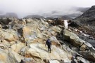
Slogging up the snow gully above Dome Ridge
Photograph
•
Distance: 1.3km away
It is a bit of a haul up this bit, especially if the snow is soft
More ▶︎
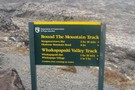
Soda Springs
Track
•
Easy. Return via same track.
•
Distance: 1.4km away
The easiest close approach to Ngauruhoe Volcano, following a smooth track through a raw, moonlike landscape to an oasis of ...
More ▶︎
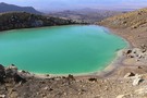
Emerald Lakes
Photograph
•
Distance: 1.4km away
Emerald lake viewed from the descent from Red Crater.
More ▶︎
New Track to Mangatepopo Saddle
GPX file
•
Distance: 1.5km away
Regular trampers into the Mangatepopo Valley may be interested in the route of the new, highly engineered track from the ...
More ▶︎
Winter conditions - Tongariro Crossing
Photograph
•
Distance: 1.5km away
c1300m on a very average August morning.
More ▶︎
Tongariro Northern Circuit
GPX file
•
Distance: 1.5km away
A complete log of the Tongariro Northern Circuit completed on March 8, 2008.
More ▶︎

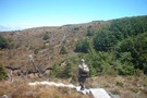
Into the wild
Photograph
•
Distance: 1.6km away
After the aptly named Devils staircase. A rewarding stretch in the clouds. Perhaps this could be renamed the stairway to ...
More ▶︎
Sunrise over Red Crater and the Blue Lake
Photograph
•
Distance: 1.6km away
From the top of Ngauruhoe, sunrise spreads it's light across the familiar but deserted landscape of tongariro.
More ▶︎

Tongariro Alpine Crossing
Track
•
1 day. Medium. One way.
•
Distance: 1.6km away
A popular but crowded alpine route through a spectacular volcanic landscape.
More ▶︎
Rim of Red Crater
Photograph
•
Distance: 1.6km away
Standing on the rim of Red Crater at the summit, Blue Lake in the background.
More ▶︎
Below Red Crater
Photograph
•
Distance: 1.6km away
View from the rim of South Crater, below Red Crater
More ▶︎
Ruapehu Te Hue Hue Summit
Track
•
Medium. Return via same track.
•
Distance: 1.7km away
Rocky walk in summer leaving from the Knoll Rigde Cafe' for a scramble
up the ridge. great views with very few ...
More ▶︎
Emerald Lakes, Tongariro crossing
Photograph
•
Distance: 1.7km away
Very rare image of the Lakes with no tourists in shot (I got lucky)
More ▶︎
Central Crater
Photograph
•
Distance: 1.7km away
Central Crater Mt Tongariro. This view is taken as we climb up to North Crater. Red Crater is to the ...
More ▶︎
North Crater
Photograph
•
Distance: 1.8km away
North Crater is a large plateau with great views to the north. There is a crater in the middle of ...
More ▶︎
Whangaehu Hut
Photograph
•
Distance: 1.9km away
Whangaehu Hut on Mt Ruapehu. Off the tourist circuit and a hidden gem. Like Rangipo it has views over the ...
More ▶︎

Whangaehu Glacier
Photograph
•
Distance: 1.9km away
Whangaehu Glacier - taken 5m from Whangaehu Hut door. The hut is perched atop a 200m bluff looking directly down ...
More ▶︎
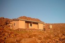
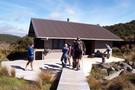
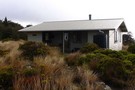
Whangaehu Hut
Hut
•
Basic Hut/Bivvy (NZAC). Capacity: 6.Bookings required.
•
Distance: 1.9km away
Built on the eastern slopes of Mt Ruapehu in the 1960's, with spectacular views across the Rangipo Desert and down ...
More ▶︎
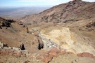
Rangipo Desert
Photograph
•
Distance: 1.9km away
The view from Whangaehu Hut taking in the Whangaehu River, the Rangipo Desert, the Desert Road (SH1) and the lands ...
More ▶︎
Rangipo Desert
Photograph
•
Distance: 1.9km away
Fantastic moon rise seen from the Hut after a day of up and down and up and down its a ...
More ▶︎
Whangaehu Hut
Photograph
•
Distance: 1.9km away
Located at 2060m, the highest altitude accommodation in the North Island. Fitted with DOC Lahar warning and earthquake detection system ...
More ▶︎
Emerald Lake - Winter
Photograph
•
Distance: 2.0km away
The lower Emerald Lake in its winter coat - taken June 2009. The track from Oturere Hut joins the Tongariro ...
More ▶︎
Mt.Ruapehu - Tukino side
Photograph
•
Distance: 2.0km away
Lostone (Dave) ascends to Mangatoetoenui glacier.
Almost at 2100m after parking at the locked gate(1400m) a few k's short of Tukino ...
More ▶︎
Ngauruhoe from Ruapehu
Photograph
•
Distance: 2.2km away
Two days of heavy snow gave way to a perfect day for a climb.
More ▶︎
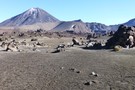
Ruapehu, Ngauruhoe, and Red Crater
Photograph
•
Distance: 2.2km away
These volcanoes and vents line up along the axis of the Taupo Volcanic Zone, a line of geothermal activity leading ...
More ▶︎
Blue Lake, Mount Tongariro
Photograph
•
Distance: 2.2km away
This lake occupies a crater next to the popular Tongariro Crossing track.
More ▶︎
Blue Lake Panorama
Photograph
•
Distance: 2.3km away
Mt Ngauruhoe, Red Crater, Mt Tongariro, my wife Helen, Blue Lake.
We're all walking on the moon.
More ▶︎
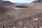
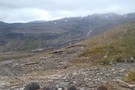
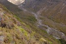
Oturere Valley
Photograph
•
Distance: 2.4km away
The Oturere Valley above Oturere Hut is a unique place. A real moonscape sculptured by lava flows
More ▶︎
delta corner Mt ruapehu
Photograph
•
Distance: 2.6km away
delta ridge location of NZ Alpine club hut
More ▶︎
Line up of Volcanos
Photograph
•
Distance: 2.7km away
This is one of the best places in Tongariro National Park to get a photo. All in a line, Blue ...
More ▶︎
Te Mari Craters
Track
•
Easy/medium. Return via same route.
•
Distance: 2.8km away
Unmarked walk to volcanic craters near Ketetahi Hut on the Tongariro Crossing
More ▶︎
Ketetahi Track
Track
•
0 – 2 days. Easy. Return via same track.
•
Distance: 2.8km away
Easy climb through forest and subalpine vegetation on the northern flank of the Tongariro Volcano
More ▶︎
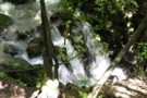
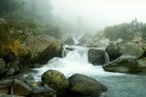
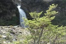
Small waterfall
Photograph
•
Distance: 2.8km away
A small waterfall below Ketetahi Springs, Tongariro.
More ▶︎
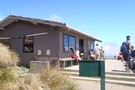
Ketetahi Hut
Photograph
•
Distance: 2.9km away
A modern great walk hut part of the Tongariro alpine crossing. A great place for and easy uncomplicated night out. ...
More ▶︎
Ketetahi Hut on a fine day
Photograph
•
Distance: 2.9km away
Looking North from Ketetahi hut towards Taupo
More ▶︎
Ketetahi Hut
Hut
•
Shelter (DOC).
•
Distance: 2.9km away
KITETAHI HUT HAS NOW BEEN COMPLETELY REMOVED.
the toilets are still there
This hut on the northern slopes of Mt Tongariro ...
More ▶︎

Great Walks Information
Article
•
Distance: 2.9km away
The DOC Great Walks are a set of premium tramping tracks throughout New Zealand.
More ▶︎
Sunset at Ketetahi Hut
Photograph
•
Distance: 2.9km away
Earth's shadow rises on the sky beyond Lake Taupō.
More ▶︎
Mangahouhounui Stream
Track
•
2 days. Medium. One way.
•
Distance: 2.9km away
An untracked alternative to getting from Ketetahi Hut to Oturere Hut and beats the madenning crowd.
More ▶︎
Ngauruhoe under a super moon
Photograph
•
Distance: 2.9km away
A long exposure (and painting the foreground with my head torch) led to a pleasing result.
More ▶︎
A beautiful morning at Mangatepopo
Photograph
•
Distance: 3.1km away
A cold start to a fantastic day up on the cones!
More ▶︎
Taking a stroll on Tongariro
Photograph
•
Distance: 3.1km away
Dave(lostone) is moving between Mangetepopo hut and Soda Springs whilst taking a walk up to South Crater. A chance to ...
More ▶︎
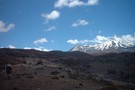
Lower Tama, Tama Saddle, and Ruapehu beyond
Photograph
•
Distance: 3.1km away
The Tama Lakes are old explosion craters remaining from past eruptions.
More ▶︎
Sulphur Lagoon
Photograph
•
Distance: 3.5km away
One of the Te Mari Craters on the northern flank of Tongariro, near Ketetahi Hut.
More ▶︎
The Majestic Mountain
Photograph
•
Distance: 3.6km away
Ruapehu as the sun was setting and cloud hanging around
More ▶︎
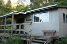
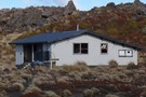
Mangatepopo Hut
Hut
•
Great Walks Hut (DOC). Capacity: 30.
•
Distance: 3.6km away
A Great Walk hut (must be booked in advance), easily accessible from the road-end. Gas heater and gas stove (in ...
More ▶︎
Tongariro Northern Circuit
Track
•
3 – 4 days. Easy/medium. Loop track.
•
Distance: 3.6km away
This circuit on the Volcanic Plateau passes close to the summit of Tongariro in a spectacular, active volcanic landscape of ...
More ▶︎
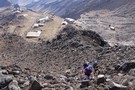
Climbing up from the Top of the Bruce
Photograph
•
Distance: 3.6km away
The first part of the climb up Mt Ruapehu involves climbing through the Whakapapa Ski Field
More ▶︎
Mangatepopo Hut
Photograph
•
Distance: 3.6km away
Too close to the road to be a useful hut really but very well appointed and a good stop for ...
More ▶︎
Having lunch at Upper Te Mari Crater May 2012
Photograph
•
Distance: 3.8km away
We had no inkling that the crater just above us would erupt in 3 months time.
More ▶︎
Te Mari Crater, post the August 2012 Eruption
Photograph
•
Distance: 3.8km away
Stll a fairly steamy scene
More ▶︎
Whanganui National Park
Place
•
National Park. 742.31km2.
•
Distance: 3.9km away
Lowland forest surrounding the long and sinuous Whanganui River, the longest navigable river in New Zealand. New Zealand's 11th national ...
More ▶︎
Lunarscape
Photograph
•
Distance: 3.9km away
It's a lunar like landscape that greets you after departing Oturere Hut for the Emerald Lakes.
Mount Ngarahoe offers a stunning ...
More ▶︎
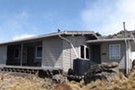
Oturere Hut
Photograph
•
Distance: 4.4km away
Northern tongariro circiut hut Gas burners and fire, Water and WC. Would be an intereting hut to visit mid winter
More ▶︎

Oturere Hut
Hut
•
Great Walks Hut (DOC). Capacity: 26.
•
Distance: 4.4km away
A grand location on the east side of Ngauruhoe in the Tongariro National Park. The smallish living area has 2 ...
More ▶︎
Routes from Oturere Bridge to Oturere Hut
GPX file
•
Distance: 4.4km away
Some years ago the prospect of a fast shortcut from Oturere Bridge to Oturere Hut has facinated me. I have ...
More ▶︎
Wangaehu River Swing Bridge - Round The Mountain (Ruapehu)
Photograph
•
Distance: 4.5km away
Site of the lahar that flowed down from the crater lake.
More ▶︎
Rotorua Tramping & Skiing Club
Club
•
Distance: 4.7km away
We are an active tramping club with trips most weekends. We also have a lodge on Mt Ruapehu and 2 ...
More ▶︎
Round The Mountain (Ruapehu) - Stage 3
GPX file
•
Distance: 4.7km away
This is an excellent day trip in good weather, or can be conveniently split into an overnight trip with a ...
More ▶︎
Maungaturuturu Valley
Photograph
•
Distance: 4.8km away
Steep cascade descending into Maungaturuturu Valley
More ▶︎
Lower Tama Lake
Photograph
•
Distance: 4.9km away
Worthwhile day trip from Whakapapa Village
More ▶︎
Lower Tama Lake
Photograph
•
Distance: 5.0km away
I took my Canadian cousins up to Tama Lake. They thoroughly enjoyed the trip
More ▶︎
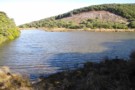
Lake Suprise, looking across the Mangaturuturu Valley
Photograph
•
Distance: 5.0km away
Lake Suprise is a populat day walk from the Ohakune Mountain Rd
More ▶︎
Round The Mountain (Ruapheu)
GPX file
•
Distance: 5.0km away
Stage 1 Round The Mountain Track
More ▶︎
High route to Blyth Hut
GPX file
•
Distance: 5.0km away
High route to Blyth Hut from the Turoa Road. This is a short cut on the Round the Mountain Track ...
More ▶︎
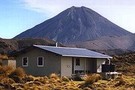
ATC Memorial hut, Ruapehu
Photograph
•
Distance: 5.1km away
ATC memorial hut, Iwikau village, Mt Ruapehu. taken August 2005.
More ▶︎
Rangipo Hut - Round The Mountain (Ruapehu)
Photograph
•
Distance: 5.4km away
The hut at dawn. A magic place to be on a still, clear morning.
More ▶︎
Round the Mountain: Ruapehu
Track
•
5 days. Easy/medium. Loop track.
•
Distance: 5.4km away
Combined with part of the Tongariro Northern Circuit, this track forms a loop around Mt Ruapehu. Combined with the other ...
More ▶︎
Rangipo Hut
Hut
•
Standard Hut (DOC).
•
Distance: 5.4km away
A welcome spot going either way around the Ruapehu Circut, this hut is located at about the only shelted spot ...
More ▶︎
Rangipo Hut
Photograph
•
Distance: 5.4km away
20-bunk hut on the lower, eastern slopes of Mt Ruapehu. Sometimes a warden is in residence during the summer.
More ▶︎
Rangipo Hut -
Photograph
•
Distance: 5.4km away
After our mid winter xmas dinner.
Leaving the hut to go back to our cars at the 2w Drive car park ...
More ▶︎
Rangipo Hut in winter
Photograph
•
Distance: 5.4km away
Rangipo hut on Mt Ruapehu a couple of days after a big snow storm. A shovel was needed to dig ...
More ▶︎
Round The Mountain (Ruapehu) - Stage 2
GPX file
•
Distance: 5.4km away
This is a pleasant two-day walk around the eastern part of the Round The Mountain (Ruapehu) Track. The walk begins ...
More ▶︎
Tama Lakes Track
Track
•
Medium. Return via same track.
•
Distance: 5.5km away
A good day walk onto the Tama Saddle, visiting explosion craters near the foot of Ngauruhoe. Excellent panoramic views on ...
More ▶︎
Mt Ngauruhoe - Tongariro Circuit
Photograph
•
Distance: 5.5km away
3 JUN 2011 - on the Tongariro circuit between Waihohonu and Oturere Huts. Approx 20min walk north of Waihohonu.
More ▶︎
Ohakune Mountain Road
Photograph
•
Distance: 5.5km away
Entry Point for Round the Mountain toward Whakapapa
More ▶︎

Whakapapaiti Valley Loop (Tongariro National Park)
GPX file
•
Distance: 5.6km away
This is a delightful six hour day trip from the Whakapapa Village Visitors Centre. Take your lunch and enjoy the ...
More ▶︎
Whakapapiti Valley Loop (Tongaririo National Park)
GPX file
•
Distance: 5.6km away
This is a delightful easy six hour day trip from the Whakapapa Village Visitors Centre. Take your lunch and enjoy ...
More ▶︎
Traversing around Mt Tongariro
Photograph
•
Distance: 5.6km away
Heading towards Oturere hut from the Mangahouhounui Valley. Mt Ruapehu beyond
More ▶︎
Bruce Road
Photograph
•
Distance: 5.8km away
Exit point for Round the Mountain track on Bruce Road above Whakapapa village.
More ▶︎
Mangahouhounui Stream
Photograph
•
Distance: 5.8km away
Looking down into the Mangahouhounui Stream
More ▶︎
Mangahouhounui Stream
Photograph
•
Distance: 5.9km away
The Mangahouhounui Stream down where it entes the bush on a foggy morning
More ▶︎
Te Tatau Pounamu Wilderness Area
Place
•
Wilderness Area. 64.75km2.
•
Distance: 5.9km away
Forested northeastern slopes of the Tongariro volcano complex within Tongariro National Park.
More ▶︎
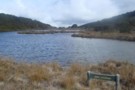
Lake Suprise
Photograph
•
Distance: 5.9km away
Lake Suprise close up. When calm it has nice reflections
More ▶︎
Lake Surprise
Track
•
1 day. Medium. Return via same track.
•
Distance: 5.9km away
Walk to Lake Suprise, Mountain Track
More ▶︎
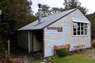
Mangaturuturu Hut
Photograph
•
Distance: 6.0km away
This hut has a long history associated with the Wanganui Tramping Club. It is now administered by DOC and is ...
More ▶︎
Mangaturuturu Hut
Hut
•
Standard Hut (DOC). Capacity: 8.
•
Distance: 6.0km away
Hut on the walk from Turoa Road to Lake Surprise, about 1.5 hours in.
More ▶︎
Blyth Hut, via waitonga falls
Track
•
1 – 2 days. Easy/medium. Return by the same track.
•
Distance: 6.1km away
Bush, river and tops adventure on the flanks of ruapehu in Tongariro NP. Perfect for the Whole family.
More ▶︎
Whakapapaiti
Hut
•
Serviced Hut (DOC). Capacity: 18.
•
Distance: 6.2km away
18 Bunk hut 2.5hrs from Whakapapa Village
More ▶︎
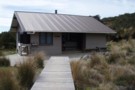
Whakapapaiti Hut
Photograph
•
Distance: 6.2km away
18 Bunk hut part of the ruapehu round the mountain track
More ▶︎
Mountain Tarn
Photograph
•
Distance: 6.3km away
Looking towards Hauhungatahi volcano which is thought to have erupted about 900,000 years ago, and therefore is significantly older than ...
More ▶︎
Old Waihohonu Hut
Photograph
•
Distance: 6.4km away
This historic hut is well worth the side trip on the Round The Mountain Track (Stage 1) (Ruapehu)
More ▶︎
Historic Waihohonu Hut
Hut
•
Standard Hut (DOC).
•
Distance: 6.5km away
This original Waihohonu hut was constructed in 1904 and is now a historic building with no accommodation. You can stay ...
More ▶︎
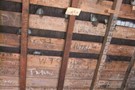
Old Waihohonu Hut graffiti
Photograph
•
Distance: 6.5km away
The youth of today!!!......graffiti on the rafters go back to at least 1918. If you are in the hut take ...
More ▶︎
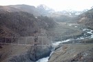
Waihohonu Bridge - Round The Mountain (Ruapehu)
Photograph
•
Distance: 6.7km away
Bridge near Waihohonu Hut - ideal area for lunch
More ▶︎
Waihohonu Hut
Hut
•
Great Walks Hut (DOC). Capacity: 28.
•
Distance: 6.8km away
The best hut on the Tongariro Northern Crossing. New flush! toilets. Three sleeping areas: one cosy room next to the ...
More ▶︎

Waihohonu Hut
Photograph
•
Distance: 6.8km away
A typical lockwood Tongariro National Park Hut. It was supposed to be replaced but they have just built a new ...
More ▶︎
Waihohonu Hut
Photograph
•
Distance: 6.8km away
This is a new DOC hut on the Tongariro Northern Circuit completed late DEC 2010. It is about a 5min ...
More ▶︎
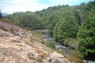
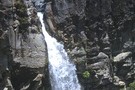
Mangaturuturu falls
Photograph
•
Distance: 6.8km away
Mangaturuturu waterfall, about 1km downstream from Mangaturuturu hut.
taken Feb 2006.
More ▶︎
Blyth Hut
Hut
•
Standard Hut (DOC). Capacity: 20.
•
Distance: 6.9km away
This hut is slightly off the Around Mt Ruapehu Track on a dead end track so is often bi passed.
More ▶︎
Blyth Hut
Photograph
•
Distance: 6.9km away
The front of this well appointed hut with its wide roomy deck
More ▶︎
Lupton Hut
Photograph
•
Distance: 7.1km away
Lupton Hut sits in a pleasant flat beside the stream, 10 mins below Blyth Hut
More ▶︎
Lupton Hut
Hut
•
Private hut (Wanganui High School). Capacity: 8.
•
Distance: 7.1km away
Only 10 minutes away from Blyth Hut, this is a private hut, owned by the Wanganui High School, but is ...
More ▶︎
Mangaehuehu Hut - Round The Mountain (Ruapehu)
Photograph
•
Distance: 7.3km away
Excellent hut with a wonderful view.
More ▶︎
Mangaehuehu hut
Photograph
•
Distance: 7.3km away
Great views from this hut over Waiouru and back up to Ohakune. Conversely, it can be very windy too
More ▶︎
Mangaehuehu Hut
Hut
•
Standard Hut (DOC).
•
Distance: 7.3km away
On the around Mt Ruapehu Track this hut provides a welcome stop after the long day through the Rangipo desert ...
More ▶︎
Swing Bridge - Round The Mountain (Ruapehu)
Photograph
•
Distance: 7.4km away
About 30 mins past Mangaehuehu Hut toward Ohakune Mountain Road there is a wonderful landscape of mixed bush and subalpine ...
More ▶︎
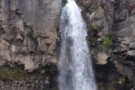
Taranaki Falls
Photograph
•
Distance: 7.5km away
These picturesque falls are located within easy walking distance of the Chateau Tongariro and are well worth visiting.
A harmless challenge ...
More ▶︎
Mangatoetoenui Stream - Round The Mountain (Ruapehu)
Photograph
•
Distance: 7.5km away
Upper reaches of the stream which is crossed by the track. Typical "desert" like landscape. View of Mt Ruapehu in ...
More ▶︎
Silica Rapids Walk
Track
•
Easy. Loop track with a road section.
•
Distance: 7.8km away
Creamy-white aluminosilicate deposits near Whakapapa village.
More ▶︎
Rotokawa Tarn - Round The Mountain Track (Ruapehu)
Photograph
•
Distance: 8.0km away
Excellent viewpoint not far from Ohakune Mountain Road.
More ▶︎
Ohakune Mountain Road
Photograph
•
Distance: 8.1km away
Entry Point for Round The Mountain Track
More ▶︎
Ridge Track
Track
•
Easy. Return via same track.
•
Distance: 8.5km away
A brief climb onto the subalpine shrub fields offering panoramic views.
More ▶︎
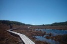
Ruapehu round the mountain track
Photograph
•
Distance: 8.7km away
Board walk on the Ruapehu round the mountain track west of Whakapapa village.
More ▶︎
Whakapapa Nature Walk
Track
•
Easy. Loop track.
•
Distance: 8.7km away
A brief sealed track introducing the park's vegetation zonation.
More ▶︎
Whakapapa Village
Place
•
Place.
•
Distance: 9.1km away
A small village located inside Tongariro National Park, a World Heritage Area.
More ▶︎
Whakapapaiti Valley
Track
•
1 day. Easy. Loop track with a road section.
•
Distance: 9.2km away
This is an easy day trip in summer from Whakapapaiti Village. Allow about six hours, but you can do it ...
More ▶︎
Whakapapanui Track
Track
•
Easy. Return via road or same track.
•
Distance: 9.8km away
An easy all-weather walk through forest alongside the Whakapapanui Stream.
More ▶︎