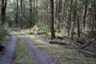
Nearby
Lake Daniels to Lake Rotoroa
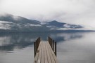
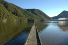
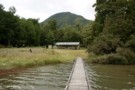
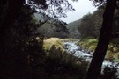
D'Urville Jetty
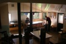
Photograph
•
Distance: 262m away
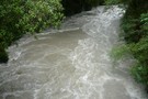
... at the hut. Zoom in and you'll see the sandflies ...
More ▶︎
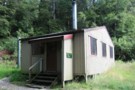
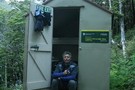
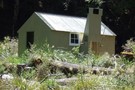
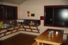
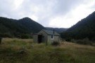
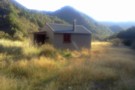
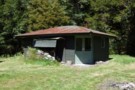
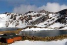
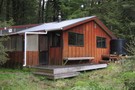
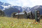
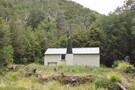
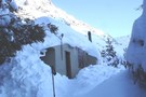
D'Urville Hut
Hut
•
Standard Hut (DOC). Capacity: 10.
•
Distance: 502m away
Located at the head of Lake Rotoroa.
More ▶︎
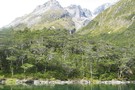
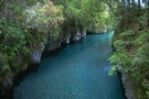
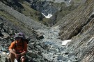
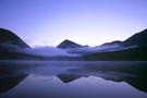
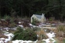
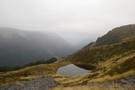
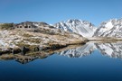
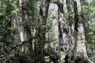
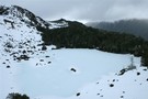
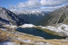
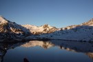
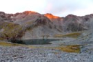
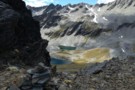
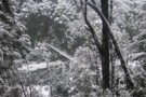
Blue Lake Jan 2007
Photograph
•
Distance: 502m away
This was a 'rite-of-passage' tramp for my 13 year old son. We helicoptered in to the Waiau Pass and then ...
More ▶︎
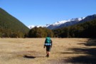
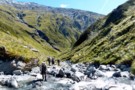
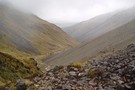
Sabine Valley - Blue Lake - D'Urville Valley
Track
•
4 – 5 days. Medium. Circuit.
•
Distance: 502m away
A circuit along neighbouring valleys at the hear of Lake Rotoroa, passing the picturesque Blue Lake, and crossing Moss Pass. ...
More ▶︎
Sabine-Waiau Pass-Thompson Pass-D'Urville
Track
•
5 – 7 days. Easy/medium. Loop track.
•
Distance: 1.1km away
5 day trip accessed by kayak up Lake Rotoroa. Easy bush travel up and down Sabine and D'Urville valleys respectively. ...
More ▶︎
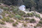
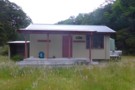
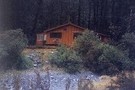
Mole Hut
Hut
•
Basic Hut/Bivvy (DOC). Capacity: 4.
•
Distance: 1.4km away
A brilliant hut to visit close to Murchison within the Tutaki Conservation Area, on the edge of Nelson Lakes National ...
More ▶︎
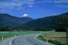
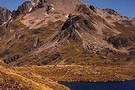
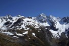
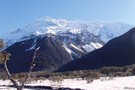
Mount Haast
Photograph
•
Distance: 2.1km away
A striking profile from the road into Springs Junction.
More ▶︎
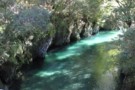
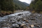
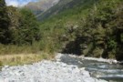
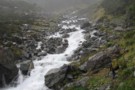
Sluice Box
Track
•
Easy. Return by the same track.
•
Distance: 2.2km away
A narrow slot cut into marble by the Maruia River on the Lake Daniell Track
More ▶︎
The Sluice Box
Photograph
•
Distance: 2.2km away
A short walk from Marble Hill Camping Area.
More ▶︎
Lewis Pass National Reserve
Place
•
Reserve. 182.95km2.
•
Distance: 2.2km away
A small park occupying the forested valleys around Lewis Pass and bordering Lake Sumner and Victoria Forest Parks as well ...
More ▶︎
Pell Stream
Track
•
2 – 3 days. Medium. Loop track with a road section.
•
Distance: 2.3km away
This highly recommended valley not far from the highway west of the Lewis pass, is accessible to most people with ...
More ▶︎
Nelson Lakes double figure eight with a reverse twist
Article
•
Distance: 3.0km away
January 2008.
A seven day epic up and over Lake Angelus from Speargrass Hut, then up the Sabine River, over Waiau ...
More ▶︎
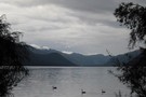
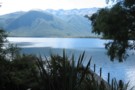
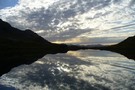
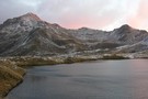
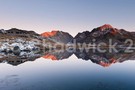
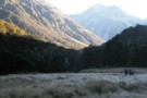
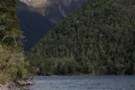
Lake Rotoroa
Photograph
•
Distance: 3.0km away
from the verandah of Sabine Hut - no wonder this hut is popular - Apr 2011
More ▶︎
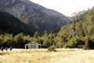
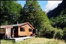
Sabine Hut
Photograph
•
Distance: 3.0km away
picturesque setting at the head of Lake Rotoroa but prone to crowding at holiday times (and not just by sandflies) ...
More ▶︎
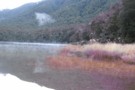
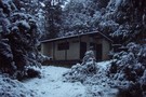
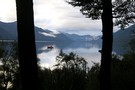
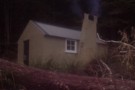
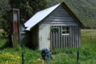
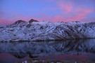
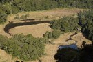
Morning @ Lake Daniells
Photograph
•
Distance: 3.0km away
Morning @ Lake Daniells from jetty
More ▶︎
Morning @ Lake Daniells
Photograph
•
Distance: 3.0km away
Morning @ Lake Daniells view from the hut
More ▶︎
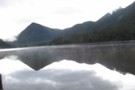
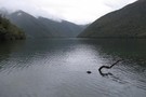
Lake Daniells
Photograph
•
Distance: 3.0km away
10-15 minutes walk from the start of the track.
More ▶︎
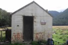
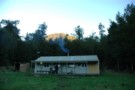
Thompsons Flat Hut
Photograph
•
Distance: 3.0km away
A great hut to escape to, an hour or so beyond Lake Daniells and away from the crowds, sleeps 4 ...
More ▶︎
Lake Daniells from hut
Photograph
•
Distance: 3.0km away
Lake Daniells and jetty from Manson-Nicholls Memorial Hut. Photo taken by Andrea
More ▶︎
Lake Daniells
Track
•
1 – 2 days. Easy. Return via same track.
•
Distance: 3.0km away
Lake Daniells is a tranquil, shallow lake west of Lewis Pass. The walk in is along easy, well-maintained tracks through ...
More ▶︎
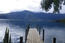
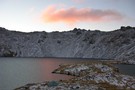
Jetty at Sabine Hut
Photograph
•
Distance: 3.0km away
Early morning - April 2010 - I think it's going to rain...
More ▶︎
Travers-Sabine Saddle
Photograph
•
Distance: 3.0km away
Going over the saddle looking west towards the Sabine Valley - April 2010.
More ▶︎
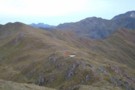
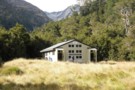
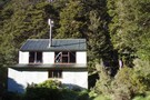
Sabine Hut
Hut
•
Serviced Hut (DOC). Capacity: 32.
•
Distance: 3.0km away
Located at the head of Lake Rotoroa. A radio is available for contacting the water taxi service.
More ▶︎
Travers-Sabine
Track
•
4 – 7 days. Medium. Loop track with a road section.
•
Distance: 3.0km away
Two river valleys linked by a straightforward alpine saddle at 1800m
More ▶︎
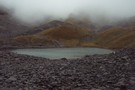
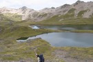
Blue Lake
Track
•
2 – 4 days. Easy/medium. Return via same track.
•
Distance: 3.0km away
Blue Lake is a small, pretty lake dammed by boulders at the head of the Sabine Valley. Beyond is Lake ...
More ▶︎
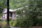
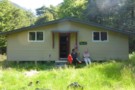
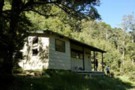
Manson-Nicholls Memorial Hut
Photograph
•
Distance: 3.3km away
Manson-Nicholls Memorial Hut at Lake Daniells - tidy hut with 20 bunks.
Photo by Andrea
More ▶︎
Manson Nicholls Memorial Hut
Hut
•
Serviced Hut (DOC). Capacity: 20.
•
Distance: 3.3km away
This hut is very popular with beginning trampers, families, and school groups. The hut is a decent size with ample ...
More ▶︎
Manson-Nicholls Memorial Hut
Photograph
•
Distance: 3.3km away
Lakeside hut with tranquil views and only interrupted by other trampers - this place is popular.
More ▶︎
Freyberg Range, Pell Stream
Article
•
Distance: 3.5km away
A 3 day trip, climbing up onto the range to go over Mt Mueller and camp. Followed by a descent ...
More ▶︎
Thompson's Flat Hut
Photograph
•
Distance: 3.5km away
Thompson's Flat Hut, north of Lake Daniells. A 4 bunk forestry hut.
More ▶︎
Mount Misery Hut
Hut
•
Basic Hut/Bivvy (DOC). Capacity: 4.
•
Distance: 3.5km away
Mount Misery hut
More ▶︎
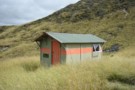
Pell Stream Hut
Hut
•
Basic Hut/Bivvy (DOC). Capacity: 4.
•
Distance: 3.6km away
Small hut at the end of the Pell Stream Track.
More ▶︎
Pell Stream hut August 2011
Photograph
•
Distance: 3.6km away
Neil B & I recently visited this hut. There have been some track improvements since I was last there. Hut ...
More ▶︎
Pell Stream hut Dec 2008
Photograph
•
Distance: 3.6km away
We visited this hut as a day trip from the Marble Hill camping area.
It seemed a good comfortable hut with ...
More ▶︎
Thompson's Flat Hut
Hut
•
Basic Hut/Bivvy (PVT). Capacity: 4.
•
Distance: 3.7km away
An old hunters hut near Lake Daniell. This is a private hut on private land.
More ▶︎
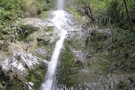
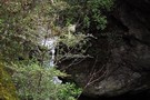
waterfall
Photograph
•
Distance: 3.7km away
nice walk but some of the track missing at the moment due to slip
More ▶︎
Five Mile Creek Falls
Track
•
Easy. Return via same track.
•
Distance: 3.7km away
Short track to precipitous 40m falls
More ▶︎
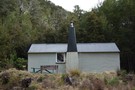
Morgan Hut
Photograph
•
Distance: 3.8km away
The new hut, about 1km further up from the old site.
More ▶︎
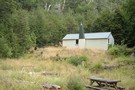
Morgan Hut
Hut
•
Standard Hut (DOC). Capacity: 10.
•
Distance: 3.8km away
Located on the D'Urville River south of Lake Rotoroa.
More ▶︎
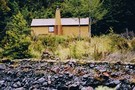
Morgan Hut
Photograph
•
Distance: 3.8km away
Morgan Hut on the D'Urville River. 10 bunks and lots of sandflies.
More ▶︎
Upper Glenroy Hut [Removed]
Hut
•
Removed!
•
Distance: 3.9km away
Hut located on the upper Glenroy River. Removed about 2005.
More ▶︎
Pell Stream
Photograph
•
Distance: 3.9km away
open travel just above the second gorge section (going up)
More ▶︎
Nardoo Hut
Hut
•
Basic Hut/Bivvy (DOC). Capacity: 2.
•
Distance: 4.1km away
Hut above the bushline on the tops between the Glenroy and Matakitaki Rivers.
More ▶︎
Over the Sabine River
Photograph
•
Distance: 4.1km away
First bridge after Sabine Hut, I think
More ▶︎
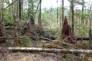
D'Urville windfall
Photograph
•
Distance: 4.7km away
This is a little bit of the windfall on the D'Urville track between D'Urville Hut and Morgan Hut. It may ...
More ▶︎
Mataki Lodge
Hut
•
Private hut (PVT). Capacity: 32.Bookings required.
•
Distance: 5.2km away
Nelson College Mataki Lodge
More ▶︎
Tiraumea Hut
Photograph
•
Distance: 5.4km away
Standard 6 Bunk DOC hut by Tiraumea River - located in a large clearing about 1.5 hrs from Tiraumea Saddle, ...
More ▶︎
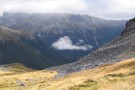
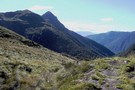
Tarns on range south of Mt Misery
Photograph
•
Distance: 5.9km away
Tarns below pt1609, rapidly losing their emerald colour as mist sets in..
Nearly at the end of a long climb ...
More ▶︎
Burn Creek Hut
Hut
•
Basic Hut/Bivvy (DOC). Capacity: 2.
•
Distance: 6.0km away
The little hut with a steep-pitched roof is located just under the Emily Peaks next to some beech forest. Given ...
More ▶︎
Burn Ck Bivvy
Photograph
•
Distance: 6.0km away
A basic 2 bunk bivvy that has seen better days.
Burn ck is fairly tight and gorgey with plenty of sidling ...
More ▶︎
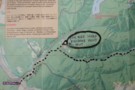
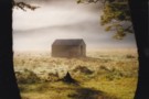
Location map in Blackadder's hut
Photograph
•
Distance: 6.1km away
I snapped this pic of the map on the wall of Blackadder's hut.
I note that the location has been described ...
More ▶︎
Blackadder's hut
Photograph
•
Distance: 6.1km away
This hut is located on Frazers Flat on the TR of Pell Stream about 400m above the confluence with the ...
More ▶︎
Blackadder's hut
Hut
•
Private hut (Blackadder Family Trust). Capacity: 10.
•
Distance: 6.1km away
This hut is located on Frazers Flat on the TR of Pell Stream about 400m above the confluence with the ...
More ▶︎
Downie Hut
Hut
•
Basic Hut/Bivvy (DOC). Capacity: 4.
•
Distance: 6.3km away
Downie Hut is an old board and batten hut with a large open fire place. The original shingle roof now ...
More ▶︎
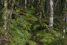
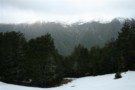
Nelson Lakes National Park
Place
•
National Park. 1017.53km2.
•
Distance: 6.3km away
An alpine park of beech forests, valleys, and glacial lakes, offering some relatively easy walking. Established in 1956. Highest point: ...
More ▶︎
Rough Creek Track
Track
•
Medium. Return via same track.
•
Distance: 6.5km away
The track leads up to Rough Creek Saddle from where there is a great view on Lake Christabel and the ...
More ▶︎
Rough Creek track
Photograph
•
Distance: 6.5km away
Rough Creek track on one of the steeper parts
More ▶︎
Rough Creek tops, view east
Photograph
•
Distance: 6.5km away
View down Rough Creek from slightly north of the track
More ▶︎
Rough Creek Tops
Photograph
•
Distance: 6.5km away
2010 in the hanging basin at the head of Rough Creek
More ▶︎
George Lyon Hut
Hut
•
Standard Hut (DOC). Capacity: 16.
•
Distance: 6.5km away
Formerly Ella Hut, located on the D'Urville River.
More ▶︎
Downies Hut
Hut
•
Basic Hut/Bivvy (DOC). Capacity: 4.
•
Distance: 6.6km away
Historic hut on the Matakitaki River, dating back to 1902 or earlier. The hut is perhaps the second oldest in ...
More ▶︎
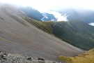
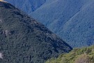
Scree beside the Cedric Track
Photograph
•
Distance: 6.7km away
looking up the Sabine Valley from the Cedric Track - Feb 2013
More ▶︎
George Lyon Hut
Photograph
•
Distance: 6.8km away
George Lyon Hut on the D'Urville River is a 16 bunk DoC hut. The hut is divided into 2 rooms ...
More ▶︎

St Arnaud - Lewis Pass
Article
•
Distance: 7.5km away
A 9-day 100km tramp via the Thompson, D'Urville and 3 Tarns Passes
Feb 2013
More ▶︎

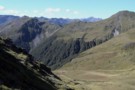
Profile : St Arnaud - Lewis Pass
Photograph
•
Distance: 7.5km away
A useful profile of the 100km tramp - with a couple of bad weather alternatives :
1. low route past Speargrass ...
More ▶︎
West Matakitaki Valley
Photograph
•
Distance: 7.7km away
traveling up the valley to 3 Tarns, it's easiest to keep to the river until the last push to the ...
More ▶︎
Nelson Lakes - Angelus to Sunset Saddle
GPX file
•
Distance: 7.7km away
Route marked by cairns from Angelus Hut to Sunset Saddle. (The first part of the route to Hopeless Creek and ...
More ▶︎
Lewis Tops from Mueller Tarn
Photograph
•
Distance: 7.9km away
This is the view south across the valley.
More ▶︎
Mueller Tarn
Photograph
•
Distance: 7.9km away
A snowy tarn just above the treeline near Maruia Springs.
More ▶︎
Mueller Tarn Track
Track
•
Easy/medium. Return via same track.
•
Distance: 8.1km away
A steep but easy climb to a pretty alpine tarn near Lewis Pass
More ▶︎
W Matakitaki - Ada Pass Hut
GPX file
•
Distance: 8.1km away
Treeline in West Matakitaki Valley to Ada Pass Hut, via 3 Tarns Pass
An actual, recorded, gpx – the only thing ...
More ▶︎
Hinapouri Tarn
Photograph
•
Distance: 8.3km away
looking across the tarn into the Hukere Stream/Valley (through which the Cascade track runs)
More ▶︎
Camp above Rough Creek
Photograph
•
Distance: 8.5km away
Superb camp site by a small tarn only 100m from the Rough Creek saddle on the way to Lake Christabel
More ▶︎
Lake of the Angels
Photograph
•
Distance: 8.6km away
We arrived at Lake Angelus as a thick fog descended and the temperature dropped to zero. Next morning we were ...
More ▶︎
Lake Angelus
Track
•
2 – 3 days. Medium. loop track.
•
Distance: 8.6km away
Between the lakes of Rotoiti and Rotoroa in New Zealand's South Island, is the high alpine tarn of Lake Angelus ...
More ▶︎
Route Guide: Lake Angelus
Article
•
Distance: 8.6km away
Between the lakes of Rotoiti and Rotoroa in New Zealand's South Island, is the high alpine tarn of Lake Angelus ...
More ▶︎
Lake Angelus with no snow
Photograph
•
Distance: 8.6km away
Unusually snow free - January 2008
More ▶︎
Sunset over Lake Angelus
Photograph
•
Distance: 8.7km away
An awesome day and evening, taken May 2011.
More ▶︎
Angelus Peak
Photograph
•
Distance: 8.7km away
evening light on the Angelus Peak (2075m), looking across the lake - Sunset Saddle is in the middle of the ...
More ▶︎
Lake Angelus at Sunset
Photograph
•
Distance: 8.7km away
looking towards Bristol Pass, some hardy campers in front of the Angelus Hut - Apr 2011
More ▶︎
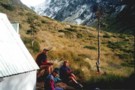
South side of 3 Tarns Pass
Photograph
•
Distance: 8.8km away
campsite and tarn as sunset approaches
Feb 2013
More ▶︎
Klondyke Spur
Track
•
1 day. Medium. Return by the same track.
•
Distance: 8.8km away
A route from Rahu Saddle onto the unnamed peaks of the Victoria Range.
More ▶︎
Klondyke Valley
Track
•
1 day. Easy/medium. Return by the same track.
•
Distance: 8.8km away
Valley track to tarns near the bushline.
More ▶︎

Tiraumea
Photograph
•
Distance: 8.8km away
Tiraumea River - flats at last, 5km below the hut.
More ▶︎
Angelus Hut
Hut
•
Serviced Hut (DOC). Capacity: 28.Bookings required.
•
Distance: 8.9km away
New hut opened in April 2010. A well sited and busy hut next to a lake in an alpine landscape. ...
More ▶︎
Angelus Hut Campsite
Campsite
•
Backcountry Campsite (DOC). 5 spaces.
•
Distance: 8.9km away
Alpine campsite located near Angelus Hut and Lake Angelus. During peak season, this campsite must be booked in advance with ...
More ▶︎
Lake Angelus, June 2011
Photograph
•
Distance: 8.9km away
Late in the day as we arrived at the hut with the last light catching the tops
More ▶︎
Nelson Lakes - Lakehead, Angelus and Speargrass Circuit
GPX file
•
Distance: 9.0km away
From St Arnaud along Lake Rotoiti to Lakehead Hut, then crossing the Travers River and via the Cascade Track to ...
More ▶︎
3 Tarns Pass
Photograph
•
Distance: 9.0km away
from the Pass, looking back to the 3 tarns
the better camping is on the south side of the pass
Feb 2013
More ▶︎
Mt Hopeless 2278m Nov 2012
Photograph
•
Distance: 9.0km away
This picture of Mt Hopeless 2278m was taken on a perfect morning from a knob above the Cupola Basin hut. ...
More ▶︎
Three Tarns, Three Tarns Pass
Photograph
•
Distance: 9.0km away
Three Tarns, Three Tarns Pass - at the head of the West Matakitaki Valley
More ▶︎
Robinson Saddle
Track
•
3 days. Easy/medium. One way.
•
Distance: 9.1km away
Forest and tops walk in Victoria Forest Park, visiting Lake Christabel.
More ▶︎
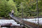
West Sabine Bridge
Photograph
•
Distance: 9.2km away
Feb 2013 - Just upstream from the hut, the new bridge was a pleasant surprise as the DOC website didn't ...
More ▶︎
previous West Sabine bridge
Photograph
•
Distance: 9.2km away
washed away in 2012 and replaced with one just upstream of West Sabine hut
More ▶︎
West Sabine Hut
Photograph
•
Distance: 9.3km away
April 2010 - small wood burner inside....but sufficient
More ▶︎
West Sabine Hut
Hut
•
Serviced Hut (DOC). Capacity: 34.
•
Distance: 9.3km away
Located in the West Branch of the Sabine River, south of Lake Rotoroa.
More ▶︎

Route Guide: St Arnaud to Lewis Pass
Article
•
Distance: 9.3km away
A 5-7 day north-south route from St Arnaud to the Lewis Pass, via Travers Pass, Waiau Pass, Thompson Pass and ...
More ▶︎

Lake Thompson
Photograph
•
Distance: 9.3km away
A view of the beautiful Lake Thompson, a short distance from Thompson Pass
More ▶︎
West Sabine River
Photograph
•
Distance: 9.3km away
West Sabine River, below West Sabine Hut, Nelson lakes
More ▶︎
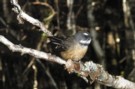
Fantail
Photograph
•
Distance: 9.3km away
Fantail near Cannibal Gorge Hut on the Saint James Walkway
More ▶︎
Frosty Morning Maruia River
Photograph
•
Distance: 9.3km away
Trampers on a frosty morning in the upper Maruia River near Cannibal Gorge.
More ▶︎
Cannibal Gorge Hut
Photograph
•
Distance: 9.3km away
Cannibal Gorge Hut is the first hut on the St James walkway from the Lewis Pass end
More ▶︎
Cannibal Gorge Hut
Photograph
•
Distance: 9.3km away
Cannibal Gorge Hut is the first hut on the St James walkway from the Lewis Pass end. Sleeps 20. Nice ...
More ▶︎

Cannibal Gorge, Ada Pass
Track
•
2 days. Easy. Return via same track.
•
Distance: 9.4km away
An easy overnighter through the pretty bush of Cannibal Gorge and on to the alpine views of Ada Pass.
More ▶︎
Cannibal Gorge Hut
Hut
•
Serviced Hut (DOC). Capacity: 20.
•
Distance: 9.4km away
The first hut on the western end of the St James Walkway.
More ▶︎
View towards Speargrass Creek
Photograph
•
Distance: 9.5km away
View from a couple of hundred meters below the rim of the Angelus basin, looking down a valley leading to ...
More ▶︎
Hopeless Creek Hut
Hut
•
Standard Hut (DOC). Capacity: 6.
•
Distance: 9.6km away
An older , little used hut off the Travers Valley leading to Sunset Saddle and Angelus Hut.
More ▶︎
Hopeless Hut
Photograph
•
Distance: 9.6km away
A six bunk hut situated near Hopeless Creek, which is a tributary of the Travers River. The lower story is ...
More ▶︎
West Matakitaki valley
Photograph
•
Distance: 9.6km away
West Matakitaki valley, heading from Bob's Hut to Three Tarn Pass
More ▶︎
Head of Lake Christabel August 2010
Photograph
•
Distance: 9.6km away
Lake Christabel is a large boomerang shaped lake approx 3km long. The lake was caused centuries ago by a slip ...
More ▶︎
Lake Christabel hut August 2010
Photograph
•
Distance: 9.6km away
A tidy hut situated on the TL bank of the Blue Grey River about 20 minutes above Lake Christabel near ...
More ▶︎
Lake Christabel Hut
Hut
•
Standard Hut (DOC). Capacity: 8.
•
Distance: 9.6km away
A tidy hut situated on the TL bank of the Blue Grey River about 20 minutes above Lake Christabel near ...
More ▶︎
St Arnaud to Lewis Pass
Track
•
5 – 9 days. Medium/hard. One way.
•
Distance: 9.6km away
A 5-9 day north-south route from St Arnaud to the Lewis Pass, via Travers Pass, Waiau Pass, Thompson Pass and ...
More ▶︎
Picton to Aspiring
GPX file
•
Distance: 9.8km away
An aborted alpine traverse. Picton to West Cape, but aborted at Aspiring due to real world emergencies back home. Posted ...
More ▶︎
The hills are alive
Photograph
•
Distance: 9.9km away
Walking from West Sabine Hut to Blue Lake, the heavens opened and the mountainside just came alive, sprouting waterfalls all ...
More ▶︎
Waiau - Clarence Pass Lake Tennyson Circuit
Track
•
4 – 5 days. Medium/hard. Loop track.
•
Distance: 9.9km away
A challenging 4-5 day circuit in the St. James Conservation Area / Nelson Lakes National Park featuring two alpine pass ...
More ▶︎
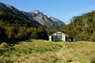
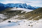
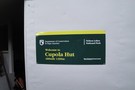
Cupola basin Hut
Photograph
•
Distance: 10.0km away
A snow covered Cupola Basin Hut visited on 6th and 7th July 2008.Stunning views of the surrounding mountains make the ...
More ▶︎
Cupola basin Hut
Hut
•
Standard Hut (DOC). Capacity: 8.
•
Distance: 10.0km away
A hut on the bushline with great views, well worth the up-hill grunt to get there.Even more spectacular when visited ...
More ▶︎
Cupola Basin Hut
Photograph
•
Distance: 10.0km away
Walked in from St. Arnaud and stayed overnight April 2002, as part of the popular Travers/Sabine circuit. I must have ...
More ▶︎
Ada Pass Hut
Hut
•
Serviced Hut (DOC). Capacity: 20.
•
Distance: 10.0km away
Ada Pass Hut (sleeps 14 on platform beds, matresses, stove, tank & river water) is a large, comfortable two-room hut ...
More ▶︎
Ada Pass Hut
Photograph
•
Distance: 10.0km away
Ada Pass Hut after a seasonal March snowfall.
More ▶︎
Ada Pass Hut
Photograph
•
Distance: 10.0km away
20-bunker nested into the bush edge with excellent sub-apline vista from the balcony.
More ▶︎