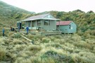
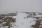
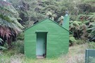
Nearby
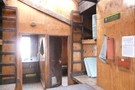
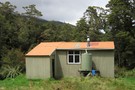
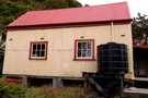
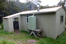
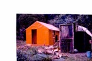
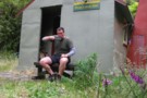
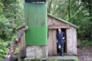
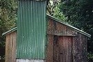
Elder Hut
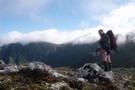
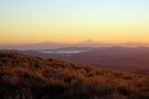
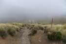
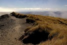
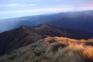
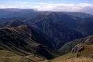
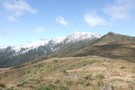
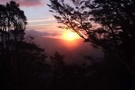
Southern Crossing Tararuas
Photograph
•
Distance: 2.4km away
Leaving Aston the ruas didnt disappoint fine in the morning high winds and clag around lunch and fine by the ...
More ▶︎
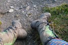
Working Boots
Photograph
•
Distance: 3.9km away
My boots and rainbow leggings - 2 days into Southern Crossing of Tararua Range
More ▶︎
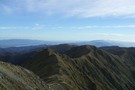
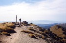
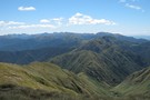
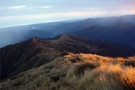
Mt. Hector
Photograph
•
Distance: 4.4km away
Looking across the Tararua main range from Mt. Hector to Alpha Hut. November 2007
More ▶︎
Mt. Hector
Photograph
•
Distance: 4.4km away
Looking across the Tararua main range from Mt. Hector to Alpha Hut.
More ▶︎
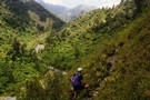
A Total Tararua Traverse
Track
•
8 – 16 days. Medium. One way.
•
Distance: 4.4km away
The length of the Tararuas via the pointy bits, from the Manawatu Gorge at Woodville to the Rimutaka Hill Road ...
More ▶︎
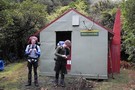
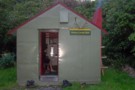
Alpha Hut
Hut
•
Standard Hut (DOC). Capacity: 16.
•
Distance: 4.4km away
The first Alpha Hut was built in 1915, the 2nd replaced it in 1953 ( it was 6 yards inside ...
More ▶︎
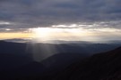
Wellington and Kaikoura peaks from Kime
Photograph
•
Distance: 4.5km away
Wellington and Kaikaoura peaks from near Kime hut. taken Feb 2009.
More ▶︎
Kime Hut - Tararuas
Photograph
•
Distance: 4.6km away
Kime Hut November 2007 on a jaunt to Mt.Hector for the weekend.
More ▶︎
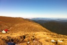
Kime Hut
Photograph
•
Distance: 4.6km away
The highest hut on the Southern Crossing (1400m). Magnificent views north and south. Handy for Mt. Hector. No stove - ...
More ▶︎
Tararua main ridge
Track
•
4 – 8 days. Medium. One way.
•
Distance: 4.6km away
The length of the tracked Tararuas along the main ridge from Mangahao (behind Shannon) to Kaitoke.
For a 'Total Tararua Traverse ...
More ▶︎
Tararua Middle loop
Track
•
3 – 5 days. Medium. Loop track.
•
Distance: 4.6km away
A 4-5 day loop from Otaki Forks following the main ridge of the Tararuas
More ▶︎
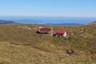
Kime Hut
Hut
•
Standard Hut (DOC). Capacity: 20.
•
Distance: 4.6km away
The highest hut on the Southern Crossing. Nice view of Masterton through the valley. This hut was replaced in 2014 ...
More ▶︎
Kapiti Island Horowhenua Sunset from Kime Tararuas
Photograph
•
Distance: 4.6km away
View of Kapiti Island and the Horowhenua from Kime Hut Tararua Range.
More ▶︎
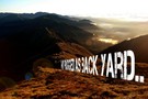
My Rugged As Backyard Desktop BG Wallpaper
Photograph
•
Distance: 4.6km away
A tweaked image from a trip into the Tararuas Feb 2010.
More ▶︎
Kime Hut
Photograph
•
Distance: 4.6km away
Highest hut on the southern crossing Tararuas. Cold no fire
More ▶︎
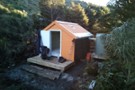
New Kime Hut
Photograph
•
Distance: 4.6km away
Progress on the new Kime Hut near Mt Hector in the Tararua Range. taken on 1/3/2013. The cladding was completed ...
More ▶︎
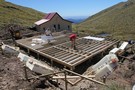
Kime Hut replacement
Photograph
•
Distance: 4.6km away
Builders working on the new Kime Hut (number 3) on 8/2/2013. 20 bunks, lots of insulation and double glazing. better ...
More ▶︎
Descent to Kime Hut...
Photograph
•
Distance: 4.6km away
12 March 2011 - Nice day but the tops were a bit cloudy (funny that!)
More ▶︎
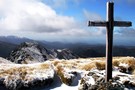
Mount Hector
Photograph
•
Distance: 4.6km away
Memorial Cross on the summit of Mount Hector. Lake Wairarapa in the background and The Beehives on the right. Great ...
More ▶︎
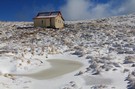
Kime Hut
Photograph
•
Distance: 4.7km away
Kime Hut, Tararua Range near Mt Hector August 2010. One of the coldest huts in the Tararua's
More ▶︎
Kime in mid summer
Photograph
•
Distance: 4.7km away
On a calm sunny day there is no better place
More ▶︎
Mount Hector
Photograph
•
Distance: 4.7km away
Photo taken facing the west coast towards Otaki from the summit of Mount Hector.
More ▶︎
Memorial Cross on Mt Hector September 2012
Photograph
•
Distance: 4.7km away
Memorial Cross on Mt Hector, Tararua Range, looking north east down the Niell Ridge with Winchcombe peak in the distance
More ▶︎
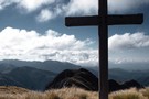
Mt Hector Memorial Cross
Photograph
•
Distance: 4.7km away
View looking towards Winchcombe Peak from Mt Hector in April 2008 during a perfect 3 day Southern Crossing with not ...
More ▶︎
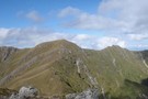
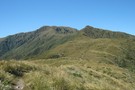
Mt Hector from Fields Peak
Photograph
•
Distance: 4.7km away
View of Mt Hector and surrounds from Fields Peak.
More ▶︎
Kime White Out Winter, Tararuas
Photograph
•
Distance: 4.8km away
The track between Field and Kime Huts in the Tararua Forest Park. A mostly forgettable trip I did with a ...
More ▶︎
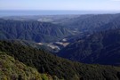
The Tararua Range
Photograph
•
Distance: 4.8km away
Looking along the Main Range, into the heart of the Tararua from Hut Mound
More ▶︎
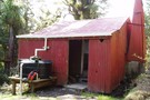
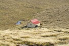
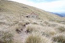
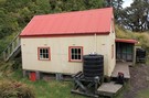
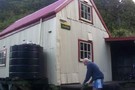
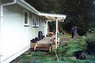
Renata Hut
Photograph
•
Distance: 5.0km away
Renata Hut on the Renata ridge between the old logging road from the Akatarawa summit and Elder Hut. An old ...
More ▶︎
Renata Hut
Hut
•
Standard Hut (DOC). Capacity: 6.
•
Distance: 5.0km away
An older club hut, last of a kind. Opened in 1956.
Unfortunately close to a road end, so popular with people ...
More ▶︎
Bridge Peak looking towards Otaki Forks & Table Top
Photograph
•
Distance: 5.3km away
Track heading out to Otaki Forks from Kime Hut looking down towards Table Top. Early morning with some rain shadow ...
More ▶︎
Bridge Peak looking towards Otaki Forks & Table Top
Photograph
•
Distance: 5.3km away
Track heading out to Otaki Forks from Kime Hut looking down towards Table Top. Early morning with some rain shadow ...
More ▶︎
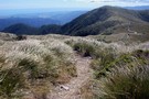
Table Top
Photograph
•
Distance: 5.3km away
View looking north comming down from Kime Hut.Otaki/sea to the left.
More ▶︎
View west from the Tararua Ranges.
Photograph
•
Distance: 5.3km away
View from bridge peak looking west overlooking the Otaki forks, the Otaki river & Otaki at the top.
More ▶︎
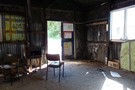
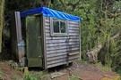
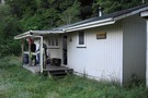
Waiotauru Hut
Photograph
•
Distance: 5.4km away
Interior of Waiotauru Hut, Tararua FP. You really would have to be desperate to want to stay here for more ...
More ▶︎
Waiotauru Hut
Hut
•
Basic Hut/Bivvy (DOC). Capacity: 18.
•
Distance: 5.4km away
Built in the early 70s,tin hut.
More ▶︎
Eastern Hut Hut
Hut
•
Private hut (NA). Capacity: 6.
•
Distance: 5.4km away
Hut operated by the Greater Wellington Regional Council.
Although it is said to be for emergency use only, the 6 bunks ...
More ▶︎
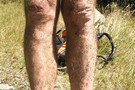
Battered legs
Photograph
•
Distance: 6.0km away
This is the result of running on old bush tracks that are infested with Toitoi and Hook Grass (Bastard Grass)in ...
More ▶︎
Southern Crossing Feb 2010
Photograph
•
Distance: 6.2km away
On a hot and windless day 2. The best weather we could of hoped for. What an awesome trip!
More ▶︎
Winchcombe Bivvy No. 3
Photograph
•
Distance: 7.0km away
From Hutbagger.co.nz "This was built by ex NZFS culler Paul Gush at his home and in April 2021, it was ...
More ▶︎
The Southern Crossing tops
Photograph
•
Distance: 7.1km away
The Southern Crossing from just past Table Top, showing Dennan, Bridge Peak and Hut Mound .
More ▶︎
Tabletop
Photograph
•
Distance: 7.3km away
Snow on the Tararua Ranges above Tabletop 21 SEP 2011
More ▶︎
Mt Kapakapanui
Track
•
1 – 2 days. Medium. Loop track.
•
Distance: 7.4km away
A smaller peak (1102m) in the Tararua Ranges.
More ▶︎
Mount Kapakapanui Possumers Hut
Photograph
•
Distance: 7.4km away
Possumers Hut also known as Thornhills Hut, on Mount Kapakapanui near Waikanae. Still dry inside. There are a couple of ...
More ▶︎

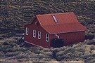
Field Hut
Photograph
•
Distance: 7.6km away
Picture taken as passing through on a day hike from Otaki forks to Mount Hector to see the views & ...
More ▶︎
Field Hut
Hut
•
Standard Hut (DOC). Capacity: 20.
•
Distance: 7.6km away
Built in 1924, there are still signs of the original bush carpentry. Handy for Friday-nighters doing the Southern Crossing over ...
More ▶︎
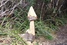
New type of DOC marker?
Photograph
•
Distance: 7.8km away
Ran into this handiwork a couple of days ago when going from Otaki Forks up to Field Hut about 20 ...
More ▶︎
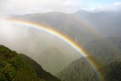
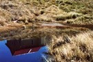
Rainbow under Neill Peak
Photograph
•
Distance: 8.6km away
We were chasing rainbows all morning.
More ▶︎
Tutuwai Hut
Hut
•
Serviced Hut (DOC). Capacity: 20.
•
Distance: 8.8km away
Set on a bank above a river flat (good camping). Gas stoves and running water. Potbelly stove. Well-built modern hut.
More ▶︎
Kaitoke to Greytown via Tutuwai & Mt.Reeves, Tararua Forest Park
Article
•
Distance: 8.8km away
A two day jaunt to clear the head and get a little much needed exercise. Oh and to enjoy some ...
More ▶︎
Kapakapanui Hut 2011
Photograph
•
Distance: 8.9km away
Kapakapanui Hut behind Waikanae. There is a good circuit up the western ridge and down the eastern ridge. Can be ...
More ▶︎
Kapakapanui Hut
Hut
•
Standard Hut (DOC). Capacity: 6.
•
Distance: 8.9km away
Around 2 to 3 Hrs from the Ngatiawa roadend.Acommodates 6 though 8 could fit.Up from the hut past the goblin ...
More ▶︎
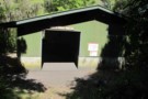
Kapakapanui Hut Exterior
Photograph
•
Distance: 8.9km away
Exterior shot Kapakapanui Hut, Tararua Forest Park
More ▶︎
Kapakapanui Hut
Photograph
•
Distance: 8.9km away
Kapakapanui lodge, the loop is a good day walk, take the south spur up and over .
More ▶︎
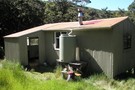
Penn Creek Hut
Hut
•
Standard Hut (DOC). Capacity: 6.
•
Distance: 9.0km away
A standard NZFS hut from the Seventies, has had some recent work done on it.
Add in Field Hut and you ...
More ▶︎
Penn Creek Hut
Photograph
•
Distance: 9.0km away
Penn Creek in July 2009, nice hut except for the leaky chimney!
More ▶︎
Penn Creek
Photograph
•
Distance: 9.0km away
Penn Creek in the Tararua Range which flows into the Otaki River. The sidle track down the Otaki which is ...
More ▶︎
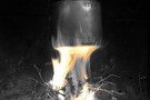
Brew time at Penn Creek
Photograph
•
Distance: 9.0km away
Well earned billy of tea after the slippery descent into Penn Creek from Table Top.
More ▶︎
Cone Hut
Hut
•
Basic Hut/Bivvy (DOC). Capacity: 12.
•
Distance: 9.6km away
An outstanding example of bush carpentry. Built in 1946, renovated using original techniques in 1987. Adzed totara plank sleeping platform, ...
More ▶︎
A billy at Cone Hut
Photograph
•
Distance: 9.6km away
We passed through Cone Hut at about morning tea time, which was really just an excuse to build a small ...
More ▶︎


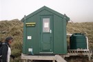
Smith Creek Shelter
Hut
•
Shelter (DOC).
•
Distance: 9.9km away
A small concrete block shelter on Smith Creek at the end of the descent from Puffer Saddle for those crossing ...
More ▶︎