Nearby
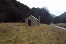
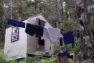
Downie Hut
Downies Hut
Hut
•
Basic Hut/Bivvy (DOC). Capacity: 4.
•
Distance: 466m away
Historic hut on the Matakitaki River, dating back to 1902 or earlier. The hut is perhaps the second oldest in ...
More ▶︎

Blue Lake Hut - Bobs Hut
GPX file
•
Distance: 6.0km away
Blue Lake campsite to Bob’s Hut, via Lake Thompson and D’Urville Pass
An actual, recorded, gpx – the high route section ...
More ▶︎
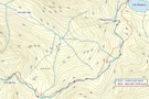
Thompson Pass
GPX file
•
Distance: 6.1km away
Caroline Creek Hut, Upper Waiau Valley to East Matakitaki Hut via Thompson Pass & Unamed Pass
More ▶︎
Thompson Pass
GPX file
•
Distance: 6.1km away
Caroline Creek Hut, Upper Waiau Valley to East Matakitaki Hut via Thompson Pass & Unamed Pass
More ▶︎
St Arnaud to Lewis Pass
Track
•
5 – 9 days. Medium/hard. One way.
•
Distance: 6.1km away
A 5-9 day north-south route from St Arnaud to the Lewis Pass, via Travers Pass, Waiau Pass, Thompson Pass and ...
More ▶︎
Lake Daniels to Lake Rotoroa
GPX file
•
Distance: 6.3km away
Route tracing of Alternate route from the Lewis Pass to St Arnaud
More ▶︎
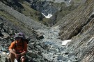
Burn Ck Bivvy
Photograph
•
Distance: 6.3km away
A basic 2 bunk bivvy that has seen better days.
Burn ck is fairly tight and gorgey with plenty of sidling ...
More ▶︎
Burn Creek Hut
Hut
•
Basic Hut/Bivvy (DOC). Capacity: 2.
•
Distance: 6.3km away
The little hut with a steep-pitched roof is located just under the Emily Peaks next to some beech forest. Given ...
More ▶︎

Route Guide: St Arnaud to Lewis Pass
Article
•
Distance: 6.4km away
A 5-7 day north-south route from St Arnaud to the Lewis Pass, via Travers Pass, Waiau Pass, Thompson Pass and ...
More ▶︎
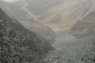
East Matakitaki from David Saddle
Photograph
•
Distance: 6.4km away
East Matakitaki valley from David Saddle
More ▶︎

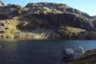
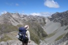
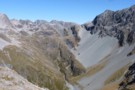
Lake Thompson
Photograph
•
Distance: 6.4km away
A view of the beautiful Lake Thompson, a short distance from Thompson Pass
More ▶︎
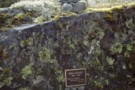
Max Smart memorial plaque, Matakitaki valley
Photograph
•
Distance: 6.5km away
Memorial plaque to Max Smart on the true left of the Matakitaki upriver of the East Matakitaki Hut. The quote ...
More ▶︎
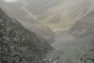
East Matakitaki Valley from David Saddle
Photograph
•
Distance: 6.7km away
East Matakitaki Valley from David Saddle, Nelson Lakes
More ▶︎

Profile : St Arnaud - Lewis Pass
Photograph
•
Distance: 7.6km away
A useful profile of the 100km tramp - with a couple of bad weather alternatives :
1. low route past Speargrass ...
More ▶︎
St Arnaud - Lewis Pass
Article
•
Distance: 7.6km away
A 9-day 100km tramp via the Thompson, D'Urville and 3 Tarns Passes
Feb 2013
More ▶︎
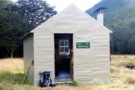
East Matakitaki Hut
Photograph
•
Distance: 7.6km away
beside the river and at the southern end of the flats, we found this 6-berth hut in great condition
Feb 2013
More ▶︎
East Matakitaki Hut
Photograph
•
Distance: 7.6km away
East Matakitaki Hut in the east branch of the Matakitaki Valley.
More ▶︎
East Matakitaki Hut
Hut
•
Standard Hut (DOC). Capacity: 6.
•
Distance: 7.6km away
East Matakitaki Hut (6 bunk, matresses, fireplace, creek water) lies on river flats in the upper Matakitaki valley (east branch). ...
More ▶︎
Upper D'Urville bivi
Hut
•
Basic Hut/Bivvy (DOC). Capacity: 2.
•
Distance: 7.7km away
2 bunk no toilet just a shovel. good base for hunting welcome shelter or last stop before david saddle before ...
More ▶︎
Thompson - D'Urville sidle
Photograph
•
Distance: 8.1km away
Cyan shows our actual route from Thompson Pass to D'Urville Pass. Red is Skiveoff's GPX route (downloadable from this website).
In ...
More ▶︎
Nardoo Hut
Hut
•
Basic Hut/Bivvy (DOC). Capacity: 2.
•
Distance: 8.3km away
Hut above the bushline on the tops between the Glenroy and Matakitaki Rivers.
More ▶︎
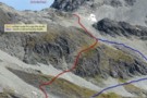
D'Urville Pass
Photograph
•
Distance: 8.3km away
an easier route (red) to D'Urville Pass
Feb 2013
More ▶︎

St James Conservation Area
Place
•
Place. 781.96km2.
•
Distance: 8.6km away
A large new recreational area featuring tussock grasslands, and including the headwaters of the Waiau and Clarence Rivers.
More ▶︎
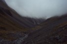
Upper D'Urville valley
Photograph
•
Distance: 8.9km away
Upper D'Urville valley, descending from Thompson Pass towards D'Urville Hut. Nelson Lakes.
More ▶︎
Waiau Pass towards Thompson Pass
Photograph
•
Distance: 9.7km away
Looking nearly due south towards Lake Thompson (blue horizontal strip above my head), a very prominent fault to its right ...
More ▶︎
Thompson Pass & Sth Island Alpine Fault line
Photograph
•
Distance: 9.8km away
A view from Waiau Pass which clearly shows the alpine fault line as it heads south through Thompson Pass.
More ▶︎
Nelson Lakes double figure eight with a reverse twist
Article
•
Distance: 10.0km away
January 2008.
A seven day epic up and over Lake Angelus from Speargrass Hut, then up the Sabine River, over Waiau ...
More ▶︎