Nearby
D'Urville windfall
Nelson Lakes double figure eight with a reverse twist
Article
•
Distance: 2.6km away
January 2008.
A seven day epic up and over Lake Angelus from Speargrass Hut, then up the Sabine River, over Waiau ...
More ▶︎
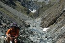
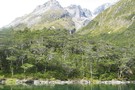
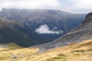
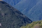
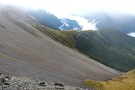
Tarns on range south of Mt Misery
Photograph
•
Distance: 2.6km away
Tarns below pt1609, rapidly losing their emerald colour as mist sets in..
Nearly at the end of a long climb ...
More ▶︎
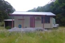
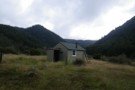
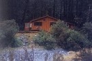
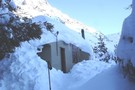
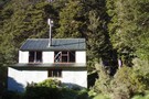
Morgan Hut
Photograph
•
Distance: 2.7km away
The new hut, about 1km further up from the old site.
More ▶︎
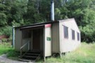
Morgan Hut
Hut
•
Standard Hut (DOC). Capacity: 10.
•
Distance: 2.7km away
Located on the D'Urville River south of Lake Rotoroa.
More ▶︎
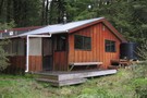
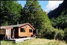
Morgan Hut
Photograph
•
Distance: 2.7km away
Morgan Hut on the D'Urville River. 10 bunks and lots of sandflies.
More ▶︎
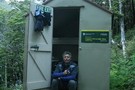
Mount Misery Hut
Hut
•
Basic Hut/Bivvy (DOC). Capacity: 4.
•
Distance: 3.1km away
Mount Misery hut
More ▶︎

Profile : St Arnaud - Lewis Pass
Photograph
•
Distance: 4.2km away
A useful profile of the 100km tramp - with a couple of bad weather alternatives :
1. low route past Speargrass ...
More ▶︎

St Arnaud - Lewis Pass
Article
•
Distance: 4.2km away
A 9-day 100km tramp via the Thompson, D'Urville and 3 Tarns Passes
Feb 2013
More ▶︎
Sabine-Waiau Pass-Thompson Pass-D'Urville
Track
•
5 – 7 days. Easy/medium. Loop track.
•
Distance: 4.5km away
5 day trip accessed by kayak up Lake Rotoroa. Easy bush travel up and down Sabine and D'Urville valleys respectively. ...
More ▶︎
Lake Daniels to Lake Rotoroa
GPX file
•
Distance: 4.7km away
Route tracing of Alternate route from the Lewis Pass to St Arnaud
More ▶︎
D'Urville Hut
Hut
•
Standard Hut (DOC). Capacity: 10.
•
Distance: 5.2km away
Located at the head of Lake Rotoroa.
More ▶︎
Blue Lake Jan 2007
Photograph
•
Distance: 5.2km away
This was a 'rite-of-passage' tramp for my 13 year old son. We helicoptered in to the Waiau Pass and then ...
More ▶︎
Sabine Valley - Blue Lake - D'Urville Valley
Track
•
4 – 5 days. Medium. Circuit.
•
Distance: 5.2km away
A circuit along neighbouring valleys at the hear of Lake Rotoroa, passing the picturesque Blue Lake, and crossing Moss Pass. ...
More ▶︎
D'Urville Jetty
Photograph
•
Distance: 5.5km away
... at the hut. Zoom in and you'll see the sandflies ...
More ▶︎
Blue Lake
Track
•
2 – 4 days. Easy/medium. Return via same track.
•
Distance: 5.6km away
Blue Lake is a small, pretty lake dammed by boulders at the head of the Sabine Valley. Beyond is Lake ...
More ▶︎
Mole Hut
Hut
•
Basic Hut/Bivvy (DOC). Capacity: 4.
•
Distance: 5.9km away
A brilliant hut to visit close to Murchison within the Tutaki Conservation Area, on the edge of Nelson Lakes National ...
More ▶︎
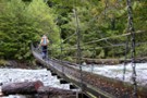
Over the Sabine River
Photograph
•
Distance: 6.2km away
First bridge after Sabine Hut, I think
More ▶︎
Sabine Hut
Hut
•
Serviced Hut (DOC). Capacity: 32.
•
Distance: 6.6km away
Located at the head of Lake Rotoroa. A radio is available for contacting the water taxi service.
More ▶︎
Travers-Sabine
Track
•
4 – 7 days. Medium. Loop track with a road section.
•
Distance: 6.6km away
Two river valleys linked by a straightforward alpine saddle at 1800m
More ▶︎
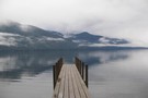
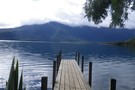
Jetty at Sabine Hut
Photograph
•
Distance: 6.6km away
Early morning - April 2010 - I think it's going to rain...
More ▶︎
Travers-Sabine Saddle
Photograph
•
Distance: 6.6km away
Going over the saddle looking west towards the Sabine Valley - April 2010.
More ▶︎
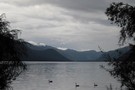
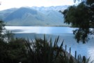
Lake Rotoroa
Photograph
•
Distance: 6.6km away
from the verandah of Sabine Hut - no wonder this hut is popular - Apr 2011
More ▶︎
Sabine Hut
Photograph
•
Distance: 6.6km away
picturesque setting at the head of Lake Rotoroa but prone to crowding at holiday times (and not just by sandflies) ...
More ▶︎
previous West Sabine bridge
Photograph
•
Distance: 6.9km away
washed away in 2012 and replaced with one just upstream of West Sabine hut
More ▶︎
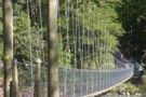
West Sabine Bridge
Photograph
•
Distance: 6.9km away
Feb 2013 - Just upstream from the hut, the new bridge was a pleasant surprise as the DOC website didn't ...
More ▶︎

Route Guide: St Arnaud to Lewis Pass
Article
•
Distance: 7.1km away
A 5-7 day north-south route from St Arnaud to the Lewis Pass, via Travers Pass, Waiau Pass, Thompson Pass and ...
More ▶︎
West Sabine Hut
Hut
•
Serviced Hut (DOC). Capacity: 34.
•
Distance: 7.1km away
Located in the West Branch of the Sabine River, south of Lake Rotoroa.
More ▶︎
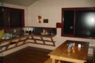
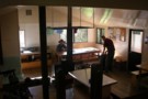
West Sabine Hut
Photograph
•
Distance: 7.1km away
April 2010 - small wood burner inside....but sufficient
More ▶︎

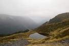
Lake Thompson
Photograph
•
Distance: 7.1km away
A view of the beautiful Lake Thompson, a short distance from Thompson Pass
More ▶︎
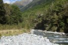
West Sabine River
Photograph
•
Distance: 7.1km away
West Sabine River, below West Sabine Hut, Nelson lakes
More ▶︎
Tiraumea Hut
Photograph
•
Distance: 7.2km away
Standard 6 Bunk DOC hut by Tiraumea River - located in a large clearing about 1.5 hrs from Tiraumea Saddle, ...
More ▶︎
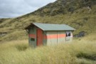
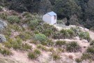
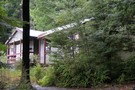
Cupola Basin Hut
Photograph
•
Distance: 7.2km away
Walked in from St. Arnaud and stayed overnight April 2002, as part of the popular Travers/Sabine circuit. I must have ...
More ▶︎
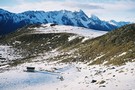
Cupola basin Hut
Photograph
•
Distance: 7.2km away
A snow covered Cupola Basin Hut visited on 6th and 7th July 2008.Stunning views of the surrounding mountains make the ...
More ▶︎
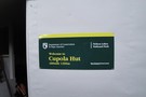
Cupola basin Hut
Hut
•
Standard Hut (DOC). Capacity: 8.
•
Distance: 7.2km away
A hut on the bushline with great views, well worth the up-hill grunt to get there.Even more spectacular when visited ...
More ▶︎
St Arnaud to Lewis Pass
Track
•
5 – 9 days. Medium/hard. One way.
•
Distance: 7.3km away
A 5-9 day north-south route from St Arnaud to the Lewis Pass, via Travers Pass, Waiau Pass, Thompson Pass and ...
More ▶︎
Waiau - Clarence Pass Lake Tennyson Circuit
Track
•
4 – 5 days. Medium/hard. Loop track.
•
Distance: 7.5km away
A challenging 4-5 day circuit in the St. James Conservation Area / Nelson Lakes National Park featuring two alpine pass ...
More ▶︎
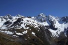
Mt Hopeless 2278m Nov 2012
Photograph
•
Distance: 8.0km away
This picture of Mt Hopeless 2278m was taken on a perfect morning from a knob above the Cupola Basin hut. ...
More ▶︎
Nelson Lakes - Angelus to Sunset Saddle
GPX file
•
Distance: 9.5km away
Route marked by cairns from Angelus Hut to Sunset Saddle. (The first part of the route to Hopeless Creek and ...
More ▶︎
Scree beside the Cedric Track
Photograph
•
Distance: 9.7km away
looking up the Sabine Valley from the Cedric Track - Feb 2013
More ▶︎
Hopeless Creek Hut
Hut
•
Standard Hut (DOC). Capacity: 6.
•
Distance: 9.7km away
An older , little used hut off the Travers Valley leading to Sunset Saddle and Angelus Hut.
More ▶︎
Hopeless Hut
Photograph
•
Distance: 9.7km away
A six bunk hut situated near Hopeless Creek, which is a tributary of the Travers River. The lower story is ...
More ▶︎
Mt Franklin
Photograph
•
Distance: 9.9km away
taken on the descent from Travers Pass into the E Sabine River - Apr 2011
More ▶︎