Nearby
Rimutaka Forest Park
Mt Matthews
Track
•
1 – 2 days. Medium. Loop with road section.
•
Distance: less than 100m away
A long ridge walk to a fine river valley allowing access to the highest mountain close to Wellington city.
More ▶︎
Route Guide: Mt Matthews
Article
•
Distance: less than 100m away
Mount Matthews is the closest big peak (941 metres) to Wellington City.
More ▶︎
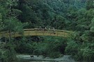
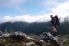
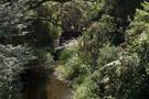
Mt Mathews, Mukamuka stream below
Photograph
•
Distance: 758m away
2nd July 2009. Mt Mathews on the saddle looking down onto the Mukamuka stream
More ▶︎
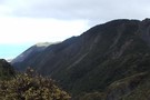
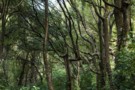
Rimutaka Range
Photograph
•
Distance: 1.3km away
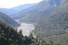
Mt Mathews looking down onto Orongorongo river. July 2009
More ▶︎

Rimutaka Range
Photograph
•
Distance: 1.3km away
Mt Mathews looking down onto Orongorongo river. July 2009
More ▶︎
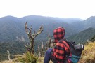
South Saddle Rimutaka Ranges
Photograph
•
Distance: 1.5km away
Looking south from the South Saddle below Mt Matthews.
More ▶︎
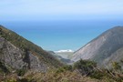
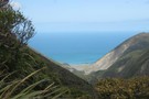
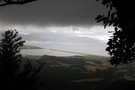
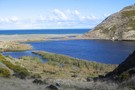
Palliser Bay
Photograph
•
Distance: 1.5km away
Looking east from the South Saddle down the valley to Palliser Bay on the way to Mt Matthews. Mukamuka stream ...
More ▶︎
A Total Tararua Traverse
Track
•
8 – 16 days. Medium. One way.
•
Distance: 2.1km away
The length of the Tararuas via the pointy bits, from the Manawatu Gorge at Woodville to the Rimutaka Hill Road ...
More ▶︎
Tararua Forest Park
Place
•
Conservation Park. 1165.35km2.
•
Distance: 2.9km away
The first of New Zealand's forest parks, this is a large and famous park near Palmerston North and Wellington. Highest ...
More ▶︎
Jans Hut
Hut
•
Serviced Hut (DOC). Capacity: 9.Bookings required.
•
Distance: 2.9km away
Locked sole-occupancy hut on the Orongorongo River.
The hut has a gas cooker, utensils, pots, pans, crockery, flush toilet, and ...
More ▶︎
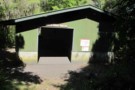
Haurangi Hut
Hut
•
Serviced Hut (DOC). Capacity: 10.Bookings required.
•
Distance: 3.0km away
Locked sole-occupancy hut on the Orongorongo River.
The hut has a gas cooker, utensils, pots, pans, crockery. Lighting, toilet paper, matches ...
More ▶︎
Turere Lodge
Hut
•
Serviced Hut (DOC). Capacity: 32.Bookings required.
•
Distance: 3.1km away
Locked hut on the Orongorongo River. The hut has 4 sole-occupancy bunk rooms which must be booked. Each bunk room ...
More ▶︎
Oaks Hut
Hut
•
Removed!
•
Distance: 3.2km away
A "bush cabin" - book at the ranger's station at the entrance to the park. Ford the river straight over ...
More ▶︎
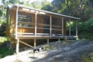
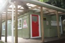
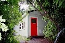
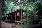
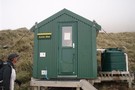
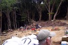
The new Papatahi Hut
Photograph
•
Distance: 3.2km away
A 'bush cabin' - read bookings-only, single occupancy hut - in the Rimutaka Range. A brief climb out of the ...
More ▶︎
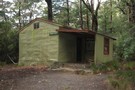
Papatahi (Shamrock) Hut
Hut
•
Serviced Hut (DOC). Capacity: 10.Bookings required.
•
Distance: 3.2km away
Locked sole-occupancy hut, formerly known as Shamrock hut. Located on the Orongorongo River.
More ▶︎
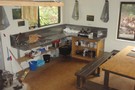
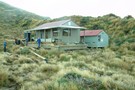
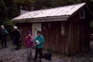
Haurangi Hut
Photograph
•
Distance: 3.3km away
The hut is well kitted out with cooking utensils, crockery and cutlery. There is also a sink with running water, ...
More ▶︎
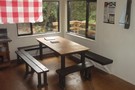
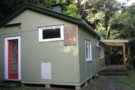
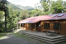
Haurangi Hut
Photograph
•
Distance: 3.3km away
The hut has a good sized table and adequate seating for all staying there.
More ▶︎
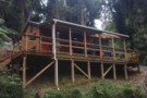
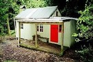
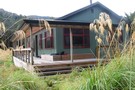
Haurangi Hut view from outside
Photograph
•
Distance: 3.3km away
A view of the new Haurangi Hut, looking up from the site of the original hut
More ▶︎
Raukawa Lodge
Hut
•
Serviced Hut (DOC). Capacity: 14.Bookings required.
•
Distance: 3.4km away
Locked sole-occupancy hut on the Orongorongo River.
The hut has a gas cooker, utensils, pots, pans, crockery, flush toilet, and ...
More ▶︎
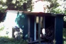
Bains hut july 09
Photograph
•
Distance: 3.7km away
built 1943 hutt valley tramping club soon to be removed
More ▶︎
Boar Inn
Hut
•
Serviced Hut (DOC). Capacity: 4.Bookings required.
•
Distance: 3.9km away
Locked sole-occupancy hut on the Orongorongo Track.
More ▶︎
Raukawa Lodge, Rimutakas.
Article
•
Distance: 4.0km away
An well graded and easy 2 hour hike into the Orongorongo Valley suitable for kids.
More ▶︎
Paua Hut
Hut
•
Club hut (Wellington Tramping and Mountaineering Club). Capacity: 10.Bookings required.
•
Distance: 4.0km away
Hut in the Orongorongo Valley, Rimutaka Forest Park, maintained by the Wellington Tramping and Mountaineering Club. The Paua Tramping Club ...
More ▶︎
Lake Ferry from Papatahi Crossing
Photograph
•
Distance: 5.1km away
Dubious weather allows a spectacular glimpse down the Wairarapa Coast over Lake Ferry. Feb 2012.
More ▶︎
Tararua main ridge
Track
•
4 – 8 days. Medium. One way.
•
Distance: 5.5km away
The length of the tracked Tararuas along the main ridge from Mangahao (behind Shannon) to Kaitoke.
For a 'Total Tararua Traverse ...
More ▶︎
Route Guide: Kaitoke - Holdsworth
Article
•
Distance: 5.7km away
The classic route between Kaitoke in the south of the Tararua Ranges and Holdsworth (about halfway up the eastern side ...
More ▶︎
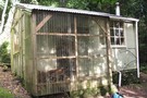
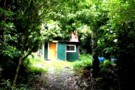
new shamrock hut
Photograph
•
Distance: 5.7km away
replacement for shamrock hut orongorongo valley quite a lot higher than the existing hut wouldnt want to go to the ...
More ▶︎
Kaitoke - Holdsworth (Totara Flats)
Track
•
2 – 3 days. Easy. One way.
•
Distance: 5.8km away
Three low bush saddles separate two long and scenic river valleys.
More ▶︎
Wharepapa Hut
Hut
•
Basic Hut/Bivvy (DOC). Capacity: 5.
•
Distance: 5.9km away
Wharepapa Hut - a large 5-bunk (8 mattresses) hut 6km from the Wairarapa roadend in the Rimutakas. River water, open ...
More ▶︎
Wharepapa Hut
Photograph
•
Distance: 5.9km away
Pleasant 5-bunker (8 matresses) on the Papatahi crossing, or an easy-moderate about 1.5-3 hours walk in from the Western Lake ...
More ▶︎
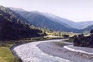
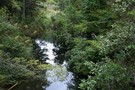
Orongorongo River
Photograph
•
Distance: 6.0km away
Orongorongo River heading north 2nd July 2009. Morning cloud.
More ▶︎
Southern Crossing of the Tararuas
Track
•
3 – 4 days. Medium. One way.
•
Distance: 6.0km away
A classic, must-do walk that climbs through bush onto exposed, high tussock tops, traversing them back into bush at Alpha ...
More ▶︎
East Harbour Regional Park
Place
•
Place.
•
Distance: 6.2km away
Forest and wetlands on the eastern side of Wellington Harbour.
More ▶︎
Smith Creek up close and personal.
Photograph
•
Distance: 6.7km away
A shot from my misguided adventure into Smith Creek. Still - it was worth it for this shot and hey, ...
More ▶︎
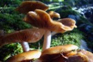
Smith Creek track mushrooms.
Photograph
•
Distance: 6.7km away
Shot these amazing looking guys on my recent trip through the Tauherenikau Valley and over Mt.Reeves.
More ▶︎
Kaitoke to Greytown via Tutuwai & Mt.Reeves, Tararua Forest Park
Article
•
Distance: 6.7km away
A two day jaunt to clear the head and get a little much needed exercise. Oh and to enjoy some ...
More ▶︎
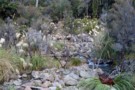
Graces Stream Campsite
Campsite
•
Backcountry Campsite (DOC). 10 spaces.
•
Distance: 6.9km away
This Catchpool Valley campsite is a short walk in, leaving the crowds and caravans behind, but still handy to the ...
More ▶︎
Graces Stream, Catchpool Valley
Photograph
•
Distance: 7.1km away
A walk-in campsite is about 1km up this stream.
More ▶︎
Tawa forest
Photograph
•
Distance: 7.3km away
Nga Taonga Nature Walk in the Catchpool Valley.
More ▶︎
Catchpool Valley Campsite
Campsite
•
Standard Campsite (DOC). 150 spaces.
•
Distance: 7.6km away
Extensive drive-in campsite in the Catchpool Valley: a hub for short walks and overnight trips into the Orongorongo Valley.
The campsite ...
More ▶︎
Lake Kohangapiripiri
Photograph
•
Distance: 7.7km away
A hidden Wellington jewel. About an hours walk south of Eastbourne past Burdans gate. Well worth the effort. Be warned....it's ...
More ▶︎
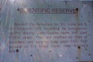
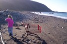
the mesurements show the age of this sign
Photograph
•
Distance: 8.0km away
sign on track at seal colony Palliser Bay coast
More ▶︎
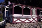

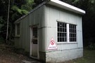
Smith Creek Shelter
Hut
•
Shelter (DOC).
•
Distance: 9.5km away
A small concrete block shelter on Smith Creek at the end of the descent from Puffer Saddle for those crossing ...
More ▶︎

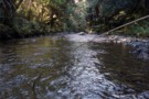
Feeder Creek Tauherenikau Valley nr Tutuwai Hut
Photograph
•
Distance: 10.0km away
Feeder Creek Tauherenikau Valley nr Tutuwai Hut - the track crosses an open expanse of rocky river bed for a ...
More ▶︎