It lies at the southern side of the Rimutaka Forest Park across Wellington Harbour (Port Nicholson) from the city. As the crow flies it is less than 20 kilometres away from the city centre but nearer to 40 kilometres away by land.
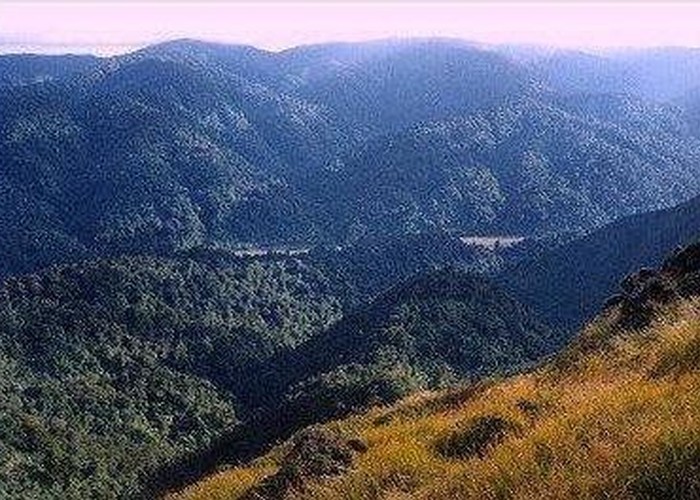
The Rimutaka Forest Park consists of the ranges either side of the Orongorongo River in the south (to about 5 kilometres from the river outlet) and the slopes above Lake Wairarapa to the Rimutaka Hill Road in the north - at this point the Tararua Forest Park starts. Note that a large portion of the headwaters of the Orongorongo River and the neighbouring Wainuiomata River are in a water catchment area with entry prohibited. The main entry to the park is via the Catchpool Valley about 9 kilometres from Wainuiomata along the sealed Coast Road. At the entrance to the park there is the ranger headquarters with lots of information and a small shop. This is where you can book one of the bush cabins (gas cooking and lighting, pots and pans supplied, all with either an open fireplace or pot belly stove). The ranger headquarters also has a telephone. It is worth a stop here for the display about the history and features of the park.
There is a good sealed road that follows the Catchpool Stream for a couple of kilometres to a large carpark. There are picnic and camping areas all along the road. This is the area most likely to be crowded in summer.
The other entrances to the park are from Wainuiomata along either the McKerrow or Whakanui Tracks; along the Rimutaka Incline Track from Kaitoke in the north or along a couple of tracks from the Wairarapa. There is also a four-wheel drive track up the river from the coast - it is used by hunters and fishermen coming up to use the private baches (huts) in the valley and scientists staying at the field research station.
From the Catchpool there is easy access to the Orongorongo via the Orongorongo Track (1.5 to 2 hours). There is a picnic area here (may be crowded) and a couple of camping spots further up the river. You can bag Mt Matthews in a long summer's day from the carpark - this can take up to 10 hours in a rather rushed day. The alternative is to walk into the valley one day, camp at the foot of Mt Matthews - climbing Mt Matthews the next day before walking out to Catchpool.
Access
Start in Hine Road or Sunny Grove, Wainuiomata. The Catchpool ranger station is 9 kilometres south from Wainuiomata down the sealed Coast Road.
Sunny Grove to the Orongorongo Valley
The start of the Whakanui Track into the Rimutakas is at the top of Sunny Grove, Wainuiomata. However if you use the bus to travel to Sunny Grove or want to leave your car then there is a carpark at the foot of the street (the bus also stops near here). From there you can either walk up the street or go over a field to another start for the track.
From the top of Sunny Grove, the track follows a stream up a small valley and then crosses the stream to rise up the other side of the valley. Soon you walk around the end of a ridge to a T-junction where you should turn right. Just ahead is a pair of offset fences forming a sort of kissing gate - the Rimutaka Forest Park begins here.
From the bottom of Sunny Grove, the track starts as a bulldozed fire-break that climbs up above the houses on the street. A lot of the time along this section is spent dodging gorse. After about 10 minutes the track climbs up a final steep bit and enters into real bush. Soon you contour around the head of a gully to a T-junction where the track from the other entrance is reached.
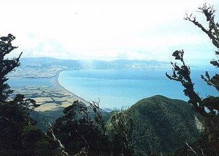
After the track enters the park, it climbs steadily along the side of the ridge for less than a kilometre. The water you can sometimes hear below you is Skerrets Creek. The track is dry with fresh gravel on it and well-benched into the hillside. Eventually the track leads onto the ridge top and continues uphill for another kilometre (not as steep but a little muddy on some flat sections). Then it sidles along the side of the ridge leading to McKerrow. Just before the junction with the McKerrow Track, there is a viewpoint with vistas over Moores Valley to the hills of the Hutt Valley and over Wainuiomata to the harbour. Wellington City can be seen through a gap in the trees a little further around to the west. The height of the track (640m) means that the surrounding hills no longer block the views.
McKerrow Track is slightly rougher than the Whakanui with more varied views. However it ends up at either Catchpool Stream or about an hour downriver from where we want to go. If you have time then you can rush up the track for 500 metres where a clearing lets you see over the harbour and Wellington.
The Whakanui Track goes straight on from the junction to a saddle at the head of the Turere Stream. A route departs to the left back down into Wainuiomata. The track now swings south to contour well above the stream for over a kilometre. This section can be done fairly fast (30-40 minutes) due to good footing. Where the track crosses over the top of slips there are occasions to have a look west to the McKerrow ridge or downstream to the river. The path gains the top of the ridge about 300 metres after a bit of a zigzag. Here a choice of routes can be made.
If you want to get to the river fairly fast then continue southwards along the ridge (the Whakanui Track). This is a fairly good track and easy to follow (especially since it just goes along the top of the ridge). Near the end of the ridge there are a couple of patches where the track drops down steep and slippery banks that need a little care in the wet. Expect to take about 2 hours down to the river.
For the more adventurous, there is a route down the east Whakanui ridge that provides a longer, rougher and more rewarding few hours. Head north along a thin path marked mostly with ties on the trees (look for a yellow tie on a tree just north of the Whakanui Track for the start of the route). The path rises gently for 500 metres to a point marked as 711m high on the map. One hundred metres further on, you come to a junction where a path branches to the right. There are some small hand written signs on the trees saying that ahead is a route down to Wainuiomata, to the right is the east Whakanui ridge route and behind you is the Whakanui Track. Turn to your right (east).
The route drops about 100m to a clear patch at the saddle between George Creek and Whakanui Stream. Southwards there is a glimpse of Mt Matthews over the stream and ridge. Ahead you can see the ridge up which the route travels - this is about a 200m climb. To the north stretches the valley of the Wainuiomata River and its bush-clad slopes. Go straight on and up the ridge (sometimes steeply).
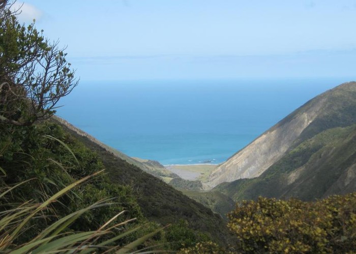
After about an hours fairly hard walking the route tops out at the 800m mark (just). By now the bush around you is fairly primeval - smallish twisting trees covered with moss. Larger and more elegant trees await you as the route descends along the ridge. It takes about 2 hours from this point to get to the river. At about the halfway mark there is another route that drops down a spur to the stream and follows it down to the Orongorongo. As the route gets close to the river there is a nice viewpoint showing the river in its gravel bed wandering down the valley. There is one last bit of difficulty as the route drops over a cliff - overcome by scrambling on tree roots before descending right down to the stream. You end up just across the stream from the end of the Whakanui Track.
The next objective is to find a campsite for the night. The best place is actually beside the Mt Matthews Track. Ford the river just above the Whakanui Stream - usually no more than knee-high. Then follow the river upstream along the bank (if the river height and vegetation allow) or if you feel better following a track, drop downstream a few metres and stroll among a clear section to the 4-wheel drive track. Either way, the next stream meeting the river is the Matthews Stream with a clear path leading into the bush and to the private Baines Hut. Go straight past the hut to where the path continues through a fine stand of trees. After about 10 minutes walking (and an easy ford of the stream) the path reaches the campsite. This is a grassy ledge big enough for 2 or 3 tents with a fireplace blocked out with stones.
Alternatively you can camp by the Orongorongo River. The nearest official campsite is half an hour downstream - follow the river (forded a couple of times) or cross the Whakanui Stream to the Big Bend track (this provides dry-foot access up and down the valley).
Mt Matthews and out
If you have camped by the Orongorongo then walk up river to Baines Hut and join the Mt Matthews Track. Just after the other campsite the track crosses the Matthews Stream and wanders up to a small creek. The track meets the foot of a ridge beyond the creek and starts to climb steadily (about 200m over the next 500 metres). It is a bit steep in sections but nothing to worry about. Once on the ridge proper, the track crosses a small knob and is fairly flat over the next 400 metres. You are now at the foot of another climb - slightly steeper than the first but with plenty of tree roots providing steps and handholds.
Less than 2 hours from the river the track meets a junction where a branch leads off to the South Saddle. This can be taken if you want - the ridge up from the saddle back to the track is easily climbed. However the usual track continues steeply upwards until it gets to a clearing on a knob above the saddle (you are now at the 600m mark). This is a good spot for a break since there are good views back into the Orongorongo and over the saddle down Mukamuka Stream to the Cook Strait. There is even a glimpse of Wellington if the weather is clear enough.
Take a good break because the steepest section of the track is ahead. Follow the track up the ridge to where it disappears back into the bush. Here the track is full of gravel from the eroded sections higher up. Struggle up a clay and rotten rock bank to a chest high enclosure. There are enough tree roots and branches to either side to give handholds and allow you to haul yourself to the top. Beyond this obstacle the track takes a small zigzag and then heads straight up the ridge - climbing 200m over the next 400 metres. It tries to zigzag a bit but since it is constrained by slips on either side of the ridge, these are not very large.
Eventually the slope levels off at the 800m contour and you can now enjoy the delightful moss-clad bush as the track winds and ascends along the summit ridge. A sign that the summit is near is an frustrating drop off the side of the ridge and a final steep climb back up. You can see the big slip this avoids by bush-bashing carefully a few metres down the ridge. Another few metres up the ridge and the bush vanishes from the left revealing the summit (marked by a metal pole). There is enough of a clearing here for a small group to have a sit down for lunch. You should have reached the summit about 3 hours after leaving the river. If the weather permits, the views are great with the green-clad hills of the Rimutakas spreading northwards and the Wairarapa Plain (and lake) extending to the east. A better view can be seen be walking a little along the ridge, clambering through and around the surprising large fallen trees (probably a legacy of the big storm in 1936). There is a larger clearing here with a marvellous view of Palliser Bay and Lake Onoke backdropped by the Haurangi Range.
After lunch, return to the knob above the South Saddle and then continue down - possibly detouring to the saddle if you did not pass that way before. Your knees may take a bit of punishment as you descend the steep track but there is always the nice cold Orongorongo River waiting to cool them down. Plan on a 2 hour descent. Remember to pick up your camping gear and then head off down river. The quickest (1 hour) option is to head down the river using the 4-wheel drive track where possible. This involves 3-4 river crossings (depending on where the winter floods have moved the river). Alternatively, you can ford the river just once and pick up the Big Bend Track for a drier, slower (1.25 hours) walk.
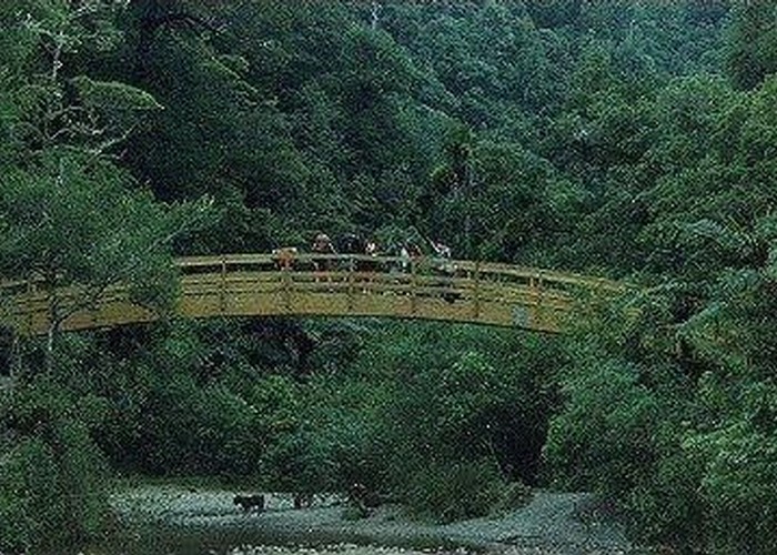
The junction of the river and the Turere Stream is easily recognised by the impressive arc of the wooden bridge. This is a good spot for an afternoon break with some picnic areas (seats and fireplaces with metal hangers to boil the billy) and nice modern toilets.
Leave the river along the Orongorongo Track (start by crossing the bridge). The track is reasonably level after the initial zigzags up onto the ridge top (much better than the old "Jacob's Ladder" track). If you really push it you can get to the Catchpool carpark in less than an hour. However the walk is nice enough to encourage a slower, more enjoyable pace. The track is well-laid out with good bridges and steps where needed (intended to give families good access to the Orongorongo valley).
If you need to walk down to the rangers HQ (e.g. to use the telephone) then you can cut off a lot of the road walking by crossing the Catchpool Stream on a bridge and following a nature walk along the north of the stream to about 500 metres of the building.