Nearby
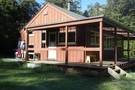
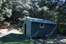
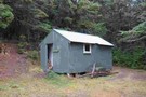
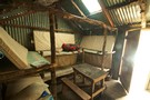
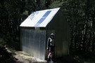
Cass Saddle Hut
Cass Saddle Hut
Photograph
•
Distance: less than 100m away
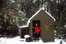
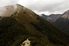
... Heavy summer snow on New Year's Eve!
More ▶︎
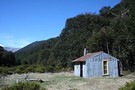
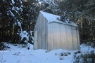
Cass Saddle Hut
Hut
•
Basic Hut/Bivvy (DOC). Capacity: 4.
•
Distance: less than 100m away
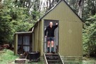
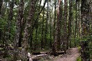
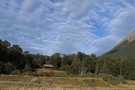
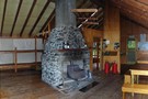
An old Forest Service hut on the Cass-Lagoon Saddle Track, built in 1953. The hut is located just below the ...
More ▶︎
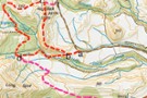
Cass-Lagoon Saddle
Track
•
2 days. Medium. One way.
•
Distance: less than 100m away
This classic route from Cass to Cora Lynn Road circles the Black Range to form an open loop, and a ...
More ▶︎
Craigieburn Forest Park
Place
•
Conservation Park. 441.65km2.
•
Distance: 1.3km away
A small park south of Arthur's Pass National Park including a series of ski fields. Highest point: 2141m (Mt Avoca).
More ▶︎
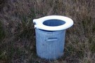
Bush toilet
Photograph
•
Distance: 1.3km away
I found this toilet when I was camping at the start of the Cass saddle track and thought it would ...
More ▶︎
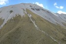
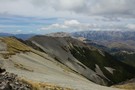
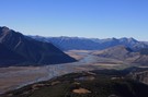
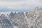
Cass Saddle
Photograph
•
Distance: 1.3km away
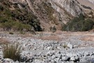
Looking across the Cass Saddle from ridge on North Side.
More ▶︎
Cass Saddle
Track
•
1 day. Easy/medium. One way.
•
Distance: 1.5km away
From the car park at the east end of the Cass road bridge, follow the vehicle track next to the ...
More ▶︎
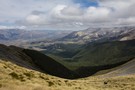
Camp Saddle
Photograph
•
Distance: 3.3km away
The view south, down Camp Stream, Craigieburn Range.
More ▶︎
Camp Saddle / Lyndon Saddle circuit
GPX file
•
Distance: 3.4km away
A loop in Craigieburn Forest Park, leading up onto a spur of the Craigieburn Range.
This route leads up the Broken ...
More ▶︎
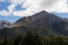
Camp Saddle / Lyndon Saddle spur
Photograph
•
Distance: 3.5km away
Once up on Camp Saddle, it's a straightforward ridge cruise following the arc to the left.
More ▶︎
Mount Wall
GPX file
•
Distance: 3.9km away
A circuit from the Broken River locked gate up onto the Craigieburn Range, along to Mount Wall, and down. Points ...
More ▶︎
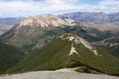
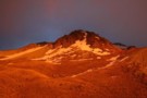
Mount Wall
Photograph
•
Distance: 4.6km away
1874m peak on the Craigieburn Range. The Broken River Ski Club occupies the valley to the right.
More ▶︎
Mount Wall, Craigieburn Range
Track
•
1 day. Medium/hard. Return by the same track.
•
Distance: 4.6km away
Day walk to a summit overlooking the Broken River Ski Area.
More ▶︎
Camp Saddle / Lyndon Saddle spur
Photograph
•
Distance: 4.7km away
Scree slope leading down to Lyndon Saddle and Helicopter Hill. Over the highway is the yellow Broken Hill, with the ...
More ▶︎
Helicopter Hill Circuit
Track
•
Easy/medium. Loop track.
•
Distance: 5.3km away
This circuit in Craigieburn Forest Park knits together several different tracks, and visits the summit of Helicopter Hill (1256m).
More ▶︎
Helicopter Hill
Photograph
•
Distance: 5.3km away
From Lyndon Saddle, the climb to the small summit is quick and easy (1256m).
More ▶︎
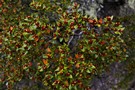
Beech flowers
Photograph
•
Distance: 5.6km away
Bright red mountain beech flowers on Helicopter Hill, Craigieburn Forest.
More ▶︎
Hamilton Hut
Hut
•
Serviced Hut (DOC). Capacity: 20.
•
Distance: 6.4km away
A large hut on the Cass-Lagoon Saddle Track. The hut is well situated on a terrace above the wide Hamilton ...
More ▶︎
Hamilton hut
Photograph
•
Distance: 6.4km away
Hamilton hut, 20 bunks and very cosy. Loads of sandflies but well equipped with nets on the doors to keep ...
More ▶︎
Hamilton Hut - Dec 2009
Photograph
•
Distance: 6.4km away
Exterior shot of Hamilton Hut in December 2009.
More ▶︎
Craigieburn Shelter campsite
Campsite
•
Basic Campsite (DOC). 20 spaces.
•
Distance: 6.8km away
Popular campsite on the banks of Cave Stream in Craigieburn Forest Park, with a number of easy walking tracks nearby. ...
More ▶︎
Complete and Final Version of Craigieburn Double Crossing
Article
•
Distance: 7.1km away
Double crossing of the Craigieburn Range from Hogs Back MTB trail over to Hamilton Hut, then return via Mt Cheeseman ...
More ▶︎
Double Crossing of Craigieburn Range
Photograph
•
Distance: 7.1km away
Queens Birthday weekend trip, combined with scenic tour down the Harper to Mystery Tarn, on the Clay Range.
More ▶︎
Way out, Cass Lagoon Saddle
Photograph
•
Distance: 7.3km away
Hamilton Hut is so nice. Great view.Will be back!!
More ▶︎
Circuit of Broad Stream, Harper Saddle, Lagoon Saddle, Mangos Creek, Broad Stream
Article
•
Distance: 7.4km away
A 2 day circuit in Craigieburn Forest Park, crossing 2 low saddles above the bushline and travelling in easy, pleasant ...
More ▶︎
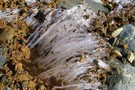
Kammeis, Ice needles
Photograph
•
Distance: 7.5km away
These are ice needles that form under little stones and pieces of dirt and lift them up perpendicular to the ...
More ▶︎
West Harper Hut
Photograph
•
Distance: 7.6km away
Historic hut on the Cass-Lagoon Saddle Track.
More ▶︎
West Harper Hut
Hut
•
Basic Hut/Bivvy (DOC). Capacity: 5.
•
Distance: 7.6km away
An historic hut on the Harper River with axe-cut beams, canvas bunks and a dirt floor. Although basic, this hut ...
More ▶︎
Bealey Hut
Photograph
•
Distance: 7.7km away
A tidy little hut at the Cora Lynn end of the Cass-Lagoon Saddle Track.
More ▶︎
Bealey Hut
Hut
•
Basic Hut/Bivvy (DOC). Capacity: 6.
•
Distance: 7.7km away
A tidy hut near the end of the Cass-Lagoon Saddle Track. The hut has six bunks (most, but not all, ...
More ▶︎
Bealy hut
Photograph
•
Distance: 7.8km away
Arthurs Pass end of the Lagoon Saddle track 5 minutes from the Cora Lynn carpark.
More ▶︎
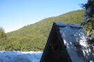
Lagoon Saddle Shelter
Hut
•
Basic Hut/Bivvy (DOC).
•
Distance: 8.7km away
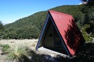
An A-frame day shelter located in a sunny clearing near Lagoon Saddle on the Cass-Lagoon Saddle Track. The Lagoon Saddle ...
More ▶︎
Bealey Spur Hut
Photograph
•
Distance: 8.7km away
Hut is located bottom centre of picture, in the clearing.
More ▶︎
Bealey Spur - Jordan Saddle - Waimakariri River
Track
•
1 – 2 days. Medium/hard. Loop track with a road section.
•
Distance: 8.7km away
A long day trip with great views from open tops travel, a descent down a stream and beginning and ending ...
More ▶︎
Bealey Spur
Track
•
1 – 2 days. Easy/medium. One way.
•
Distance: 8.7km away
Gentle climb with generous views over Arthurs Pass and the Waimakariri River. The track visits an historic musterers' hut framed ...
More ▶︎
Bealey Spur shortcut
GPX file
•
Distance: 9.1km away
A side track that bypasses Cloudesley Road.
More ▶︎
Hogs Back Circuit
Track
•
Easy. Loop track.
•
Distance: 9.5km away
Great views of the Cass basin and surrounding mountain ranges.
More ▶︎
Hogs Back Circuit
Photograph
•
Distance: 9.5km away
A variation of the Hogsback mountain bike track. The mtb track is roughly marked as s-d-c-t. The walking circuit is ...
More ▶︎
Lagoon Saddle hut in the Snow
Photograph
•
Distance: 9.7km away
Lagoon Saddle hut on a snowy winters day
More ▶︎
Lagoon Saddle Hut
Photograph
•
Distance: 9.7km away
When you stop off at the Lagoon Saddle Shelter, this shiny hut glints through the trees from across the creek.
More ▶︎
Lagoon Saddle Shelter
Photograph
•
Distance: 9.7km away
A small A frame day shelter near Lagoon Saddle.
More ▶︎
Lagoon Saddle Hut
Hut
•
Basic Hut/Bivvy (DOC). Capacity: 2.
•
Distance: 9.7km away
A shiny corrugated iron hut across the creek from the shelter near Lagoon Saddle. The hut is tidy, features shelving ...
More ▶︎
View of Torlesse Gap from the west
Photograph
•
Distance: 9.8km away
The well recognised landmark on the Torlesse Range can easily be seen from the top of Broken Hill in the ...
More ▶︎