
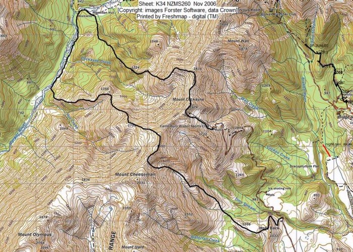
Double Crossing of the Craigieburns/Mystery Tarn
The weather forecast was indicating fine days on the Saturday and Monday of QB weekend but some rain on the Sunday which effectively gave us only a 2 day option. I was also keen to spend the 2 nights in a cozy hut. The problem is that so many trips we want to do require 4 days, not 3 and at this time of the year, there’s only 9 hours of daylight so that’s a further limiting factor. The Canterbury foothills looked as though they might be spared from most of the rain. I suggested this trip and opined it might be fine enough to do a day trip down the Harper River to the Pinnacles. After 2 evenings of scouring the maps, Frank couldn’t find a more acceptable option so was OK to go with mine.
We packed on the Friday and headed off on Saturday, arriving at the Hogs Back MTB trail around midday. At the road end we enjoyed a bit of vegetable tart from the Yello Shack. I’m keen on having lunch before I head off as I find my tramping lunches not that appetizing and it helps keep my pack a bit lighter, not having to carry lunch for the first day. Our packs were heavier than usual as we had the plastic climbing boots, gaiters, crampons and ice axes. With the predicted freezing level it would probably snow on Sunday if it did precipitate but I was hoping there would be sufficient rain shadow effect for us to miss any rain etc.
Frank reckoned wearing the plastic boots straight away would be fine so my 14kg pack got a bit lighter immediately. We carried sandals as where we planned to drop down to the Harper River meant we would probably be doing some river crossing while travelling upstream to Hamilton Hut. I’d planned to come down the Mt Cheeseman Ski Field road to spare the aging knees from a sustained descent on tussock and the sandals would be ideal for that, sparing toes from being mushed in our plastic boots.
The route I’d chosen to go up to the Craigieburn ridgeline looked very gentle and turned out to be so. We started up the Hogs Back trail, travelled along a open broad spur, and crossed the middle tributary of Tims Stream in sparse beech forest. Here I filled a water bottle as there may not have been water in the basins we were heading to. I’ve been in this area about 3 times assisting Ray Goldring running the Above the Bushline courses for Teachers College. We emerged into a shallow open gully and headed up a gentle spur to avoid a steep climb up the nose of the spur we were initially travelling along. Where this little spur abutted into the bigger spur, I sidled to gain a saddle. Frank took a slightly steeper approach and I waited at a good vantage point for him as he’d had a bit more height gain and his pack weighed 10kg more than mine as is usually the case.
We mozied along to a broad saddle then traversed through tussock on a little animal trail to the broad basin where Ray used to have the group camped after they’d constructed various forms of snow shelters. There was plenty of water in the icicle-fringed stream. I suggested we ascend to the next basin via a gentle slope running from right to left. This was a good choice as it was soft fine soily vegetated scree. From here our routes diverged, Frank still favouring a steeper ascent. I got up to a shoulder and waited for him after reccying the next step: a sidle across scree into a snowy groove providing easy travel to the ridgeline. I couldn’t see him and dropped down where I’d just come up a bit to get a better view. This was fortunate as I discovered a little stream trickling in a shallow runnel on the herbaceous flank. There was even flat ground to put up a tent if desired.
I replenished my bottle and wandered over to spot and follow Frank progressing up the snow in the groove of the final basin. I hoped he didn’t think my following his plugged steps was a cunning ploy to avoid having to do the post-holing myself. With his doing all this extra work, I caught him up at the ridgeline. The panorama of peaks and ridges, darkly verdant and golden valleys was uplifting. Frank says if you go tramping and don’t experience exhilaration on a par with a dog being let off the leash, then tramping isn’t for you. Being up this high sure does it for me.
We travelled NE up and over pt 1950, left the ridge and sidled across to a spur heading down to pt 1705. Here I surprised Frank by suggesting we head north down a gentle spur, which in turn surprised me as he is generally spot-on about what route we need to be taking.The descent was on lovely scree then I was delighted to see him spurn the extra 50m height gain up to pt 1356 and instead sidle across to its SW well-defined spur via a little animal trail. This trail must have been quite old as the final original few metres was long ago fallen away but the continuation of the trail on the other side of this was still there. A more recent trail had formed above this about a metre higher. We stopped to drink and snack as it was getting after 5pm now with the sun setting and we still had a wee way to go.
Dropping down to the bushline was very pleasant along a dark brown silty pronounced ridge. A flat small plateau en route looked very parklike. Here Frank advised me to hug the bushline to keep in touch with the spur so we could use it as a handline to the final patch of beech forest. I strayed to avoid scrub and he called me back into line. By now we had the head torches on. I’d taken a bearing around 355 degrees grid at our break to guide us on the best route down to the valley floor as we needed to avoid an area of too intimate contour lines to the east and scrub to the west of this. However when we got to the forest edge, I deferred to Frank and his GPS as the best laid plans of mice and men often don’t get employed anyway. He also wisely avoided the scrub though we had to travel initially down a band of manuka at the edge of the beech forest, then through some swampy stuff before pushing through a few metres of stunted manuka to enter the forest proper on our left.
It was now dark. Frank suggested we head straight down the slope which seemed a good idea. I announced I could see the forest edge ahead. Frank pointed out his GPS said we still had a way to go. The reason for this became very clear when he realized we were on the edge of a precipitous bluff. Thank goodness we were still wearing our plastic boots which gave very secure edging and footing. So we climbed upwards smartly and sidled right but the bluff persisted. It sure wasn’t shown on the map! I started to suspect we were travelling upwards along the edge of a slip. I climbed upwards, sidled right some more and announced we couldn’t sidle any more. “What’s on the other side?” asked Frank. “Death!” I respond. “What’s there?” “About 100m of air then a flat section of trees”.
We kept sidling right and seemed to no longer be on the edge of something vertical. It was time to either sidle some more or tentatively poke our way down the slope, searching with our headlights for the lie of the land. Frank thought it was worth going down a bit for a look so down we went, then sidled right a bit and dropped down something steep enough for me to slip and land a metre further down the slope abruptly on my backside with enough force to wonder if I’d ruptured something! We kept going down and the slope finally flattened and we were out on the bush edge. I had wondered if there was a 4WD track this far up the valley and Frank had been dubious but Hamilton Hut used to be a Forest Service base so I was sure the boys would have formed a track in those days.
Yes, we were on one so we went at a clip, came to the grey silty boulder-strewn edge of the river and climbed on to a terrace of sedges. I suggested we travel along this slightly swampy terrace to avoid fun and games of matagouri and other scrub near the river’s edge though travel now became a bit slower. Although it was dark fortunately there was a decent moon to give an idea of patches of menacing vegetation. A narrow flat area closer to the river indicated the 4WD track could resumed here. Yes, it does. Then we crossed a side stream with a decent catchment which the map showed to be Cockayne Creek. Back on the 4WD track until it came up against the forest edge where we chose to thrust our way through after changing our torch batteries. But no need to thrust as it was practically a path. We hit a damp open area of scrub and skirted round this though rank grass and sedges back into a short flat section of forest. On the other side of this there was an old cattle track descending into the open. We then skirted across the fan of an unmarked stream where there were signs of a recent fine grey silted flood.
Here we were surprised to see fresh tire marks and a ghostly white amorphous image up ahead persisted. “I can see something white and I think it’s a car”. Yep, on the 4WD track again and indeed it was a vehicle. Frank noticed it was a DoC vehicle. A sign told us it was 15 minutes to the hut along a track in the forest. After a short time we passed the Hamilton River walkwire where it was clear bridge building was in progress, concrete mixers and all. Then 5 minutes to the hut and we were there. Oh shit! The footwear of little people outside and we ain’t talking midgets here but at least they go to bed early rather than staying up drinking and playing cards.
More boots at the front. Was there going to be room for us? Well, we always carry a tent and inflatable mattress. They come in handy when you break legs. I went for a reccy in my boots despite the signage requesting removal. The hut was lovely and warm and folks seemed friendly. They assured us there were bunks and let us know they’d put the billy on. Nice! This was from the DoCman who looked familiar. We’d met at a DoC user’s group meeting and I knew the missus’s name from my Women Climbing database days. 3 foreign sounding trampers went to bed shortly after. 2 hunters already were already there, one lying on his face snoring until they got up. These were brothers who’d walked all the way in, not realizing there was 4WD access nearly to the hut. Frank said they must’ve been gutted when they saw how far up the valley the DoCman had driven.
With the gift of boiled water we soon had tea sorted and enjoyed chatting with Mum and Dad plus the bridge builders who’d helicoptered in. Mum had gone solo over the range a bit further north on the same day as well. This was pretty much the route we decided to return by. I was in bed by 10pm but it was very hot and sleep was intermittent until I heard a sustained rustling and realized the brothers were packing up. WTF. It was only 3.30am. What were they expecting to see at that time of night? – only each others headlights as no one’s brushing their teeth that late. But I said nothing, then the 3 trampers got up so early that they were gone by 7am. Then the dear little children started up so I had to get up after a disturbed night’s sleep. Well, it was our rest day.
The thought of being hut-bound with children drove us out for a 7 hour stroll down the river and up to the Clay Range to admire Mystery Tarn. Though I have to say, the parents did an admirable effort at curbing racket. The young scion required a lot of mother’s input to get his breakfast eaten. Children are able to do forced marches on no food – ask the Zionists who evicted the Palestinians - but unconditional love doesn’t run to ignoring your hungry children’s pleas for food later in the day. I would have scraped up the uneaten baked beans and put them in a sandwich for the inevitable moment when he began whining for food but then, hey, I’m not a parent only an ex-dog owner.
DoCman got on the radio and was told to expect NW rain today and more rain tomorrow for Arthurs Pass. I hoped the rain shadow theory would hold. The children kept announcing it was raining but the barely perceptible spitting the daughter was gamboling in, rolling around on the grass, ceased and it turned into a bluebird day as we travelled down the valley keeping our feet dry. I was surprised to see the long continuous 20m bluff we’d been pussyfooting above in the dark the previous evening. Hmm…maybe we could have spruced up the time management to avoid this type of nocturnal activity but previous attempts at establishing deadlines seem to have the opposite effect. Anyway we get quite a bit of experience at what we call ‘alpine finishes’ so have become quite skilled at off-track travel in the dark.
At the former site of Boundary Hut, the changed course of the river some decades ago had cut into the slope and formed a cliff. Round here we noted signs of the swept away hut: concrete in the river, a paint can on the bank and some iron a bit downstream past Hut Creek. DoCman had told us Hut Creek is an easy stream to travel up and down. Maybe sometime I’ll get to check that route out too. Anyway I decided to harden up and get my socks and sandals wet as it looked as though I could take them off when stopped for lunch in the sun as long as I sprayed the feet to repel sandflies. So from here on we followed the 4WD track. There are officially 10 crossings to be made between the Pinnacles and Hamilton Hut.
We passed a camp of vehicles and a quad bike up on a terrace in a little patch of beech forest. No one was home. Here I was entranced to hear the high pitched zit-zit of a rifleman. We tracked down the source to a tiny bird frenzily circling the branches. The very scenic and varied valley now got a little duller as it opened out. We had a slight head wind and I felt the walk was turning into a grinding route march. Gee, if I feel like this now, how will I feel going back up the valley, I wondered. We kept an eye out for the 4WD turn-off that leads on to the Clay Range. We’d seen it diagonalling gently up the hill face the evening before. I spotted it rising over 2 terraces near the flat but we followed the official track to the turn off which was very subtle.
The wind was a bit unpleasant so we sought shelter in scrub at the foot of a terrace. This turned out to be a sheltered and pretty stream. The sun came out, the wind dropped and I just about fell asleep in post-prandial torpor after my not-so-appetizing lunch of rice crackers that exploded when filled as a sandwich with blue vein cheese, lettuce and walnuts. I thought wistfully of the young scion’s scorned baked beans and date loaf.
We strolled up the slope. Halfway up there was an open gate and at the top, another which was unlocked and hadn’t been opened for some time. The former Ryton Station (now Lower Glenthorne) had been allowing a concessionaire to run 4WD trips on this range but that has ceased and they instead have guests staying who can venture on foot into their picturesque locales. We rounded the corner and things began to get very scenic with little tarns and hummocky terrain with pockets of beech that had survived the repeated burn-offs that Leonard Cockayne wrung his hands over all those years ago. We surmounted rocky features that our hut mum had told us were roches moutonnes. Frank surmised this originated from a very extensive glacial advance which had also transported the loess here, giving the Clay Range its name.
The 4WD track dipped down into a flat section where we passed first an ephemeral pond which had nearly dried out and then a lake colonized by raupo. I was keen to arrive at the turn-around point but we had to do a little height gain up a small rise before I was rewarded with the kingfisher blue spectacle of Mystery Tarn. It was fringed in autumn colours of rust, silver and green – dracophyllum, korokia and cassinia. The shoreline was broken by a small peninsula covered in stunted bonsai-like beech. I could envisage camping there contentedly. A scrubby outcrop beckoned as our taumata (resting place) though it was fringed with matagouri.
Plenty of people must have had the same idea as we found a bit of a trail through. Suddenly a small flock of ducks took off without giving me the chance to identify them as mallards or greys. I sat lee to the wind and waited for Frank who was pursuing his photography. We sat a while in this peaceful spot hoping to locate the source of a rhythmic birdie chirping, he taking several shots of korokia prolific with yellow and orange berries against the backdrop of the lake. Then we rose and followed the little trail back to the 4WD track and headed off the way we’d come with a scenic deviation over an attractive rise by the lake of raupo, avoiding a section of the track cast in shadow.
We sped down the track to the valley floor and hoofed it purposefully up valley, soon losing the sun altogether. Back past the campsite on the terrace where we exchanged waves with the proprietors returned from their day jaunt. Frank was happy to staunch it crossing the river where the 4WD disappeared. The valley is part of Te Araroa so each crossing is marked by red sheathed waratahs. After a few crossings, my sandaled feet felt like numb blocks but the extra muscular action of sandal walking revived them partially. Eventually they got to the stage where they were permanently numbed. My face felt quite chilled and the polar fleece gloves were barely adequate so out came the overmitts. After the eighth crossing, I announced it was my last one and climbed up onto the terrace to take to the route through the forest, skirting the patch of scrub, though unpleasant damp sedges and dropping down to the final silty stream bed where Frank was waiting for me in the shelter of the forest edge near the DoC vehicle.
As we passed the footbridge, I was impressed to see the bridge builders till hard at it in the oncoming dusk and settling frost across the river. There was no sign of tiredness as we pushed on up the slope and no warmth for that matter. We grabbed a bit from the pile of cut up logs just before the hut for the fire. No one was home but all was cozy with a full billy warming up on the woodstove. Shortly after, the family returned from setting 15 possum traps up valley, having baited them with spicy scone mix. They would be able to sell the pluckings. On a previous trip I had dismantled in disgust several illegal snares of black string fashioned by some long-gone fan of Bear Grylls.
We cooked up our dinner added to by a couple of gluten-free puds though we missed the custard I’d forgotten to bring the ingredients for. After the previous night’s disturbed sleep I took to my bed early and slept better as it was cooler. However Frank’s new thermorest creaked frequently as it was wrenched from contact with the hut mattress each time he moved. I can’t say one bridge builder slept too well though, as he’d abandoned the bunkroom during the night. Frank assured me my high volume snoring would have been the cause. Well, they knew the brothers didn’t have a watch when they got up at 3am the night before but said nothing so no wonder I was exhausted and snoring. I always put ear plugs in when I bed down communally.
In the morning, we had a chat with DoCman who’d crossed the range many times and told us his preferred route. I thought it sounded pretty good. We had been planning on going back 1 spur north but this would be travel back on new terrain. He told us to start on the waterline track that leads from the hut toilet through the forest, briefly following a stream to a barrel, then up a spur. The route crosses the head of a very large eroded gully at the 950m contour then travels up to Pt 1324. It was very straight forward up to the 1000m contour, then I got a bit confused with the hummocky terrain and headed up a nasty little hummock covered in regen where Frank induced me to go back down and follow round to a slight but mercifully non-swampy dip chokka with windfall. We headed up to the high point from here via a well-defined spur.
Around Pt 1324, there was now a broad sunny face and gully system on our left side so we stopped to enjoy an early lunch in the sun. Frank was tempted to stray off-route along the continuation of the well-defined spur but this was leading south so we carried on west where I spotted mum’s bootprints. She had left the continuation of this spur for a side spur, then descended via a gully then a scree, sidling and dropping to a delightful curving tussocky spur on our route but we decided the ridge, small outcrops and all looked better to ascend as the other way was very indirect and we didn’t fancy a prolonged scree sidle.
Fortunately the ascent was mainly tussock, then fine, silty, consolidated scree and scrub between the rocky outcrops. There was a minor element of scrambling to it which just contributed to a nice bit of variety. We gained the ridge and I tagged along behind Frank. Snow was minimal with a few melted tracks from chamois or deer. We hit the main ridge and got the full benefit of the wind from the northern-western quarter so ducked behind outcrops to rug up. At the saddle north of Mt Cockayne, I wondered if my nose was going to get frostbitten! We then tackled the final 50m ascent to the summit. Frank was approaching it head on, making heavy going, scrabbling at the scree so I bypassed him and took broad zigzags over the worst of it. On top, I gave a jubilant brandishing of the ice-axe and walking pole and he arrived to give me a congratulatory hug.
Now it was just a matter of travelling along the saddle, looking for a route that took our fancy down via the ski-field. The true-right aspect of the deserted basin looked the least steep and out of the chilly shadow. However heading over, I realized there was a lovely benched bulldozed piste so took to that. Then we travelled underneath the T-bar but failed to find any lost wallets, jewellery etc. Once at the ski-field buildings we found a sheltered spot to change out of our boots and into sandals and had a natter with a club member up there for some maintenance purpose. We had a final 5½ km stretch of ski-field road and foot track to the car. The trip had taken us 7 hours, including plenty of breaks.