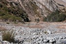
Nearby
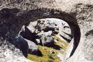
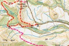
Cave Stream
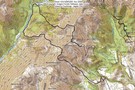
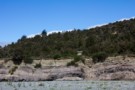
Castle Hill
Photograph
•
Distance: 1.5km away
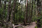
not much of a tramp, but worth a look. Flock hill.
More ▶︎
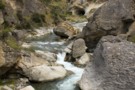
Broken River Hut via Cave Stream
GPX file
•
Distance: 1.7km away
Alternative route to Broken River Hut. Land owners' permission needed.
More ▶︎
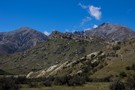
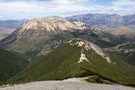
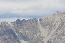
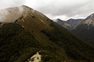
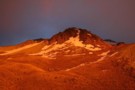
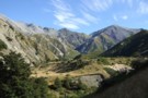
Prebble Hill (902m)
Photograph
•
Distance: 2.4km away
Red Peak (1853m), The Gap, and Castle Hill Peak (1998m) behind.
More ▶︎
Hog's Back Track
Track
•
Easy. Return by the same track.
•
Distance: 3.0km away
https://www.craigieburntrails.org.nz/tracks/hogs-back-track/
More ▶︎
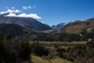
Hogs Back Circuit
Track
•
Easy. Loop track.
•
Distance: 3.5km away
Great views of the Cass basin and surrounding mountain ranges.
More ▶︎
Hogs Back Circuit
Photograph
•
Distance: 3.5km away
A variation of the Hogsback mountain bike track. The mtb track is roughly marked as s-d-c-t. The walking circuit is ...
More ▶︎
Craigieburn Shelter campsite
Campsite
•
Basic Campsite (DOC). 20 spaces.
•
Distance: 3.5km away
Popular campsite on the banks of Cave Stream in Craigieburn Forest Park, with a number of easy walking tracks nearby. ...
More ▶︎
Helicopter Hill Circuit
Track
•
Easy/medium. Loop track.
•
Distance: 3.6km away
This circuit in Craigieburn Forest Park knits together several different tracks, and visits the summit of Helicopter Hill (1256m).
More ▶︎
Camp Saddle / Lyndon Saddle circuit
GPX file
•
Distance: 4.1km away
A loop in Craigieburn Forest Park, leading up onto a spur of the Craigieburn Range.
This route leads up the Broken ...
More ▶︎
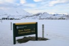
DOC sign
Photograph
•
Distance: 4.2km away
Kura Tawhiti Conservation Area is the karst landscape also known as Castle Hill, located on the road between Porter's and ...
More ▶︎
View of Torlesse Gap from the west
Photograph
•
Distance: 4.6km away
The well recognised landmark on the Torlesse Range can easily be seen from the top of Broken Hill in the ...
More ▶︎
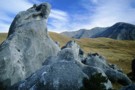
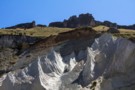
Striking limestone formations of Castle Hill
Photograph
•
Distance: 4.7km away
Known as Kura Tawhiti to Ngāi Tahu, this is an area of historic significance, with rock drawings hidden amongst the ...
More ▶︎
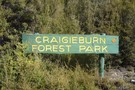
Craigieburn Forest Park
Place
•
Conservation Park. 441.65km2.
•
Distance: 4.7km away
A small park south of Arthur's Pass National Park including a series of ski fields. Highest point: 2141m (Mt Avoca).
More ▶︎
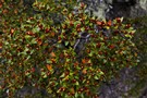
Beech flowers
Photograph
•
Distance: 4.8km away
Bright red mountain beech flowers on Helicopter Hill, Craigieburn Forest.
More ▶︎
Helicopter Hill
Photograph
•
Distance: 5.0km away
From Lyndon Saddle, the climb to the small summit is quick and easy (1256m).
More ▶︎
Mount Wall
GPX file
•
Distance: 5.2km away
A circuit from the Broken River locked gate up onto the Craigieburn Range, along to Mount Wall, and down. Points ...
More ▶︎
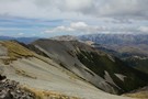
Camp Saddle / Lyndon Saddle spur
Photograph
•
Distance: 5.6km away
Scree slope leading down to Lyndon Saddle and Helicopter Hill. Over the highway is the yellow Broken Hill, with the ...
More ▶︎
Camp Saddle / Lyndon Saddle spur
Photograph
•
Distance: 6.6km away
Once up on Camp Saddle, it's a straightforward ridge cruise following the arc to the left.
More ▶︎
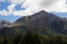
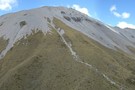
Mount Wall
Photograph
•
Distance: 6.6km away
1874m peak on the Craigieburn Range. The Broken River Ski Club occupies the valley to the right.
More ▶︎
Mount Wall, Craigieburn Range
Track
•
1 day. Medium/hard. Return by the same track.
•
Distance: 6.6km away
Day walk to a summit overlooking the Broken River Ski Area.
More ▶︎
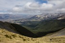
Camp Saddle
Photograph
•
Distance: 6.7km away
The view south, down Camp Stream, Craigieburn Range.
More ▶︎
Complete and Final Version of Craigieburn Double Crossing
Article
•
Distance: 6.8km away
Double crossing of the Craigieburn Range from Hogs Back MTB trail over to Hamilton Hut, then return via Mt Cheeseman ...
More ▶︎
Double Crossing of Craigieburn Range
Photograph
•
Distance: 6.8km away
Queens Birthday weekend trip, combined with scenic tour down the Harper to Mystery Tarn, on the Clay Range.
More ▶︎
Mt Plenty, Ghost Creek Circuit
Article
•
Distance: 8.4km away
A day trip involving a 700 m climb then descending a creek with 2 challenging sidles past waterfalls.
More ▶︎
Near Broken River Hut
Photograph
•
Distance: 8.6km away
The view up Winding Creek to Purple Hill from one of the terraces above the hut.
More ▶︎
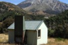
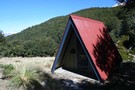
Broken River Hut
Hut
•
Basic Hut/Bivvy (DOC). Capacity: 4.
•
Distance: 8.6km away
Located upstream of Avoca Homestead.
More ▶︎
Broken River hut Feb 2012
Photograph
•
Distance: 8.6km away
This 1960 vintage NZFS 4 bunker is about 1.5hrs upstream from the Avoca Homestead hut. There are various coal mining ...
More ▶︎
Broken River Hut
Photograph
•
Distance: 8.6km away
This little hut sits on a sunny terrace and a coal seam. The layers exposed here are part of the ...
More ▶︎
Torlesse Range Feb 2014
Photograph
•
Distance: 8.7km away
This photo is taken from slightly uphill of & beside the John Hayward Memorial Hut (Kowai Hut) in the Kowai ...
More ▶︎
Kowai/Castle Hill Peak/Porters Pass Circuit
Article
•
Distance: 8.9km away
Circuit of the above. Can be done as a day trip or in our case, 2 days broken by a ...
More ▶︎
Castle Hill Peak
GPX file
•
Distance: 9.0km away
Straightforward alpine walk with great views.
More ▶︎
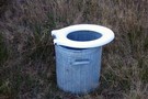
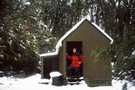
Bush toilet
Photograph
•
Distance: 9.4km away
I found this toilet when I was camping at the start of the Cass saddle track and thought it would ...
More ▶︎
Cass Saddle
Photograph
•
Distance: 9.4km away
Looking across the Cass Saddle from ridge on North Side.
More ▶︎
Cass-Lagoon Saddle
Track
•
2 days. Medium. One way.
•
Distance: 9.4km away
This classic route from Cass to Cora Lynn Road circles the Black Range to form an open loop, and a ...
More ▶︎
Cass Saddle
Track
•
1 day. Easy/medium. One way.
•
Distance: 9.4km away
From the car park at the east end of the Cass road bridge, follow the vehicle track next to the ...
More ▶︎
Mt Enys - Finally!
Article
•
Distance: 9.6km away
An account of our 4 attempts to climb Mt Enys directly via Deadman Spur.
More ▶︎