Nearby
Hopkins Valley
Huxley Valley
Track
•
2 days. Easy/medium. Return via same track.
•
Distance: less than 100m away
Easy walking at the head of Lake Ohau.
More ▶︎
Hopkins Valley
Track
•
3 – 4 days. Easy/medium. Return via same track.
•
Distance: less than 100m away
A very long, straightforward valley at the head of Lake Ohau.
More ▶︎
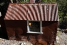
Monument Hut
Hut
•
Standard Hut (DOC). Capacity: 6.
•
Distance: less than 100m away
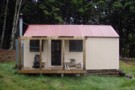
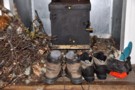
Monument Hut (6 bunks, matresses, stove, firewood, river water) is a forestry style hut in the Hopkins. Its located just ...
More ▶︎
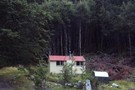
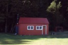
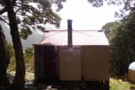
Monument Hut
Photograph
•
Distance: less than 100m away
Monument Hut, in the Hopkins - a handy evening walk in for those heading up the Hopkins or Huxley the ...
More ▶︎
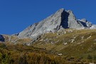
Dasler Pinnacles
Photograph
•
Distance: less than 100m away
Dasler Pinnacles (2315m) from track through scrub above Dasler Biv.
More ▶︎
Dasler Pinnacles
Track
•
2 days. Medium/hard. Return via same track.
•
Distance: less than 100m away
This trail leads from the flat valley floor steeply up to Dasler Biv and beyond the the Pinnacles themselves.
More ▶︎
Picton to Aspiring
GPX file
•
Distance: 101m away
An aborted alpine traverse. Picton to West Cape, but aborted at Aspiring due to real world emergencies back home. Posted ...
More ▶︎
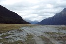
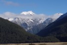
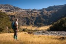
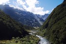
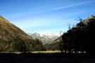
Huxley Valley
Photograph
•
Distance: 2.7km away
Huxley Valley, looking towards the Forks. Forks Hut is on flats at the base of the peak in the distance.
More ▶︎
Red Hut
Hut
•
Standard Hut (DOC). Capacity: 12.
•
Distance: 3.3km away
Historic hut in the Hopkins Valley north of Lake Ohau. Constructed in 1916 for commercial tourism, and recently restored.
More ▶︎
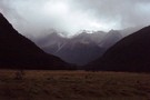
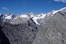
Huxley Valley, Anita Peak from Red Hut
Photograph
•
Distance: 3.3km away
Huxley Valley, Anita Peak from Red Hut in the Hopkins
More ▶︎
Ruataniwha Conservation Park
Place
•
Conservation Park. 368.00km2.
•
Distance: 3.3km away
The Ruataniwha Conservation Park occupies a mountainous landscape, and includes the valleys of the Dobson, Hopkins, Huxley, Temple and Maitland ...
More ▶︎
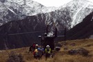
Otago rescue chopper, Huxley Valley
Photograph
•
Distance: 4.7km away
The Otago rescue chopper up the Huxley, called using an EPIRB (beacon) upon finding a party with an injured member ...
More ▶︎
Huxley Forks Hut
Hut
•
Standard Hut (DOC). Capacity: 6.
•
Distance: 5.6km away
Huxley Forks Hut (6-bunk, matresses, stove, firewood, tank/creek water) is an old, homely forestry-style hut at the forks of the ...
More ▶︎
Gunsight Pass
Article
•
Distance: 5.8km away
With a couple of spare days in South Canterbury the forecast gale nor'westerlies and heavy rain on the main divide ...
More ▶︎
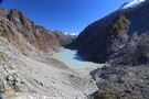
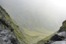
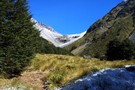
Temple Stream North Branch
Photograph
•
Distance: 5.8km away
View of the spectacular cirque at the end of Temple Stream North Branch.
More ▶︎
Mad Pom's latest adventure. Part 2
Article
•
Distance: 5.9km away
A trip to the head on the landsborough, and all that ensues. Part two.
More ▶︎
Mad Pom's latest adventure
Article
•
Distance: 5.9km away
A trip to the heads of the Landsborough ... and all that ensues.
More ▶︎
Mad Pom's latest Adventure - Part 5
Article
•
Distance: 5.9km away
A trip to the head of the Landsborough - and all that ensues.
Part 5 - Heroes and Angels.
More ▶︎
Mad Pom's latest Adventure - part 4
Article
•
Distance: 5.9km away
A trip to the head of the Landsborough - and all that ensues.
Part 4: the longest walk.
More ▶︎
Temple Stream - North Branch
Track
•
1 day. Easy/medium. Return by the same track.
•
Distance: 5.9km away
North Temple Track.
Cross North Temple Stream and follow the track up North Temple valley. The track has been washed out ...
More ▶︎
South Huxley Bivvy
Hut
•
Basic Hut/Bivvy (DOC). Capacity: 2.
•
Distance: 6.2km away
Small hut on the Huxley River South Branch.
More ▶︎
Halfway up to Gunsight Pass
Photograph
•
Distance: 7.0km away
Climbing up the gut from Temple Stream North Branch to Gunsight Pass. Looking back to the cirque at the head ...
More ▶︎
Hopkins/Dobson confluence
Photograph
•
Distance: 7.7km away
Hopkins and Dobson Valley, from Huxley Lodge. Note that Huxley Lodge (at the roadend) is a private school lodge. The ...
More ▶︎
Dasler Bivouac
Photograph
•
Distance: 7.9km away
Small hut just below bushline on track to Dasler Pinnacles.
More ▶︎
Dasler Bivouac
Hut
•
Basic Hut/Bivvy (DOC). Capacity: 2.
•
Distance: 7.9km away
Historic tin biv constructed in 1966 and located on the steep wall of the Hopkins Valley near the Dasler Pinnacles. ...
More ▶︎
Huxley North Branch
Photograph
•
Distance: 8.5km away
The North Branch of the Huxley towards Brodrick Hut and Mt Strauchon
More ▶︎
Brodrick Hut
Hut
•
Standard Hut (DOC). Capacity: 6.
•
Distance: 8.9km away
Brodrick Hut (sleeps 6, tank water, stove, firewood available) is a 1960's forestry hut at the base of the Brodrick ...
More ▶︎
Le Crens Hut / L. A. Crens Hut
Hut
•
Private hut (PVT). Capacity: 4.
•
Distance: 9.0km away
L.A. Crens Hut (private?, 4 bunk, fireplace, stream water) is a historic station hut on Glen Lyon Station land in ...
More ▶︎
Temple View
Track
•
Easy/medium. Return via same track.
•
Distance: 9.2km away
The Temple Valley is headed by a ring of handsome mountains. This walk explores the lower section of the valley, ...
More ▶︎
South Temple Hut
Track
•
1 – 2 days. Easy/medium. Return by the same track.
•
Distance: 9.2km away
Beech forest walk at the head of Lake Ohau. This Track is best done as an overnight walk with a ...
More ▶︎
A Temple - Maitland Circuit: the perils and joys of tramping in company
Article
•
Distance: 9.3km away
or ... 'He took me tramping and I cried'
Taking others tramping is for me, always an exercise fraught with doubt. ...
More ▶︎
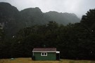
Temple Shelter
Hut
•
Shelter (DOC).
•
Distance: 9.3km away
Temple Shelter is a three-and-a-half walled shelter at the DOC campground at the Temple Stream roadend. The shelter has a ...
More ▶︎
Temple Valleys Circuit
Track
•
2 – 3 days. Medium. Loop track.
•
Distance: 9.4km away
Tramping the North and South Temple Valleys connecting the two over Gunsight Pass.
More ▶︎
South Temple
Photograph
•
Distance: 9.7km away
The South Temple valley, looking towards the forks 2km below Sth Temple Hut (hut is up the main valley to ...
More ▶︎