Friday night
There are a couple of cars at the Temple roadend – the intentions book lists one group of six headed into the Sth Temple
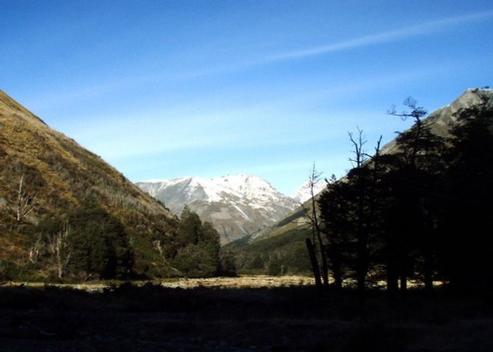
The trip up the Temple
The rivers are low, and crossing of the North Temple is achieved with dry feet intact. We continue up the gravel flats, myself muttering about ‘not remembering it being like this’. The day is clear – sunshine and blue skies – but a bitter strong nor-wester stirring dust storms down the length of the Hopkins Temple
The source of the devastation is revealed after 3km – the gravel fan draining a major basin on the true left is enlarged beyond recognition – the shingle and rock bluffs on its downstream side undercut, fallen away. From the devastation the best guess is that a landslide has temporarily dammed the creek: the energy and debris later all released in a huge flow as the dam broke.
Upriver the nature of the Sth Temple
The track sidles low on the northern valleyside, sometimes meandering through rocks and scrub on the river flats, sometimes climbing to low terraces in the open beech forest, sometimes crossing scree fans on the well shelved platforms I recall from previous visits. We pass the side-valley leading to the Maitland, an easy pass – allegedly the fastest route into the Maitland. A couple of km beyond, the Temple splits into first 2, then 3 major valleys – all leading to passes into the Ahuriri, and the southern also to the Maitland. On tussock terraces 50m from the river, the Sth Temple Hut welcomes us on the far bank. The swingbridge long gone – the crossing a guarantee of wet feet tonight and damp boots for the morning.
The hut is much as I remember it: a woodburner at one end, sleeping platforms at the other – the lower sleeping 4 and the upper just 2 – luck the previous party did leave or it’d have been tent for us. Sandflies abound, inside and out. A few mass culls ensue, but the little black bighters continue to appear. Diligent observation reveals their points of entry – the grooves in which the aluminium windows slide. 6 socks later we have the place flyproof, and settle in for a comfortable night. The radio forecasts rain overnight, clearing by morning. Sound’s good.
We wake a few times in the night to the sound of rain on the roof. Morning comes and the sound of water’s still there – louder than ever. What happened to ‘clearing by morning’? A head outside, and the source of the noise is clear. The rain has stopped, but the main flow of the Sth Temple
Saturday
We leave the hut at an almost respectable time in the morning, heading through wet beech forest up the true left of the south branch of the Temple
We continue through mature beech forest on the true tight of the creek, on the mossy valley floor, up old, dry river channels. The route is reasonable well traveled, but marked only by almost disintegrated blue feratox bags, which I recall from my last trip 4 years before. We need to cross again to the TL and climb, a little before the next gorged section where a waterfall cascades from the right-hand bank. Eying every ridge we pass I realize I can’t recall which one it was I climbed.
Scoping out possible routes, doubling back when wrong, is second nature when alone – but feels very self conscious in company: I’m well aware I’m liable, when with others, to stick to the wrong route long after doubt would have caused me to stop and consider others if I were alone. Remind myself of the dog in ‘track’ mode: realising she’s no longer confident of the line she’s following, but too afraid to admit it, slinking along tail between legs ahead of me instead of admitting to her confusion.
Thankfully a large X of permolat on a prominent tree just before the gorge clearly marks the ascent to take – up a steep ridge on the TL, climbing well above the gorge before sidling flat across steep slopes of first loose beech litter, later mossy scree, to meet the river again 1km upstream.
The bushedge is not far beyond. Following the creek, now small enough to cross at will, we emerge into the first tussock clearing. Beech continues to our left, following a small gully parallel to the main valley a further kilometer before also giving way to golden tussock. Ahead to the east a valley rises steeply towards the divide with the Ahuriri, scree, hints of snow at it’s summit. But the main Temple
A bitter north-west wind whips up the valley – chasing us and making lunch a brief, crouched affair. The creek, still significant, flows through a deeply notched rocky channel, becomes dry, water running hidden beneath stone. Later reappears: small, gurgling, twisting between the tussocks.
We climb higher, up the gravel and tussock slopes of the first step - the view getting more expansive as we rise. Black clouds sweep squalls of rain down the North Temple , bringing with them the cold of the snow-covered main divide beyond. The second step is harder: choice of climbing a steady slope of free running scree to our left, or a more stable but steeper rocky river
The final climb up bare but stable boulder-scree to reach the lakes, a stroll under blue skies and sunshine on my last visit, is a hunched slog under a bitter wind. Rain squalls turn to fine needles of ice and snow. We scuttle over the ridge into the relative shelter of the tarns’ basin beyond. The striking scene I recall: the reds of the rock against the blue and green of the tarns have all turned to steel under grey skies. Patches of snow accumulate in sheltered spots, but most remain bare – the wind too strong to allow anything to settle.
Sim looks tired, cold, and not amused. ‘Not much fun when it’s like this’, I comment. She agrees.
The last of the climb is a brief scramble up loose scree to the ridgeline east of Mt Maitland, directly behind the tarns. I top the ridge and drop relieved into the still, warmer air beyond. Look happily down at the ‘scree elevator’ which will drop me 600m towards the valley floor in 10-15 minutes. Sim, on the other hand, stares in despair. Despite her many stories of climbing overseas, scree-running clearly does not feature on her list of experiences.
She’ll get it soon enough.
I set off down, surfing beautifully on the free-running rock. Lean back, each leisurely step dropping 1, 2 meters down the face. I’m soon 100m down with no effort expended, look back to see how Sim is going. Tramping poles braced against the descent, she’s stepping carefully down the slope, meters from where we started. I wait several minutes as she picks her way down to where I stand. I explain the principles of scree running: going with the flow, keeping weight back so that if you do start to lose balance you can simply sit down and stop. To give her credit, she tries – but never manages the confidence to lean back, set up a wave and follow it. Her weight forward, braced against the tramping poles, reliant entirely on them in case of a fall, all it will take is one pole to be misplaced for her to tumble head-first down the slope. I’m almost relieved when she finally gives in and starts back-climbing down the slope. It’s an hour and a half later before we stand at the foot of the face.
Sim starts to cry.
She tells me how she’s never going tramping with me again, never crossing another mountain pass, never following a so-called ‘route’, never leaving home unless the weather’s perfect.
Even the dog looks worried.
What I really want to say is ‘yes – that’s all really nice. But what you need to do right now is stop crying, start walking, and get us off this bloody mountain before it gets dark.’ Instead, I offer comfort and encouragement, which only results in more tears. The dog however has had enough by this stage, and jumps up, giving her a good shove in the right direction to my silent cheers. Tears turn to laughter at this non-too subtle hint, and we set off down to the bushline 300m below with promises to find a sheltered spot for tea and camp - I'd merntally abandoned plans to reach Maitland Hut several hundred meters above - just hadn't had the heart to break the news.
Below the initial scree face, the unnamed creek flows through a broad gully tussock flanked on both sides by beech forest. We stop under the first good shelter tree, and Sim brews up some noodles whilst I scout for a spot to camp. By the time we both have the energy and warmth of noodles and tea inside us, neither are too keen to stop, so we push on towards more obvious camping spots on the flats at the confluence with the Maitland.
An old track, presumably from deer-culling days, follows the valley down, marked occasionally with tin lids and cut blazes. Unfortunately the deer-culler in question was probably the last person to cut it. Windfall frequently blocks the route, undergrowth scratches at legs and tangles with boots and ankles. Going is slow and we frequently end up making our own route. The valley drops steeply, the creek sometimes gorged, sometimes open, the ‘track’ crossing the creek numerous times. Another large valley joins from the east: the more usual low-level crossing from the Temple
There are great camp spots on the large flat where the gully meets the Maitland, fire rings to show their use. Unfortunately we chicken out and pitched tent 1km further upriver on a somewhat sloping spot. It provides, however, a dry and soft bed of leaf litter, and a great night’s sleep.
Sunday
From the Maitland confluence downstream there are two options: climb the face opposite and locate the sidle track which climbs some 400m before joining a farm track sloping steadily down the face to Maitland Station, or follow the river.
The valley passes through a series of narrow flats and narrower gorges. Crossings are generally knee to waist deep in normal flows. I try out 2-person river crossings for the first time – never having had the opportunity before. I’m impressed by the stability the second person offers, allowing a steady crossing at a slow pace. I find, however, that the technique of trotting diagonally downriver using the current and relying on flotation to keep upright, which has served me so well alone, does not seem to work with two. I wonder whether crossing alone might be easier in the strongest, deepest flows – allowing you the freedom to work with, rather than against the water.
All in all we make some 20+ crossings descending the river. Flats finally open up on the TR, offering an easier route though possibly through private land. Sim, however, is enjoying the river too much, and we continue our way in the water and on the banks to the road bridge.
A super shed provides shelter at the road-end whilst I drop packs and jog back to the Temple
An hour after reaching the bridge we’re sat by the fire at the Lake Ohau Lodge, eating cake and supping hot chocolate, dreaming of future trips. I suggest some well-tracked valley walks: Hollyford, Rees-Dart. Sim dismisses them scornfully: too easy, boring. Starts scouring the maps for routes over alpine passes that strike her as having the potential for adventure.