Nearby
West Mathias Bivvy
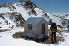
Centennial Cabin
Hut
•
Basic Hut/Bivvy (PVT). Capacity: 3.
•
Distance: 3.3km away
Private hut on the West Mathias River, Rakaia Forest Conservation Area.
More ▶︎
Mathias Hut
Hut
•
Basic Hut/Bivvy (NZDA). Capacity: 6.
•
Distance: 4.1km away
NZDA hut on the Mathias River.
More ▶︎
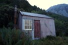
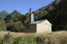
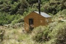
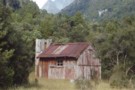
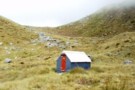
Moraine Hut
Photograph
•
Distance: 4.5km away
Moraine Hut, Mathias valley. Owned by Mt Algidus - for over 100 years
More ▶︎
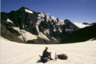
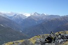
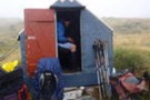
Observation Col
Photograph
•
Distance: 5.4km away
Technically easy, but does require crampons and axe. Approached from South Mathias Biv, bivvied under Col, went down Cattle Stream ...
More ▶︎
Mt Misery & beyond February 2013
Photograph
•
Distance: 6.2km away
Last month I decided to climb a hill that can be seen from home that I'd never got around to ...
More ▶︎
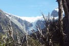
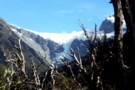
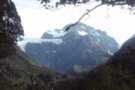
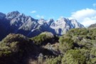
Bracken Snowfield / Wilkinson Glacier
Photograph
•
Distance: 8.0km away
Bracken Snowfield / Wilkinson Glacier, from the Prices Flat - Wilkinson Hut track. In the Whitcombe River valley, Westland.
More ▶︎
Whitcombe Pass
Track
•
5 – 7 days. Medium/hard. One way.
•
Distance: 8.2km away
This route follows the famous journey by John Henry Whitcombe and the Swiss guide Jakob Lauper across the Main Divide ...
More ▶︎
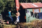
Wilkinson hut 1993
Photograph
•
Distance: 8.2km away
This pic shows track cutters Kelvin and Merv outside Wilkinson hut in 1993. This photo was taken by mate JH.
More ▶︎
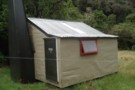
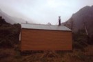
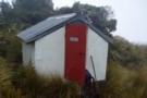
Wilkinson hut
Hut
•
Basic Hut/Bivvy (DOC). Capacity: 4.
•
Distance: 8.2km away
A 1950's era NZFS cullers hut on the TL of the Whitcombe River just over a km downstream from where ...
More ▶︎
Wilkinson hut April 2012
Photograph
•
Distance: 8.2km away
This pic was taken last month when travelling from Prices Basin to Prices Flat. I needed to head up to ...
More ▶︎
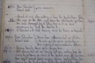
Wilkinson hut reference / Nostalgia / History
Photograph
•
Distance: 8.2km away
I came across these hut book entries when searching the archived Frews hut book looking for info to support my ...
More ▶︎
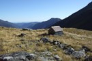
Canyon Creek Biv
Photograph
•
Distance: 8.4km away
Canyon Creek Biv, upper Mathias valley. Sleeps 2. Note: the biv's location is incorrectly marked on NZ topomaps (2012). The ...
More ▶︎
Cave Camp
Rock bivouac
•
Distance: 8.5km away
Located on the Whitcombe Track, on river flats just beneath the confluence with the Wilkinson River. The biv affords a ...
More ▶︎
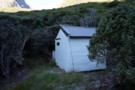
Canyon Creek Biv
Hut
•
Basic Hut/Bivvy (DOC). Capacity: 2.
•
Distance: 8.6km away
Iron hut on scrubflats in the North Mathias River.
More ▶︎
Whitcombe Pass & Butler Saddle
Article
•
Distance: 8.8km away
route guide attached by for Hokitika Gorge to Erewhon via Whitcombe Pass & Butler Saddle. The guide was written by ...
More ▶︎
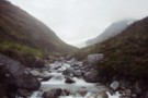
Wilkinson Glaciers
Photograph
•
Distance: 8.8km away
Glaciers descend from the Bracken Snowfield accross the valley from the track from Prices Flat to Neave Hut in the ...
More ▶︎
Picton to Aspiring
GPX file
•
Distance: 8.8km away
An aborted alpine traverse. Picton to West Cape, but aborted at Aspiring due to real world emergencies back home. Posted ...
More ▶︎
Neave Hut
Photograph
•
Distance: 8.9km away
Neave Hut, in the upper Whitcombe, Westland. The hut lies just 5km below the Whitcombe Pass intot he Raikaia.
More ▶︎
Neave Hut
Hut
•
Standard Hut (DOC). Capacity: 6.
•
Distance: 8.9km away
Neave Hut (6 bunks, matresses, stream water, stove, limited firewood) is a comfortable forestry-style hut in the upper Whitcombe Valley, ...
More ▶︎

Route Guide: Otira to Mt Cook Village (pt 2)
Track
•
12 – 21 days. Hard. One way.
•
Distance: 8.9km away
One possible route down the main divide from Otira on the Arthur's Pass road to Mt Cook Village.
Otira Hotel ...
More ▶︎

Route Guide: Otira to Mt Cook Village (pt 1)
Track
•
12 – 21 days. Hard. One way.
•
Distance: 8.9km away
One possible route down the main divide from Otira on the Arthur's Pass road to Mt Cook Village.
Otira Hotel to ...
More ▶︎
Mount Evans
Photograph
•
Distance: 8.9km away
Mt Evans, from Neave Hut in the upper Whitcombe Valley of Westland.
More ▶︎
Upper Whitcombe River at Neave Hut
Photograph
•
Distance: 8.9km away
The upper Whitcombe River at Neave Hut, just 5km from its headwaters at the Whitcombe Pass. The track to the ...
More ▶︎
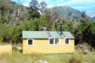
Prices Flat Hut
Photograph
•
Distance: 9.2km away
The new(er) Prices Flat Hut, in the Whitcombe Valley, Westland.
More ▶︎
Price Flat Hut
Hut
•
Standard Hut (DOC). Capacity: 6.
•
Distance: 9.2km away
Prices Flat Hut (6 bunks, matresses, tank water, stove) lies on a small terrace 100m above the Whitcombe River, adjacent ...
More ▶︎
Prices Flat Hut (historic)
Photograph
•
Distance: 9.4km away
Prices Flat Hut (historic) - in the Whitcombe Valley, Westland. A place full of character, and full of sandflies. A ...
More ▶︎
Prices Flat Hut (historic)
Hut
•
Basic Hut/Bivvy (DOC). Capacity: 4.
•
Distance: 9.4km away
The historic Prices Flat Hut is better looked at than slept in. It is a beutiful slab hut, with an ...
More ▶︎
Historic Price Flat Hut
Hut
•
Basic Hut/Bivvy (DOC). Capacity: 4.
•
Distance: 9.5km away
Slab hut once used for deer culling and possibly dating to 1908. The hut is located next to the newer ...
More ▶︎
Frews Biv
Photograph
•
Distance: 9.8km away
little (officially anyway) two man job on Frews Saddle
More ▶︎
Looking NW over Frew biv April 2011
Photograph
•
Distance: 9.9km away
This pic looks over top of the biv down Frew Creek to the Whitcombe and on out to the coast. ...
More ▶︎
Frew Saddle Bivouac
Photograph
•
Distance: 9.9km away
Frew Saddle Bivouac, between the Whitcombe and Hokitika valleys in Westland.
More ▶︎
Frew Saddle Bivouac / Frew's Biv
Hut
•
Basic Hut/Bivvy (DOC). Capacity: 2.
•
Distance: 9.9km away
The Frew Saddle Bivouac (sleeps 2, matresses, stream water 100m distant, no fire) is a well maintained alpine bivouac 200m ...
More ▶︎
Whitcombe/Frews Saddle/Bluff Hut/Homeward Spur/Toaroha Saddle/Crystal Biv/Cedar Flats
Article
•
Distance: 9.9km away
a five day circuit
More ▶︎
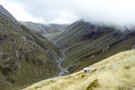
Upper Hokitika River from Frew Saddle
Photograph
•
Distance: 9.9km away
Tussock hides the ubiquitous speargrass in the upper reaches of the Hokitika, giving the illusion of an easy, pleasant tramp.
More ▶︎
Toaroaha Saddle-Frew Saddle Circuit
Track
•
4 – 6 days. Medium. One way.
•
Distance: 9.9km away
A great tramp in a remote location, crosses two alpine saddles, ice-axes and crampons needed in winter. More information on ...
More ▶︎