Nearby
Sleepy Hollow
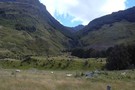
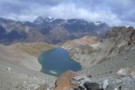
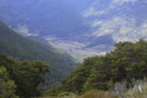
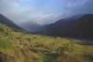
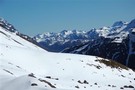
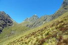
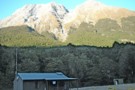
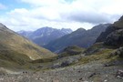
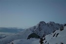
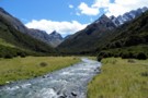
Gorge Creek / Dart Valley
Photograph
•
Distance: 118m away
Gorge Creek and the Dart Valley, from the Sleepy Hollow pass between the Caples and Dart valleys.
More ▶︎
Sleepy Hollow Pass route (Caples to Dart)
Track
•
Medium/hard. One way.
•
Distance: 118m away
The Sleepy Hollow pass route from the mid-Caples to the Dart Valley. This can be combined with either a walk ...
More ▶︎
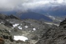
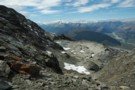
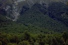
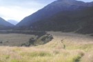
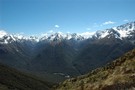
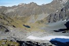
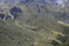
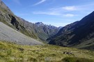
Sleepy Hollow
Photograph
•
Distance: 118m away
Sleepy Hollow above the mid Caples Valley. The pass to Gorge Creek / Glacier Burn and the Dart Valley is ...
More ▶︎
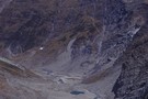
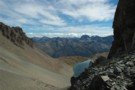
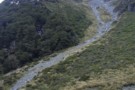
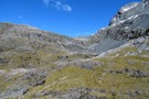
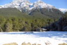
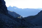
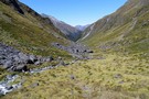
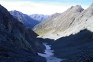
Sleepy Hollow
Photograph
•
Distance: 118m away
Sleepy Hollow from the top of the pass into the Dart.
More ▶︎
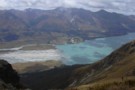
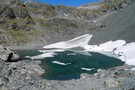
Sleepy Hollow
Photograph
•
Distance: 700m away
From near Bold Peak. Inspired by madpom, I went the opposite direction via Glacier Burn to Kay Creek
More ▶︎
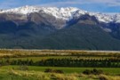
Mid Caples Valley
Photograph
•
Distance: 2.0km away
Mid Caples Valley from pt1168, just above the bushedge the way to Sleepy Hollow. Mid Caples Hut is just visible ...
More ▶︎
Glacier burn - ascent to sleepy hollow pass
Photograph
•
Distance: 3.2km away
From Glacier Burn to Sleepy Hollow pass: route leaves the Glacier Burn track and climbs this scree gully on the ...
More ▶︎

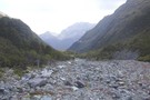
Descent to Glacier Burn
Photograph
•
Distance: 3.2km away
The final descent to Glacier Burn from pt1731, on the route from the Caples valley via Sleepy Hollow.
More ▶︎
Caples Track
Track
•
2 days. Easy/medium. One way.
•
Distance: 4.5km away
A quiet track climbing alongside the Caples River through forest and grassy flats and over a sub-alpine saddle.
More ▶︎
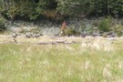
Caples Valley Fallow Deer
Photograph
•
Distance: 4.5km away
Spooked a mob of 30+ deer back in 06/07.
More ▶︎
Mid Caples Hut
Hut
•
Serviced Hut (DOC). Capacity: 24.
•
Distance: 5.2km away
A new $535000 hut opened February 2014, to replace the smaller hut on the site.
The hut provides pleasant views over ...
More ▶︎
Scott Saddle route (Dart to Caples)
Track
•
1 – 2 days. Medium. One way.
•
Distance: 5.2km away
This route crosses the easiest pass from the Dart to Caples Valleys, via Scott Creek, Scott Saddle and Kay Creek ...
More ▶︎
Key Summit
Photograph
•
Distance: 5.4km away
Key Summit from the Humboldts, looking towards the Earl Mountains. Kay Creek in the foreground
More ▶︎
Key Summit
Photograph
•
Distance: 5.4km away
Key Summit from the Humboldts, looking towards the Earl Mountains. Kay Creek in the foreground
More ▶︎
Greenstone / Caples Tracks
Track
•
4 days. Easy/medium. Loop track.
•
Distance: 5.4km away
The Greenstone and Caples Tracks are often linked together to form a circuit from the shores of Lake Wakatipu. Long ...
More ▶︎
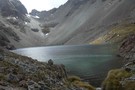
Kay Creek Hut
Photograph
•
Distance: 5.9km away
Kay Creek Hut, between the Caples and Dart valleys.
More ▶︎
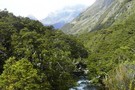
Fraser Creek & Kay Creek
Photograph
•
Distance: 6.2km away
View from route to Steele Creek from the Upper Caples hut
More ▶︎
Fraser Creek
Track
•
1 – 2 days. Easy/medium. One way.
•
Distance: 6.4km away
One of several valleys that cut into the southern Humboldt Mountains. It passes through many kilometres of beech forest, river ...
More ▶︎
Paradise Road Glenorchy, New Zealand, Fiordland, April 2018
Photograph
•
Distance: 6.4km away
Paradise Road Glenorchy, New Zealand, Fiordland, April 2018
More ▶︎
Kay Creek
Photograph
•
Distance: 6.5km away
Kay Creek, looking downstream from Kay Creek Hut
More ▶︎
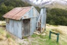
Kay Creek Hut
Hut
•
Basic Hut/Bivvy (DOC). Capacity: 3.
•
Distance: 6.5km away
Kay Creek Hut (sleeps 3-4, fireplace, firewood available, creek water) makes up for in character what it lacks in comfort. ...
More ▶︎
Kay Creek - Upper Caples
Photograph
•
Distance: 6.8km away
April 2006 - Taken while coming back down Kay Creek to the Upper Caples DOC hut
More ▶︎
Upper Caples Hut
Hut
•
Club hut (Southern Lakes Deerstalkers Association). Capacity: 16.Bookings required.
•
Distance: 7.5km away
Comfortable hut in the Upper Caples Valley.
This hut was closed to the public in February 2014, but is now reopened ...
More ▶︎
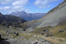
Dart Valley from Kay Saddle
Photograph
•
Distance: 7.6km away
Looking back down through Scott Basin to the Dart from Kay saddle
More ▶︎
Glenorchy Lagoon
Track
•
Easy. Loop track.
•
Distance: 7.7km away
Stroll along boardwalks through this lagoon occupying an old bend of the Rees River. The lagoon is dominated by willows, ...
More ▶︎
Home Hill Hut
Hut
•
Basic Hut/Bivvy (DOC). Capacity: 2.
•
Distance: 7.7km away
A rustic hut above the old Birchdale Homestead site in the Caples Valley.. Roof has been replaced and new bunks ...
More ▶︎
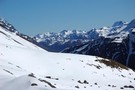
Scott Saddle
Photograph
•
Distance: 7.9km away
Scott Saddle (1450m) between Scott Creek and Kay Creek. This is the easiest pass between the Dart and Caples valleys. ...
More ▶︎
Scott Saddle
Photograph
•
Distance: 8.0km away
Scott Saddle (1450m) between Scott Creek and Kay Creek. This is the easiest pass between the Dart and Caples valleys. ...
More ▶︎
Death Valley Saddle
Photograph
•
Distance: 8.0km away
Death Valley is an offshoot of Kay Creek and makes an interesting and straight forward alternative to a crossing from ...
More ▶︎
Not The Routeburn
GPX file
•
Distance: 8.1km away
A six-passes, seven catchments trip through the Humboldt Mountains from Glenorchy to The Divide.
Note that for access from Double Barrel ...
More ▶︎
Death Valley
Photograph
•
Distance: 8.1km away
Death Valley is an offshoot of Kay Creek and makes an interesting and straight forward alternative to a crossing from ...
More ▶︎
Death Valley from Saddle
Photograph
•
Distance: 8.1km away
Death Valley is an offshoot of Kay Creek and makes an interesting and straight forward alternative to a crossing from ...
More ▶︎
Kay Lake and Death Valley Saddle
Photograph
•
Distance: 8.2km away
Death Valley is an offshoot of Kay Creek and makes an interesting and straight forward alternative to a crossing from ...
More ▶︎

Haast to The Divide
GPX file
•
Distance: 8.6km away
Andrew Barker's traverse 2009. From Pleasant Flat in the Haast to The Divide via Mt Aspiring National Park.
More ▶︎
Heather Jock Hut
Track
•
1 – 2 days. Easy. Loop track.
•
Distance: 9.0km away
A gentle climb through a mining area to a small hut with panoramic mountain views.
More ▶︎
Scott Basin
Photograph
•
Distance: 9.2km away
Scott Basin at the head of Scott Creek, between the Dart and Caples valleys. Scott Creek Hut (dilapidated) is located ...
More ▶︎
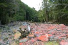
Death Valley glacier (rems.)
Photograph
•
Distance: 9.4km away
Death of a glacier.
Death Valley, Humboldt Mountains
More ▶︎
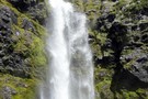
Fraser Creek Waterfall
Photograph
•
Distance: 9.6km away
Unnamed waterfall crashing out of a hanging valley about half way up the Fraser. Its well worth the 15-20 minute ...
More ▶︎
Scott Creek Hut (removed)
Hut
•
Removed!
•
Distance: 9.7km away
Hut has been removed (2010?). Details below for old-time's sake ...
Scott Creek Hut (4 beds, fireplace, firewood available, creek water) ...
More ▶︎
Fraser Creek flats
Photograph
•
Distance: 9.7km away
Fraser Creek passes through several grass flats which get more and more pleasant the closer to the head of the ...
More ▶︎
Double Barrel Creek
Photograph
•
Distance: 9.8km away
Double Barrel Creek from the pass into Death Valley.
Catchment is blocked by twin falls at its lower end, but ...
More ▶︎