Nearby
Pyke - Big Bay Route
Big Bay - Pyke - Hollyford Road-end Route
GPX file
•
Distance: 118m away
Big Bay - Pyke - Hollyford Road-end Route as tramped by us in May 2012 and recorded with Garmin GPS60csx
More ▶︎
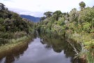
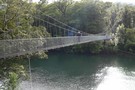
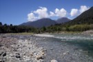
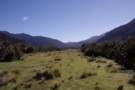
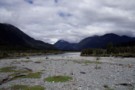
The Awarua River
Photograph
•
Distance: 688m away
Taken from the bridge about 10 minutes from the Big Bay hut.
More ▶︎
Hollyford Track
Track
•
4 days. Medium. One way.
•
Distance: 726m away
The Hollyford Track is a classic lowland Fiordland route from the Hollyford Road out to the coast at Martins Bay.
More ▶︎
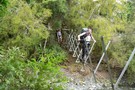
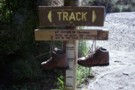
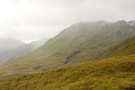
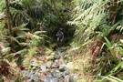
THE START OF THE DEMON TRAIL
Photograph
•
Distance: 726m away
Over this bridge the trail starts to live up to its name
More ▶︎
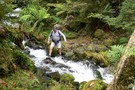
If water is touching soles of boots the stream may be too deep to cross
Photograph
•
Distance: 850m away
Kind of says it all, really. This is at Jerusalem Creek, about halfway between Martins Bay Lodge and Martins Bay ...
More ▶︎
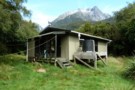
Big Bay hut
Photograph
•
Distance: 885m away
Very hard to find if you are coming from Martins Bay. The whole area between the sand dunes at Big ...
More ▶︎
Lake Alabaster Hut
Hut
•
Serviced Hut (DOC). Capacity: 26.
•
Distance: 919m away
Second hut on the Hollyford Track.
More ▶︎
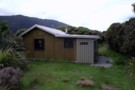
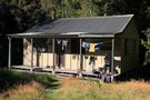
Big Bay Hut
Hut
•
Standard Hut (DOC). Capacity: 9.
•
Distance: 964m away
Big Bay Hut (9 bunk, stove, limited firewood, tank water) is a house just above the beach in the remote ...
More ▶︎
Lake Alabaster from the South
Photograph
•
Distance: 997m away
Taken from the beach about 5 minutes from the Lake Alabaster hut.
More ▶︎
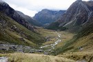
Final stretch of the Hollyford river
Photograph
•
Distance: 1.4km away
Looking towards Martins bay and the river mouth
More ▶︎
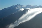
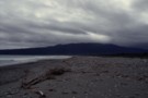
Rain Clouds
Photograph
•
Distance: 1.7km away
Distant rain cloud from Martins Bay Hut, Hollyford Track, Fiordland National Park
More ▶︎
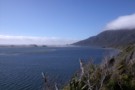
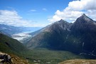
Hollyford Valley from Martins Bay
Photograph
•
Distance: 1.7km away
Looking back to the Hollyford from Martin's Bay
More ▶︎
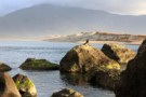
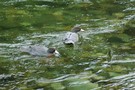
Martin's Bay seal
Photograph
•
Distance: 1.7km away
After 5 days walking in on the Hollyford Track in March 2010 we visited the seal colony and back near ...
More ▶︎
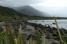
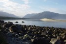
Three Mile Beach at Big Bay
Photograph
•
Distance: 2.5km away
Windswept, stoney and very uncomfortable to walk on. On the bright side theres plenty of driftwood if you feel like ...
More ▶︎
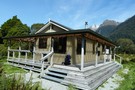
MARTINS BAY HUT
Photograph
•
Distance: 2.6km away
That is the hut behind the bush. Absolutly lovely
More ▶︎
Martins Bay Hut
Hut
•
Serviced Hut (DOC). Capacity: 20.
•
Distance: 2.6km away
Martins Bay Hut is a large modern hut in an amazing location overlooking the sandbar between Lake McKerrow and the ...
More ▶︎
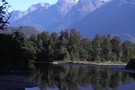
View from Lake Alabaster
Photograph
•
Distance: 2.9km away
mountain shot from Lake Alabaster
More ▶︎
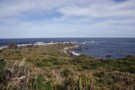
Long Reef
Photograph
•
Distance: 3.3km away
About 20 minutes past Martins bay hut, a seal colony lives here. Well worth the muddle scramble to visit.
More ▶︎
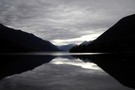
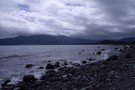
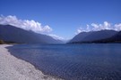
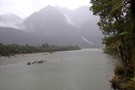
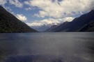
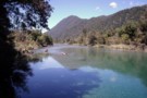
Lake McKerrow
Photograph
•
Distance: 3.6km away
From the North end of Lake McKerrow looking South up the lake.
More ▶︎
Big Bay
Photograph
•
Distance: 4.6km away
Looking across Big Bay from a bit past Penguin Rock. 4 hours of walking on rocks really kills your ankles!
More ▶︎
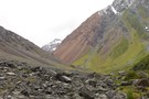
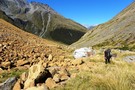
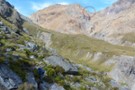
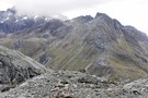
Scree Slopes in Hidden Falls Creek
Photograph
•
Distance: 5.7km away
An interesting mix of colours awaits you when you ascend Hidden Falls Ck toward Cow Saddle.
More ▶︎
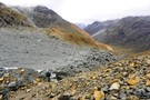
Heading down Hidden Falls creek
Photograph
•
Distance: 5.8km away
Leaving the campsite in Cow saddle after a morning of relaxation and clothes drying. It's just an afternoons walk to ...
More ▶︎
Five Passes
Track
•
6 – 7 days. Medium/hard. Loop track.
•
Distance: 5.8km away
A classic trip starting and finishing at the Routeburn road.
The five passes are; Sugarloaf pass, Park pass, Cow saddle, Fiery ...
More ▶︎
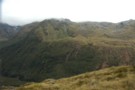
Cow saddle
Photograph
•
Distance: 5.9km away
On the five passes route. Cow saddle with Fiery col in the background. taken Jan 2010
More ▶︎
Ultramafic rocks, Hidden Falls Creek
Photograph
•
Distance: 5.9km away
On the five passes route. Ultramafic rocks in upper Hidden Falls creek. taken Jan 2010
More ▶︎
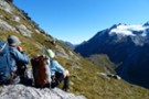
Here comes the cold half of the day
Photograph
•
Distance: 5.9km away
We didn't start walking until after midday and now with the descent from Fiery Col complete we settle down in ...
More ▶︎
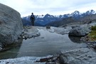
McKerrow Island ford
Photograph
•
Distance: 5.9km away
Crossing site to reach McKerrow Island. Not very passible with the Hollyford river in flood!
More ▶︎
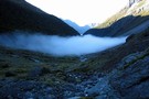
Morning mist, Hidden Falls creek
Photograph
•
Distance: 5.9km away
On the five passes route. Morning mist in upper Hidden Falls creek, not far from Cow saddle. taken Jan 2010
More ▶︎

Five Passes via Lake Nerine and North Col
Article
•
Distance: 6.0km away
A classic tramp north of the Routeburn. Rather than exit via the Rockburn, we extended the trip through Lake Nerine ...
More ▶︎
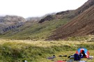
Camp on Hidden Falls Creek
Photograph
•
Distance: 6.0km away
looking upstream, our campsite high on Hidden Falls Creek was a little exposed but above the early morning mist
More ▶︎
The Olivine Ledge
Photograph
•
Distance: 6.5km away
At around 1100M a grassy ledge takes you from a short distance down from Fiery Col to the outlet from ...
More ▶︎
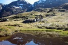
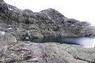
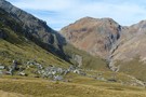
McKerrow Island Hut
Photograph
•
Distance: 6.9km away
basic hut with "emergency shower" (dip in the lake)
More ▶︎
McKerrow Island Hut
Hut
•
Standard Hut (DOC). Capacity: 12.
•
Distance: 6.9km away
Alternative hut located at the head of Lake McKerrow on the Hollyford Track. The hut is located on an island, ...
More ▶︎
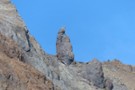
Menhir at Fiery Col
Photograph
•
Distance: 7.0km away
Approaching Fiery Col from the Olivine Ledge, there is a small but distinct menhir off to the right - Penguin ...
More ▶︎
Fiery Col menhir
Photograph
•
Distance: 7.0km away
Photo Feb 2013, having begun the climb from the Olivine Ledge towards the Col
More ▶︎
Lake Alabaster from the North
Photograph
•
Distance: 7.0km away
Taken from the Northern head of the lake looking South. 3 hours of wading in the lake awaits to reach ...
More ▶︎
Hokuri Creek
Photograph
•
Distance: 7.0km away
Looking upstream from the mouth of the Hokuri Creek where it flows into Lake McKerrow, a short distance North of ...
More ▶︎
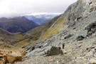
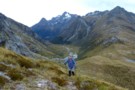
The descent to Cow Saddle from Fiery Col
Photograph
•
Distance: 7.3km away
Already down some 50m from the Col and the saddle area is coming into view. It's still another 4-500m to ...
More ▶︎
Fiery Col in fine weather
Photograph
•
Distance: 7.4km away
It's the first time i've come through here in clear weather.
What a view. We didn't get going till 1pm today. ...
More ▶︎
Fiery Col
Photograph
•
Distance: 7.4km away
looking across Cow Saddle into Hidden Falls Creek
Feb 2013
More ▶︎
Fiery col from Olivine Ledge
Photograph
•
Distance: 7.4km away
On the five passes route. Fiery col (on the left) from Olivine Ledge. taken Jan 2010
More ▶︎
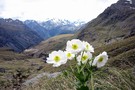
Olivine Ledge
Photograph
•
Distance: 7.5km away
On the five passes route. View of the Olivine Ledge from just below Fiery col. And a Mt Cook lily ...
More ▶︎
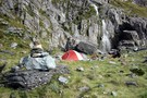
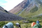
Fiery creek campsite
Photograph
•
Distance: 7.9km away
On the five passes route. Camping by Fiery creek. taken Jan 2010
More ▶︎
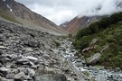
Pyke River
Photograph
•
Distance: 8.0km away
The Pyke, about halfway between Pyke Crossing and Lake Wilmot.
More ▶︎
Hidden Falls Hut
Hut
•
Serviced Hut (DOC). Capacity: 12.
•
Distance: 8.1km away
Hidden Falls Hut (12 bunk, stove, firewood available) is a serviced hut about 1.5-2.5 hours from the Hollyford roadend on ...
More ▶︎
Demon Trail Hut
Hut
•
Serviced Hut (DOC). Capacity: 12.
•
Distance: 8.1km away
Demon Trail Hut (serviced, 12 bunks, stove, firewood) marks the southern end of the infamous Demon Trail. Between the Hollyford ...
More ▶︎
Olivine Wilderness Area
Place
•
Wilderness Area. 830.00km2.
•
Distance: 8.2km away
Remote country in the Olivine Range. The wilderness area includes the Red Hills, the Olivine Ice Plateau, and the Joe ...
More ▶︎
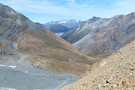
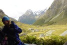
Park Pass and the Rockburn
Photograph
•
Distance: 8.3km away
the climb to Park Pass Glacier opens views down the Rockburn and the sidle to Lake Nerine
Feb 2013
More ▶︎
Hokuri Hut
Hut
•
Serviced Hut (DOC). Capacity: 12.
•
Distance: 8.4km away
A new hut on a terrace above lake McKerrow on the Hollyford Track.
Hokuri marks the coastward end of the infamous ...
More ▶︎
The Serpentine Range and the Three Passes
Article
•
Distance: 8.5km away
A six day trip around the Three Passes, including a traverse of the Serpentine Range instead of the North Route ...
More ▶︎
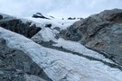
Park Pass Glacier
Photograph
•
Distance: 8.5km away
some of the breath-taking scenery on the descent from the glacier
Feb 2013
More ▶︎
Park Pass
Photograph
•
Distance: 8.5km away
On the five passes route. The upper Rock Burn from Park Pass. taken Jan 2010
More ▶︎
Rockburn - Lake Nerine - North Routeburn
Track
•
3 – 5 days. Medium. Loop track.
•
Distance: 8.5km away
A slightly shorter option to the 5 passes trip but of similar if not more difficulty. Can be done in ...
More ▶︎
View of the Rockburn from Park Pass Bivvy
Photograph
•
Distance: 8.6km away
As you ascend the Rockburn, perhaps as part of the Five Passes Walk, you can take advantage of a rock ...
More ▶︎
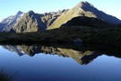
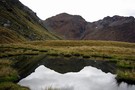
Early morning reflection
Photograph
•
Distance: 8.6km away
Taken from the top of Park Pass looking south towards the route into Lake Nerine
More ▶︎
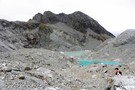
Terminal lakes of Park Pass glacier
Photograph
•
Distance: 8.6km away
To the north of Park Pass (1175m) is Poseidon Pk(2208m) from which flows Park Pass glacier to appx 1500m. It ...
More ▶︎
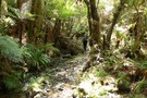
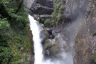
The Hidden Falls
Photograph
•
Distance: 8.7km away
Located on the Hollyford track about 3 hours from the carpark.
More ▶︎
Fiery Col
Photograph
•
Distance: 8.8km away
taken from the 1200m highpoint on the Olivine Ledge
Feb 2013
More ▶︎
The route to Lake Nerine from Park Pass
Photograph
•
Distance: 8.8km away
Looking from the moraine of Park Pass glacier, the steep snowgrass slopes can be seen to the south. These slopes ...
More ▶︎
Pyke Airstrip
Photograph
•
Distance: 8.8km away
The last good camping to be had here if you push on past Pyke Crossing.
More ▶︎
Park Pass Glacier
Photograph
•
Distance: 8.8km away
a highly recommended side trip on the 5 Passes tramp
Feb 2013
More ▶︎
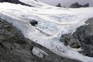
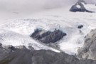
Park Pass glacier - close up the snout.
Photograph
•
Distance: 8.9km away
The neve certainly looks very accessible from the terminal end. It was only the time factor which disallowed us the ...
More ▶︎
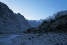
Pyke Crossing
Photograph
•
Distance: 9.0km away
A large braided river crossing, it was 3 or 4 seperate water channels seperated by gravel islands when this photo ...
More ▶︎
Close up of Park Pass Glacier
Photograph
•
Distance: 9.1km away
Showing the snout of the glacier with the tip obscured by the rock wall. Taken from above the steep snowgrass ...
More ▶︎
to Lake Nerine
Photograph
•
Distance: 9.4km away
on the sidle to Lake Nerine, looking back to Park Pass Glacier
More ▶︎
Alabaster Pass from the Olivine ledge
Photograph
•
Distance: 9.5km away
Looking from the ledge at the Olivine river and the flats on the river at the base of Alabaster Pass. ...
More ▶︎
Looking back towards Park Pass
Photograph
•
Distance: 9.5km away
It is a steep snowgrass sidle from Park Pass to this point but the view is rewarding
More ▶︎