Nearby
Edwards River, Lake Guyon, Fowler Pass circuit
Section: Edwards River - McArthur Track
Track
•
2 days. Easy/medium. One way.
•
Distance: less than 100m away
The southernmost section of the St James Cycle Trail, between Tophouse Road and the Lake Guyon junction on the Waiau ...
More ▶︎
Edwards River Track
GPX file
•
Distance: less than 100m away
Tophouse Road to Scotties Camp Hut, in the St James Conservation Area.
More ▶︎
Maling Pass, Lake Guyon, Fowler Pass circuit
Track
•
2 days. Easy/medium. Loop track with a road section.
•
Distance: less than 100m away
This circuit is a double-crossing of the St James Range, dropping into the deep Waiau Uwha Valley. The first day's ...
More ▶︎
Section: Lake Guyon - Fowler Pass
Track
•
1 day. Easy/medium. One way.
•
Distance: less than 100m away
A route connecting the Waiau Uwha and Waiau Toa (Clarence) valleys, from Lake Guyon junction on the St James Cycle ...
More ▶︎
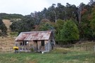
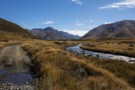
Fowlers Hut
Photograph
•
Distance: less than 100m away
Historic rabbiters' hut next to Tophouse Road in the St James Conservation Area. The Fowlers Pass Track starts here. A ...
More ▶︎
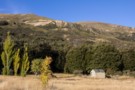
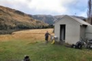
Fowlers Hut
Hut
•
Shelter (DOC).
•
Distance: less than 100m away
Historic hut on Tophouse Road, St James Conservation Area. The hut is being managed as a roadside shelter, and is ...
More ▶︎
Fowler Pass Track
GPX file
•
Distance: less than 100m away
From Lake Guyon and Stanley Vale, a zig zag up to Fowler Pass then the long straight run out to ...
More ▶︎

St James Conservation Area
Place
•
Place. 781.96km2.
•
Distance: 403m away
A large new recreational area featuring tussock grasslands, and including the headwaters of the Waiau and Clarence Rivers.
More ▶︎
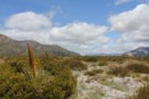
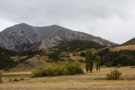
Peters Valley Track
Photograph
•
Distance: 3.9km away
Near Tophouse Road behind Hanmer Springs.
More ▶︎
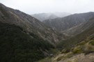
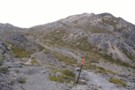
Near Fowler Pass
Photograph
•
Distance: 4.1km away
Climbing past Anniversary Point on the way to the zig zag.
More ▶︎
Molesworth Recreation Reserve
Place
•
Reserve. 1807.87km2.
•
Distance: 5.1km away
An iconic high country station located behind the Kaikoura Ranges.
More ▶︎
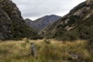
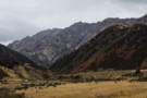
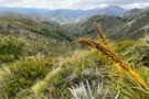
Old fencing, Stanley Vale
Photograph
•
Distance: 5.8km away
The route to Fowler Pass, following the Stanley River between Mount Laura on left and Rabbit Hill on right. Long ...
More ▶︎
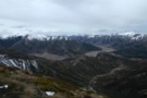
Stanley River Valley
Photograph
•
Distance: 7.6km away
One of the routes out of Stanley Vale.
More ▶︎
Mt Dumblane
Track
•
1 day. Easy/medium. Return by the same track.
•
Distance: 7.8km away
An alternative to the more popular Mt Isobel at Hanmer Springs, this track is an easy climb with a reward ...
More ▶︎
Hanmer Forest Conservation Park
Place
•
Conservation Park. 130.00km2.
•
Distance: 7.8km away
This park surrounding Hanmer Springs is popular with families, offering easy walking and biking through both exotic and indigenous forests.
More ▶︎
Malings Pass, L. Guyon, Stanleyvale, Sandy Stream Circuit
Article
•
Distance: 7.9km away
2 day circuit with the first day in spectacular scenery on the St James cycleway with a 500m ascent of ...
More ▶︎
Stanley Vale
Photograph
•
Distance: 8.0km away
Retired pastoral land around Stanley Vale Hut.
More ▶︎
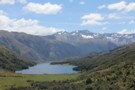
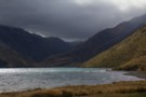
Lake Guyon
Photograph
•
Distance: 8.5km away
Mount Una (2300m) in behind. The hut is located on the distant grass flat.
More ▶︎
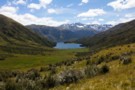
Lake Guyon
Photograph
•
Distance: 8.5km away
Mount Una (2300m) in behind. The hut is located on the distant grass flat.
More ▶︎
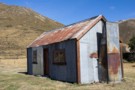
Stanley Vale Hut
Photograph
•
Distance: 8.6km away
Historic homestead at Stanley Vale in the St James Conservation Area.
More ▶︎
Stanley Vale Hut
Hut
•
Basic Hut/Bivvy (DOC). Capacity: 7.
•
Distance: 8.6km away
An historic farming homestead on the Stanley Vale Run, built by Joseph Young about 1866. The hut is built of ...
More ▶︎
View northwest from Mount Isobel
Photograph
•
Distance: 8.8km away
Waiau Toa / Clarence River in the distance.
More ▶︎
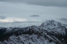
Mount Isobel
Photograph
•
Distance: 8.9km away
Poled route leading to the summit of Mount Isobel (1319m).
More ▶︎
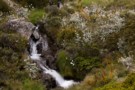
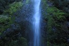
Dog Stream Waterfall
Photograph
•
Distance: 8.9km away
The Dog Stream waterfall, Upper Dog Stream track, just below link track to Mount Isobel
More ▶︎
Mount Isobel
Track
•
Easy/medium. Return via same track..
•
Distance: 8.9km away
A brief climb to the peak behind Hanmer Springs.
More ▶︎
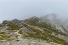
Misty approach to Mount Isobel
Photograph
•
Distance: 9.0km away
Poled route ascends easily to the summit.
More ▶︎
Section: Maling Pass - Moki Track
Track
•
1 day. Easy/medium. One way.
•
Distance: 9.4km away
The northernmost section of the St James Cycle Trail, between Lake Tennyson and the Lake Guyon junction on the Waiau ...
More ▶︎
Maling Pass to Lake Guyon junction
GPX file
•
Distance: 9.4km away
Northernmost section of the St James Cycle Trail
More ▶︎
Maling Pass to Lake Guyon
GPX file
•
Distance: 9.4km away
From Lake Tennyson, cross Maling Pass into the deep Waiau Valley, then turn off to Lake Guyon.
More ▶︎
Maling Pass Track
Photograph
•
Distance: 9.8km away
The start of the 4WD road over Maling Pass. This road is open to vehicles and bikes.
Lake Tennyson is ...
More ▶︎
Circuit from Stanley Vale to Glenrae Saddle/Lake Hill/Lake Guyon
Article
•
Distance: 10.0km away
A day's tramping to an seldom visited picturesque area near the St James Cycleway.
More ▶︎