Nearby
New Dredge Lake

Haast to The Divide
GPX file
•
Distance: 404m away
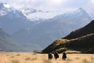
Andrew Barker's traverse 2009. From Pleasant Flat in the Haast to The Divide via Mt Aspiring National Park.
More ▶︎
Rees - Dart
GPX file
•
Distance: 2.8km away
Starting at Muddy Creek, this track heads up the Rees River to the head of the valley with a short ...
More ▶︎
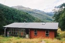
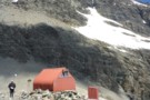
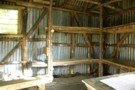
Daley's Flat Hut
Hut
•
Serviced Hut (DOC). Capacity: 20.
•
Distance: 4.4km away
This is the oldest hut on the Rees Dart route but is a welcome stop over on the long trip ...
More ▶︎
Daley's Flat Hut
Photograph
•
Distance: 4.4km away
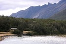
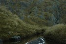
Looking south west down the Dart River. Heavy rain overnight saw the Dart river rise to the top of it's ...
More ▶︎
Daley's Flat Hut
Photograph
•
Distance: 4.4km away
Half way up the Dart Valley. This hut is on the Rees Dart track
More ▶︎
Rees-Dart Track
Track
•
3 – 4 days. Medium/hard. Loop track.
•
Distance: 4.7km away
Alpine circuit along two river valleys at the head of Lake Wakatipu.
More ▶︎
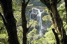
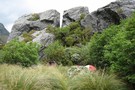
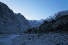
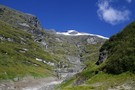
Beans Burn waterfall
Photograph
•
Distance: 5.2km away
On the five passes route. Waterfall mid Beans Burn. taken Jan 2010
More ▶︎

Five Passes via Lake Nerine and North Col
Article
•
Distance: 5.9km away
A classic tramp north of the Routeburn. Rather than exit via the Rockburn, we extended the trip through Lake Nerine ...
More ▶︎
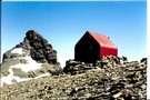
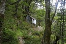
Esquilant Bivvy Hut
Hut
•
Serviced Alpine Hut (NZAC). Capacity: 6.
•
Distance: 5.9km away
Small hut located on Wright's Col in the Rees Valley.
More ▶︎
Mt Earnslaw
Article
•
Distance: 6.1km away
This was a sweet day trip taken in Feb 2008, bluebird day.
More ▶︎
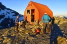
Esquilant Biv
Photograph
•
Distance: 6.5km away
Gearing up in the early morning to climb Mt Earnslaw. Esquilant is a 6 bunk hut situated at 2,160m.
More ▶︎
Esquilant Biv
Photograph
•
Distance: 6.6km away
A small 6-bunk hut on the shoulder of Mt Earnslaw. Could comfortably sleep 8, although there is not much room ...
More ▶︎
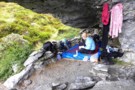
Beans Burn camp
Photograph
•
Distance: 7.2km away
On the five passes route. Camping next to the Beansburn rock biv -- there is room for a couple of ...
More ▶︎
The upper Beansburn from the rock bivvy
Photograph
•
Distance: 7.2km away
Some rain appears on the lens as it blows directly into the bivvy site. Good for us we can get ...
More ▶︎
Five Passes
Track
•
6 – 7 days. Medium/hard. Loop track.
•
Distance: 7.4km away
A classic trip starting and finishing at the Routeburn road.
The five passes are; Sugarloaf pass, Park pass, Cow saddle, Fiery ...
More ▶︎
beansburn track
Track
•
3 – 5 days. Medium. Return via same track.
•
Distance: 7.5km away
a route that follows the beansburn valley. lake unknown can be reached from here.
times:
beansburn mouth-rock bivvy no 1 1-1.5 ...
More ▶︎
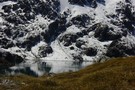
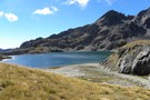
Lake Unknown
Photograph
•
Distance: 7.7km away
Lake Unknown lies high between the Beans Burn & the Rockburn. The Dart Valley is visible behind about 750 meters ...
More ▶︎
Beans Burn
Photograph
•
Distance: 8.2km away
On the five passes route. Upper Beans Burn valley from just below Fohn saddle. taken Jan 2010
More ▶︎
Olivine Wilderness Area
Place
•
Wilderness Area. 830.00km2.
•
Distance: 8.4km away
Remote country in the Olivine Range. The wilderness area includes the Red Hills, the Olivine Ice Plateau, and the Joe ...
More ▶︎
Mt Tantalus
Photograph
•
Distance: 8.7km away
Mt Tantalus over the Fohn Saddle. The Fohn Saddle is about the mid-point of the 5 passes tramp
More ▶︎
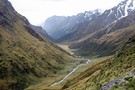
Down the Beansburn
Photograph
•
Distance: 8.8km away
looking down the Beansburn - on the climb to Fohn Pass
Feb 2013
More ▶︎
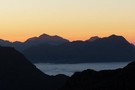
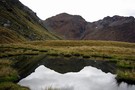
Fohn Lake
Photograph
•
Distance: 8.9km away
taken from above Fohn Pass, one possible route to the lake descends the gully on the right and sidles to ...
More ▶︎
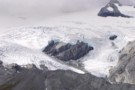
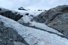
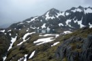
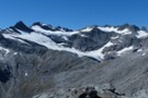
Close up of Park Pass Glacier
Photograph
•
Distance: 8.9km away
Showing the snout of the glacier with the tip obscured by the rock wall. Taken from above the steep snowgrass ...
More ▶︎
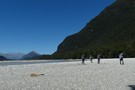
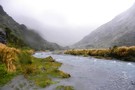
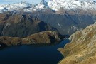
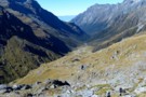
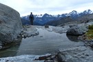
Dart River
Photograph
•
Distance: 9.0km away
looking down the Dart - about to head into the forest
Feb 2013
More ▶︎
Fohn lake - Mt.Aspiring NP NZ
Photograph
•
Distance: 9.0km away
Along the Five Passes route and below Fohn saddle. The lake sits above the Olivine ledge. Fine weather at lunchtime.
March ...
More ▶︎
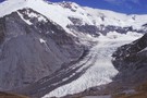
Park Pass Glacier
Photograph
•
Distance: 9.1km away
a highly recommended side trip on the 5 Passes tramp
Feb 2013
More ▶︎
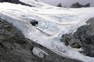
Park Pass glacier - close up the snout.
Photograph
•
Distance: 9.1km away
The neve certainly looks very accessible from the terminal end. It was only the time factor which disallowed us the ...
More ▶︎
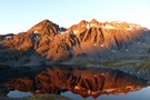
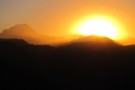
Sunset from Fohn Lake
Photograph
•
Distance: 9.3km away
looking W from the knoll above Fohn Lake
Feb 2013
More ▶︎
Sunset on Sunset Peak
Photograph
•
Distance: 9.3km away
deepening colours as the sun sets
Feb 2013
More ▶︎
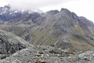
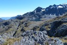
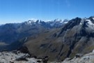
The route to Lake Nerine from Park Pass
Photograph
•
Distance: 9.3km away
Looking from the moraine of Park Pass glacier, the steep snowgrass slopes can be seen to the south. These slopes ...
More ▶︎
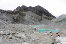
Terminal lakes of Park Pass glacier
Photograph
•
Distance: 9.3km away
To the north of Park Pass (1175m) is Poseidon Pk(2208m) from which flows Park Pass glacier to appx 1500m. It ...
More ▶︎
Fohn Lake
Photograph
•
Distance: 9.3km away
On the five passes route. Fohn lake with Sunset Peak (1800m) behind it. taken Jan 2010
More ▶︎
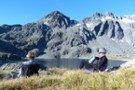
Fohn Lake
Photograph
•
Distance: 9.4km away
relaxing in the early evening - a great camp beside the tarn and below the aptly named Sunset Peak
More ▶︎
Park Pass Glacier
Photograph
•
Distance: 9.4km away
some of the breath-taking scenery on the descent from the glacier
Feb 2013
More ▶︎
Matukituki to Paradise by roads less travelled
GPX file
•
Distance: 9.4km away
A rough, tough crossing from Raspberry Flat (Aspiring Road, Wanaka) to the Earnslaw Burn (Glenorchy-Paradise road) via Shotover Saddle, Lochnagar, ...
More ▶︎
Fohn Lake sunset
Photograph
•
Distance: 9.5km away
Feb 2013. Sun setting behind the Bryneira Range as seen from point 1501
More ▶︎
Kea Basin Bivvy - Mt.Earnslaw
Photograph
•
Distance: 9.5km away
This is one of the best bivvy rocks i've seen. Situated at appx 1060m on the north flank of Mt.Earnslaw. ...
More ▶︎
Merkl Glacier
Photograph
•
Distance: 9.5km away
photo taken from the easily reached Sunset Peak, looking NE. Feb 2013
More ▶︎
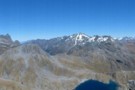
Sunset panorama
Photograph
•
Distance: 9.6km away
panorama from Sunset Peak, looking NE to NW.
From Skippers Range, across Lake Wilmot & Olivine River, Terminal Peak to the ...
More ▶︎
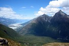
Sunset Peak
Photograph
•
Distance: 9.6km away
panorama from the summit of Sunset Peak - looking S to E across Fohn Pass and Lake and Fiery Col ...
More ▶︎
Lennox Creek, South Branch
Photograph
•
Distance: 9.7km away
Upper crossing of Lennox Creek (south branch). Not a place to be with unstable snow above.
The next viable crossing is ...
More ▶︎
Looking inside Earnslaw Hut - Mt.Aspiring NP
Photograph
•
Distance: 9.7km away
An old hut with a distinctive rustic look. I believe many people would prefer to occupy the rock bivvy at ...
More ▶︎
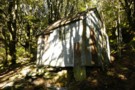
Earnslaw Hut - Mt.Earnslaw - Mt.Aspiring NP
Photograph
•
Distance: 9.7km away
At appx 980m set in beech forest above the Rees valley. This historic hut is on a short 50m side ...
More ▶︎
Earnslaw Hut
Hut
•
Basic Hut/Bivvy (DOC). Capacity: 4.
•
Distance: 9.7km away
Earnslaw hut. Located near Kea Basin on the slopes of Mt Earnslaw, above the Rees valley.
More ▶︎
Earnslaw Hut
Photograph
•
Distance: 9.7km away
Rough four-bunk historic hut below Kea Basin on the ascent to Mt Earnslaw
More ▶︎
Fiery col from Olivine Ledge
Photograph
•
Distance: 9.9km away
On the five passes route. Fiery col (on the left) from Olivine Ledge. taken Jan 2010
More ▶︎