Nearby
Bob's Hut

Blue Lake Hut - Bobs Hut
GPX file
•
Distance: less than 100m away
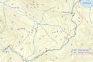
Blue Lake campsite to Bob’s Hut, via Lake Thompson and D’Urville Pass
An actual, recorded, gpx – the high route section ...
More ▶︎

Profile : St Arnaud - Lewis Pass
Photograph
•
Distance: less than 100m away
A useful profile of the 100km tramp - with a couple of bad weather alternatives :
1. low route past Speargrass ...
More ▶︎
St Arnaud - Lewis Pass
Article
•
Distance: less than 100m away
A 9-day 100km tramp via the Thompson, D'Urville and 3 Tarns Passes
Feb 2013
More ▶︎
Picton to Aspiring
GPX file
•
Distance: 108m away
An aborted alpine traverse. Picton to West Cape, but aborted at Aspiring due to real world emergencies back home. Posted ...
More ▶︎
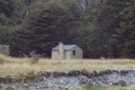
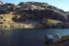
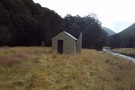
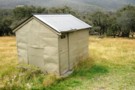
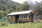
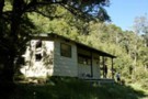
Bob's Hut
Photograph
•
Distance: 163m away
Bob's Hut, located in wide valley flats on the west branch of the Matakitaki River.
More ▶︎

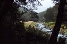
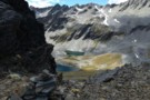
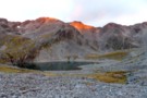
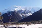
Lake Thompson
Photograph
•
Distance: 163m away
A view of the beautiful Lake Thompson, a short distance from Thompson Pass
More ▶︎
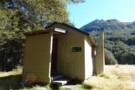
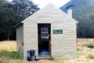
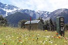
Bob's Hut
Hut
•
Standard Hut (DOC). Capacity: 8.
•
Distance: 163m away
Bob was to be absent when I arrived - though a cross outside hints at possible reasons. Hut book entries ...
More ▶︎

Route Guide: St Arnaud to Lewis Pass
Article
•
Distance: 163m away
A 5-7 day north-south route from St Arnaud to the Lewis Pass, via Travers Pass, Waiau Pass, Thompson Pass and ...
More ▶︎
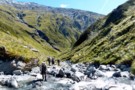
West Matakitaki valley
Photograph
•
Distance: 2.8km away
West Matakitaki valley, heading from Bob's Hut to Three Tarn Pass
More ▶︎
W Matakitaki - Ada Pass Hut
GPX file
•
Distance: 3.8km away
Treeline in West Matakitaki Valley to Ada Pass Hut, via 3 Tarns Pass
An actual, recorded, gpx – the only thing ...
More ▶︎
St Arnaud to Lewis Pass
Track
•
5 – 9 days. Medium/hard. One way.
•
Distance: 4.3km away
A 5-9 day north-south route from St Arnaud to the Lewis Pass, via Travers Pass, Waiau Pass, Thompson Pass and ...
More ▶︎
West Matakitaki Valley
Photograph
•
Distance: 5.4km away
traveling up the valley to 3 Tarns, it's easiest to keep to the river until the last push to the ...
More ▶︎
Three Tarns, Three Tarns Pass
Photograph
•
Distance: 5.7km away
Three Tarns, Three Tarns Pass - at the head of the West Matakitaki Valley
More ▶︎
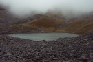
3 Tarns Pass
Photograph
•
Distance: 6.1km away
from the Pass, looking back to the 3 tarns
the better camping is on the south side of the pass
Feb 2013
More ▶︎
Thompson Pass
GPX file
•
Distance: 6.1km away
Caroline Creek Hut, Upper Waiau Valley to East Matakitaki Hut via Thompson Pass & Unamed Pass
More ▶︎
Thompson Pass
GPX file
•
Distance: 6.1km away
Caroline Creek Hut, Upper Waiau Valley to East Matakitaki Hut via Thompson Pass & Unamed Pass
More ▶︎
East Matakitaki Hut
Photograph
•
Distance: 6.1km away
beside the river and at the southern end of the flats, we found this 6-berth hut in great condition
Feb 2013
More ▶︎
East Matakitaki Hut
Photograph
•
Distance: 6.2km away
East Matakitaki Hut in the east branch of the Matakitaki Valley.
More ▶︎
East Matakitaki Hut
Hut
•
Standard Hut (DOC). Capacity: 6.
•
Distance: 6.2km away
East Matakitaki Hut (6 bunk, matresses, fireplace, creek water) lies on river flats in the upper Matakitaki valley (east branch). ...
More ▶︎
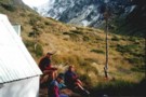
South side of 3 Tarns Pass
Photograph
•
Distance: 6.6km away
campsite and tarn as sunset approaches
Feb 2013
More ▶︎
Burn Ck Bivvy
Photograph
•
Distance: 8.0km away
A basic 2 bunk bivvy that has seen better days.
Burn ck is fairly tight and gorgey with plenty of sidling ...
More ▶︎
Burn Creek Hut
Hut
•
Basic Hut/Bivvy (DOC). Capacity: 2.
•
Distance: 8.0km away
The little hut with a steep-pitched roof is located just under the Emily Peaks next to some beech forest. Given ...
More ▶︎
Upper Glenroy Hut [Removed]
Hut
•
Removed!
•
Distance: 8.5km away
Hut located on the upper Glenroy River. Removed about 2005.
More ▶︎
Ada Cullers Hut
Photograph
•
Distance: 8.6km away
Ada Cullers Hut is an historic Hut about 15 minutes from Christopher Hut on the St James Walkway. 4 bunks
More ▶︎
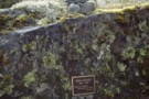
Max Smart memorial plaque, Matakitaki valley
Photograph
•
Distance: 8.7km away
Memorial plaque to Max Smart on the true left of the Matakitaki upriver of the East Matakitaki Hut. The quote ...
More ▶︎
Ada Cullers Hut
Hut
•
Basic Hut/Bivvy (DOC). Capacity: 4.
•
Distance: 8.7km away
Christopher (Ada) Cullers Hut.
More ▶︎
Lewis Pass National Reserve
Place
•
Reserve. 182.95km2.
•
Distance: 9.2km away
A small park occupying the forested valleys around Lewis Pass and bordering Lake Sumner and Victoria Forest Parks as well ...
More ▶︎

St James Walkway
Track
•
5 days. Easy/medium. One way.
•
Distance: 9.2km away
A long and easy walk on St James Station near Lewis Pass. Beech forest, mountain scenery, farmland, wild horses, mud.
More ▶︎
Boyle Flats Hut
Photograph
•
Distance: 9.2km away
Perched high on a river terrace, accessed from a swingbridge 'on the Boyle'.
More ▶︎
Ada Cullers Hut
Photograph
•
Distance: 9.2km away
Tidy old shack provides shelter and shade from the elements. No mattresses or water supply.
More ▶︎
St James Walkway June 2009
Photograph
•
Distance: 9.2km away
Gloriana and the Faerie Queene, on a brilliant winter's day.
More ▶︎
St James Conservation Area
Place
•
Place. 781.96km2.
•
Distance: 9.2km away
A large new recreational area featuring tussock grasslands, and including the headwaters of the Waiau and Clarence Rivers.
More ▶︎
Christopher Hut
Hut
•
Serviced Hut (DOC). Capacity: 14.
•
Distance: 9.2km away
Christopher hut.
More ▶︎
Ada Pass Hut
Photograph
•
Distance: 9.5km away
20-bunker nested into the bush edge with excellent sub-apline vista from the balcony.
More ▶︎
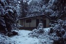
Ada Pass Hut
Photograph
•
Distance: 9.5km away
Ada Pass Hut after a seasonal March snowfall.
More ▶︎
Ada Pass Hut
Hut
•
Serviced Hut (DOC). Capacity: 20.
•
Distance: 9.5km away
Ada Pass Hut (sleeps 14 on platform beds, matresses, stove, tank & river water) is a large, comfortable two-room hut ...
More ▶︎
Cannibal Gorge, Ada Pass
Track
•
2 days. Easy. Return via same track.
•
Distance: 9.5km away
An easy overnighter through the pretty bush of Cannibal Gorge and on to the alpine views of Ada Pass.
More ▶︎
Christopher Hut
Photograph
•
Distance: 9.6km away
Christopher Hut on the Ada River. Part of the Saint James Walkway
More ▶︎