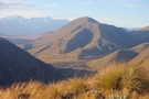
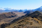
Nearby
Mt Barrosa
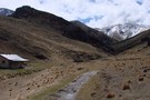
Mount Somers
Photograph
•
Distance: less than 100m away
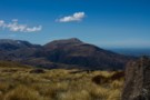
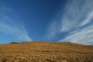
The view east from the smaller Mount Barrosa.
More ▶︎
Mt Barrosa
Track
•
1 day. Medium. Return by the same track.
•
Distance: less than 100m away
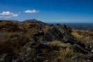
A volcanic summit (1364m) in the Clent Hills with sweeping views across the Ashburton Lakes basin.
More ▶︎
Barrosa
GPX file
•
Distance: less than 100m away
Poled route to the summit of Mount Barrosa, in the Clent Hills.
More ▶︎
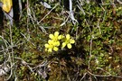
Scree buttercup
Photograph
•
Distance: 128m away
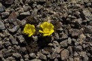
Ranunculus crithmifolius, mid-October, Mount Barrosa.
More ▶︎
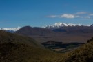
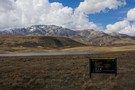
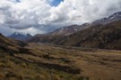
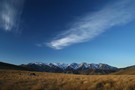
Ashburton Lakes
Photograph
•
Distance: 1.5km away
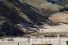
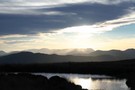
The view west from Mount Barrosa. Mount Guy (1319m) is in the foreground, with the sharp summit of distant Mt ...
More ▶︎
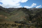
Manuka Range/West Stour area
Photograph
•
Distance: 4.2km away
Manuka Hut is found at the far end of this low range.If you`re keen on MTB riding,old farm tracks will ...
More ▶︎
Manuka Range/Stour R. Circuit
Track
•
2 – 3 days. Easy/medium. Loop track with a road section.
•
Distance: 4.2km away
2 day circuit extended to 3 days by going into Woolshed Creek via Burma Rd then traversing Manuka Range
More ▶︎
Miners Track to Woolshed Creek Hut
Track
•
Easy. Return via same track.
•
Distance: 5.8km away
This track follows, in part, the line the miners took to the old Blackburn Mine. The track, if accessed via ...
More ▶︎
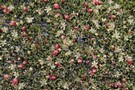
Muehlenbeckia axillaris
Photograph
•
Distance: 6.1km away
This species is widespread around the Blackburn Mine site, Mount Somers.
More ▶︎
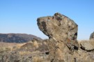
Snoopys head on Manuka range
Photograph
•
Distance: 6.7km away
To get to this rock you clime up behind the Manuka hut and it's an easy walk along the top ...
More ▶︎
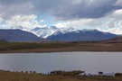
Lake Emily
Photograph
•
Distance: 7.4km away
Cameron Valley and the Arrowsmith Range beyond.
More ▶︎
Lake Emily and the Mount Somers Range
Photograph
•
Distance: 7.6km away
Mount Taylor (2333m) is the summit of the range.
More ▶︎
Woolshed Creek Hut surrounds
Photograph
•
Distance: 7.6km away
The steeply gorged rhyolite landscape around the new hut, with Woolshed Creek at left, Morgan Stream at right, and the ...
More ▶︎
Manuka Hut via Lake Emily
Track
•
Easy. Return by the same track.
•
Distance: 7.6km away
A short walk to a hut at the foot of the Mount Somers Range.
More ▶︎
Stour River
Photograph
•
Distance: 7.8km away
Looking north, Manuka Hut is just around the hook in the river at the end of the Manuka Range.
More ▶︎
Mt Somers Track (South Face)
Track
•
1 day. Easy/medium. Return by the same track.
•
Distance: 8.0km away
Woolshed Creek Hut - Rhyolite Ridge Track junction (4 km) Time: 2 hr. The route takes in dynamic scenery with ...
More ▶︎
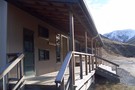
Woolshed Creek Hut
Hut
•
Serviced Hut (DOC). Capacity: 26.
•
Distance: 8.0km away
A new hut situated in a handsome tussock landscape on the Mount Somers Track. Ample camping nearby.
More ▶︎
Manuka Range
Photograph
•
Distance: 8.4km away
On top looking towards Mt Sugarloaf and Mt Catherine with Ricki Spur (left ) and Longman Range ( right )
More ▶︎
Ranunculus enysii
Photograph
•
Distance: 8.5km away
Growing in damp patches amongst tussocks on the slopes of Mount Somers.
More ▶︎
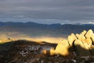
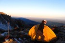
MtSomers sunrise
Photograph
•
Distance: 8.6km away
a couple of years ago,we camped at 1200m above the South Face of Mt Somers.Stunning light evening & morning,before we ...
More ▶︎
Gentle summit
Photograph
•
Distance: 8.9km away
The easy tussock slopes of the Mount Somers summit.
More ▶︎
Evening, Mount Somers tarns
Photograph
•
Distance: 8.9km away
Camping on the gentle tussock slopes at around 1270m.
More ▶︎
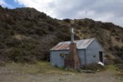
Manuka Hut
Photograph
•
Distance: 9.7km away
Simple musterers' hut on the Stour River at the foot of the Mount Somers Range.
More ▶︎
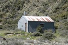
Manuka Hut
Hut
•
Basic Hut/Bivvy (DOC). Capacity: 6.
•
Distance: 9.7km away
A very basic hut near Lake Heron that is popular with Hunters. It is located 5 km away from Double ...
More ▶︎
Circuit of Branches of the Stour via Manuka Hut
Article
•
Distance: 9.7km away
Attractive alternative circuit via varied terrain.
More ▶︎