Nearby
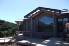
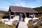
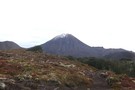
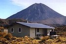
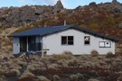
New Waihohonu Hut
Waihohonu Hut
Photograph
•
Distance: less than 100m away
This is a new DOC hut on the Tongariro Northern Circuit completed late DEC 2010. It is about a 5min ...
More ▶︎

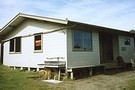
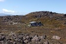
Waihohonu Hut
Photograph
•
Distance: 101m away
A typical lockwood Tongariro National Park Hut. It was supposed to be replaced but they have just built a new ...
More ▶︎
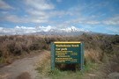
Round The Mountain (Ruapehu) - Stage 2
GPX file
•
Distance: 107m away
This is a pleasant two-day walk around the eastern part of the Round The Mountain (Ruapehu) Track. The walk begins ...
More ▶︎
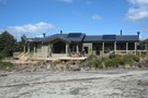
Waihohonu Hut
Hut
•
Great Walks Hut (DOC). Capacity: 28.
•
Distance: 110m away
The best hut on the Tongariro Northern Crossing. New flush! toilets. Three sleeping areas: one cosy room next to the ...
More ▶︎
Tongariro Northern Circuit
Track
•
3 – 4 days. Easy/medium. Loop track.
•
Distance: 110m away
This circuit on the Volcanic Plateau passes close to the summit of Tongariro in a spectacular, active volcanic landscape of ...
More ▶︎

Great Walks Information
Article
•
Distance: 110m away
The DOC Great Walks are a set of premium tramping tracks throughout New Zealand.
More ▶︎
Round the Mountain: Ruapehu
Track
•
5 days. Easy/medium. Loop track.
•
Distance: 110m away
Combined with part of the Tongariro Northern Circuit, this track forms a loop around Mt Ruapehu. Combined with the other ...
More ▶︎
Tongariro Northern Circuit
GPX file
•
Distance: 113m away
A complete log of the Tongariro Northern Circuit completed on March 8, 2008.
More ▶︎
Round The Mountain (Ruapheu)
GPX file
•
Distance: 116m away
Stage 1 Round The Mountain Track
More ▶︎
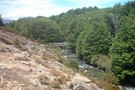
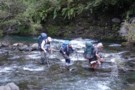
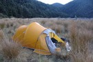
Waihohonu Bridge - Round The Mountain (Ruapehu)
Photograph
•
Distance: 175m away
Bridge near Waihohonu Hut - ideal area for lunch
More ▶︎
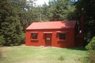
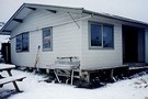
Historic Waihohonu Hut
Hut
•
Standard Hut (DOC).
•
Distance: 586m away
This original Waihohonu hut was constructed in 1904 and is now a historic building with no accommodation. You can stay ...
More ▶︎
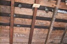
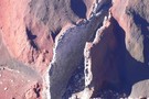
Old Waihohonu Hut graffiti
Photograph
•
Distance: 587m away
The youth of today!!!......graffiti on the rafters go back to at least 1918. If you are in the hut take ...
More ▶︎
Old Waihohonu Hut
Photograph
•
Distance: 605m away
This historic hut is well worth the side trip on the Round The Mountain Track (Stage 1) (Ruapehu)
More ▶︎
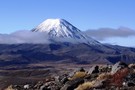
Mt Ngauruhoe - Tongariro Circuit
Photograph
•
Distance: 1.4km away
3 JUN 2011 - on the Tongariro circuit between Waihohonu and Oturere Huts. Approx 20min walk north of Waihohonu.
More ▶︎
Routes from Oturere Bridge to Oturere Hut
GPX file
•
Distance: 2.8km away
Some years ago the prospect of a fast shortcut from Oturere Bridge to Oturere Hut has facinated me. I have ...
More ▶︎

Oturere Hut
Hut
•
Great Walks Hut (DOC). Capacity: 26.
•
Distance: 5.6km away
A grand location on the east side of Ngauruhoe in the Tongariro National Park. The smallish living area has 2 ...
More ▶︎
Oturere Hut
Photograph
•
Distance: 5.6km away
Northern tongariro circiut hut Gas burners and fire, Water and WC. Would be an intereting hut to visit mid winter
More ▶︎
Mangahouhounui Stream
Track
•
2 days. Medium. One way.
•
Distance: 5.7km away
An untracked alternative to getting from Ketetahi Hut to Oturere Hut and beats the madenning crowd.
More ▶︎
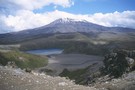
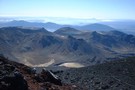
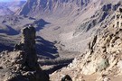
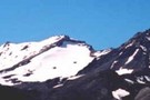
Lower Tama, Tama Saddle, and Ruapehu beyond
Photograph
•
Distance: 5.7km away
The Tama Lakes are old explosion craters remaining from past eruptions.
More ▶︎
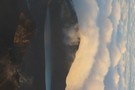
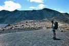
Lunarscape
Photograph
•
Distance: 6.6km away
It's a lunar like landscape that greets you after departing Oturere Hut for the Emerald Lakes.
Mount Ngarahoe offers a stunning ...
More ▶︎
Mangatoetoenui Stream - Round The Mountain (Ruapehu)
Photograph
•
Distance: 6.6km away
Upper reaches of the stream which is crossed by the track. Typical "desert" like landscape. View of Mt Ruapehu in ...
More ▶︎
Hard going in the Oturere Stream
Photograph
•
Distance: 6.7km away
Sometimes it is quite fun to get off track, sometimes it isn't. At least this bit only involved water and ...
More ▶︎
Tama Lakes Track
Track
•
Medium. Return via same track.
•
Distance: 6.8km away
A good day walk onto the Tama Saddle, visiting explosion craters near the foot of Ngauruhoe. Excellent panoramic views on ...
More ▶︎
Tongariro National Park World Heritage Area
Place
•
World Heritage Area. 795.96km2.
•
Distance: 6.8km away
Tongariro National Park was given to the Crown by the Ngati Tuwharetoa iwi in 1887, and became New Zealand's first ...
More ▶︎

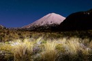
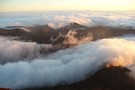
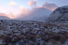
Ngauruhoe Sunrise
Photograph
•
Distance: 6.8km away
A midnight tramp under the moonlight, up through the clouds takes you to the summit of ngauruhoe, where the hot ...
More ▶︎
Waiting for the sun, Ngauruhoe
Photograph
•
Distance: 6.8km away
A midnight tramp under the moonlight, up through the clouds takes you to the summit of ngauruhoe, where the hot ...
More ▶︎
Ngauruhoe Summit
Photograph
•
Distance: 6.8km away
Early morning, lower tama lake full of mist
More ▶︎
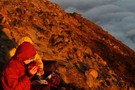
Warming Up on Ngauruhoe
Photograph
•
Distance: 6.8km away
After a cold night, the sunrise from the heated summit of ngauruhoe is incredible. Enjoying a well earned brew high ...
More ▶︎
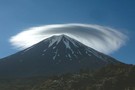
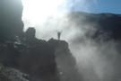
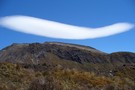
St Ngauruhoe blessing the trampers
Photograph
•
Distance: 6.8km away
As the sun rose we were greeted with this curious spectacle of a lenticular cloud wrapped about the cone of ...
More ▶︎

Tongariro National Park
Place
•
National Park. 790.00km2.
•
Distance: 6.8km away
New Zealand's first national park andand one of the first to be created anywhere in the world. The volcanic heart ...
More ▶︎
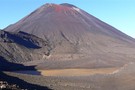
Mount Ngauruhoe
Photograph
•
Distance: 6.8km away
Ngauruhoe viewed from South Crater, Tongariro Alpine Crossing.
More ▶︎
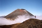
Ngauruhoe Volcano
Track
•
1 day. Medium. Returns via same track.
•
Distance: 6.9km away
Ascent of the steep, symmetrical scoria cone of a young volcano - can be walked as a 3 hour side ...
More ▶︎
Lower Tama Lake
Photograph
•
Distance: 6.9km away
I took my Canadian cousins up to Tama Lake. They thoroughly enjoyed the trip
More ▶︎
Lower Tama Lake
Photograph
•
Distance: 7.0km away
Worthwhile day trip from Whakapapa Village
More ▶︎
Traversing around Mt Tongariro
Photograph
•
Distance: 7.5km away
Heading towards Oturere hut from the Mangahouhounui Valley. Mt Ruapehu beyond
More ▶︎
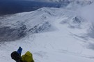
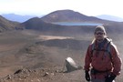
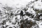
Winter ascent - Mt Ngauruhoe
Photograph
•
Distance: 7.5km away
70kph winds and swirling spindrift made for an interesting climb. Unfortunately we were turned back 50m from the summit by ...
More ▶︎
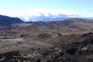
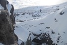
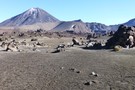
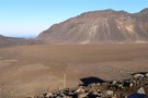
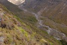
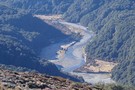
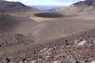
Oturere Valley
Photograph
•
Distance: 8.1km away
The Oturere Valley above Oturere Hut is a unique place. A real moonscape sculptured by lava flows
More ▶︎
New Track to Mangatepopo Saddle
GPX file
•
Distance: 8.3km away
Regular trampers into the Mangatepopo Valley may be interested in the route of the new, highly engineered track from the ...
More ▶︎
South Crater
Photograph
•
Distance: 8.3km away
South Crater viewed from the eastern rim, Tongariro Alpine Crossing.
More ▶︎

Tongariro Alpine Crossing
Track
•
1 day. Medium. One way.
•
Distance: 8.4km away
A popular but crowded alpine route through a spectacular volcanic landscape.
More ▶︎

Into the wild
Photograph
•
Distance: 8.4km away
After the aptly named Devils staircase. A rewarding stretch in the clouds. Perhaps this could be renamed the stairway to ...
More ▶︎
Sunrise over Red Crater and the Blue Lake
Photograph
•
Distance: 8.4km away
From the top of Ngauruhoe, sunrise spreads it's light across the familiar but deserted landscape of tongariro.
More ▶︎
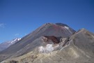
Rim of Red Crater
Photograph
•
Distance: 8.4km away
Standing on the rim of Red Crater at the summit, Blue Lake in the background.
More ▶︎
Below Red Crater
Photograph
•
Distance: 8.4km away
View from the rim of South Crater, below Red Crater
More ▶︎
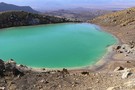
Emerald Lake - Winter
Photograph
•
Distance: 8.6km away
The lower Emerald Lake in its winter coat - taken June 2009. The track from Oturere Hut joins the Tongariro ...
More ▶︎
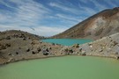
Emerald Lakes, Tongariro crossing
Photograph
•
Distance: 8.7km away
Very rare image of the Lakes with no tourists in shot (I got lucky)
More ▶︎
Mangahouhounui Stream
Photograph
•
Distance: 8.7km away
Looking down into the Mangahouhounui Stream
More ▶︎
Emerald Lakes
Photograph
•
Distance: 8.8km away
Emerald lake viewed from the descent from Red Crater.
More ▶︎
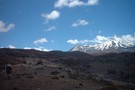
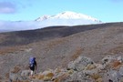
The Majestic Mountain
Photograph
•
Distance: 9.0km away
Ruapehu as the sun was setting and cloud hanging around
More ▶︎
Lower Waipakihi Valley
GPX file
•
Distance: 9.0km away
The route down the lower Waipakihi just follows the river. You can cut off about 5 minutes at the point ...
More ▶︎
Lower Waipakahi Valley
Track
•
1 – 2 days. Easy/medium. One way.
•
Distance: 9.0km away
A nice easy valley with very pleasant camping all the way along its length
More ▶︎
Mangahouhounui Stream
Photograph
•
Distance: 9.0km away
The Mangahouhounui Stream down where it entes the bush on a foggy morning
More ▶︎
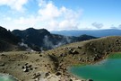
Blue Lake Panorama
Photograph
•
Distance: 9.2km away
Mt Ngauruhoe, Red Crater, Mt Tongariro, my wife Helen, Blue Lake.
We're all walking on the moon.
More ▶︎
Winter conditions - Tongariro Crossing
Photograph
•
Distance: 9.3km away
c1300m on a very average August morning.
More ▶︎
Soda Springs
Track
•
Easy. Return via same track.
•
Distance: 9.4km away
The easiest close approach to Ngauruhoe Volcano, following a smooth track through a raw, moonlike landscape to an oasis of ...
More ▶︎
Ngauruhoe under a super moon
Photograph
•
Distance: 9.6km away
A long exposure (and painting the foreground with my head torch) led to a pleasing result.
More ▶︎
Ruapehu, Ngauruhoe, and Red Crater
Photograph
•
Distance: 9.6km away
These volcanoes and vents line up along the axis of the Taupo Volcanic Zone, a line of geothermal activity leading ...
More ▶︎
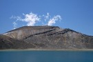
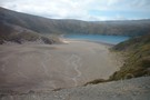
Blue Lake, Mount Tongariro
Photograph
•
Distance: 9.6km away
This lake occupies a crater next to the popular Tongariro Crossing track.
More ▶︎
Tongariro Massif at Dawn
Photograph
•
Distance: 9.6km away
From the summit of Ngauruhoe, the clouds flow past the summits of Tongariro. Not a tourist in sight! A full ...
More ▶︎
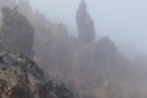
Lava in the mist
Photograph
•
Distance: 9.6km away
Low cloud obscured the views on the trail to the Mt Tongariro summit, but resulted in lava formations looming eerily ...
More ▶︎
Hiking the Tongariro Northern Circuit
Article
•
Distance: 9.6km away
The Tongariro Northern Circuit circles around Ngauruhoe's cone with chances to climb either Ngauruhoe or Tongariro. The entire circuit takes ...
More ▶︎
Mount Tongariro
Track
•
Easy/medium. Return via same route.
•
Distance: 9.6km away
A side trip on the Tongariro Crossing to the low summit of Tongariro Volcano
More ▶︎
Taking a stroll on Tongariro
Photograph
•
Distance: 9.6km away
Dave(lostone) is moving between Mangetepopo hut and Soda Springs whilst taking a walk up to South Crater. A chance to ...
More ▶︎
A beautiful morning at Mangatepopo
Photograph
•
Distance: 9.7km away
A cold start to a fantastic day up on the cones!
More ▶︎
Crossing the Waikato River
Photograph
•
Distance: 9.8km away
This smaller tributary of the Waipakihi is considered to be the official headwaters of the Waikato River. It is probably ...
More ▶︎
Central Crater
Photograph
•
Distance: 10.0km away
Central Crater Mt Tongariro. This view is taken as we climb up to North Crater. Red Crater is to the ...
More ▶︎
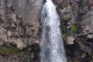
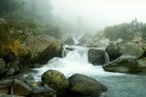
Taranaki Falls
Photograph
•
Distance: 10.0km away
These picturesque falls are located within easy walking distance of the Chateau Tongariro and are well worth visiting.
A harmless challenge ...
More ▶︎