Nearby
Okareka Tobins Hill to Miller Rd
Tikitapu Reserve Loop Track
Track
•
Easy. Loop track.
•
Distance: 2.2km away
Just a short walk with interpretation signs. Metaled surface added by yours truely and many others using wheelbarrows.
This would be ...
More ▶︎
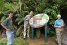
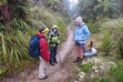
Sign at the Beginning of the Tikitapu Loop Track
Photograph
•
Distance: 2.2km away
These keen volunteers are posing immediately after erecting this sign at the beginning of the Tikitapu Loop Track
More ▶︎
Lake Tikitapu
Track
•
Easy. Loop track with a road section.
•
Distance: 2.5km away
A popular walk taking just over an hour. You will meet just about everyone from Rotorua who is walking their ...
More ▶︎
Around Lake Tikitapu
GPX file
•
Distance: 2.5km away
A popular walk taking just over an hour. You will meet just about everyone from Rotorua who is walking their ...
More ▶︎
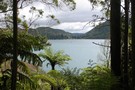
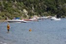
Lake Tikitapu
Photograph
•
Distance: 3.4km away
Also known as the Blue Lake, this picturesque lake just near Rotorua is popular for recreation
More ▶︎
Tarawera Trail
GPX file
•
Distance: 3.5km away
The first day of what will eventually be a three day trip around Lake tarawera
More ▶︎
Tarawera Trail
Track
•
Easy/medium. Return by the same track.
•
Distance: 4.0km away
The first day of what will eventually be a three day trip around Lake tarawera
More ▶︎
Eastern Okataina Walkway
Track
•
1 day. Easy.
•
Distance: 5.4km away
Take some good legs and enjoy the track. Fairly easy walk but some up and down but you don't really ...
More ▶︎
Okataina Ratas
GPX file
•
Distance: 6.0km away
The Okataina Ratas are probably the biggest in New Zealand. The tree called the Phantom has been measured with a ...
More ▶︎
Okataina Ratas
Track
•
1 day. Medium. Loop track.
•
Distance: 6.1km away
This is a challenging detour off the Eastern Okataina Walkway. It is mostly off track with only basic markers. Good ...
More ▶︎
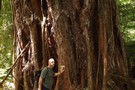
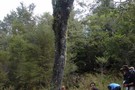
The Phantom
Photograph
•
Distance: 6.1km away
Probably New Zealand's biggest Northern Rata Tree. Measured with a trunk diameter of 4.5m
More ▶︎
Tracks around Okataina School Camp
GPX file
•
Distance: 7.3km away
Park your car at the school camp and there are walks that can keep you occupied for a half day ...
More ▶︎
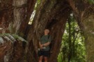
The Cathedral
Photograph
•
Distance: 7.4km away
This group of Rata root structures creates a series of arches somewhat like in a cathedral
More ▶︎
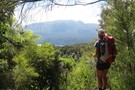
The track up Whakapoungakau
Photograph
•
Distance: 7.4km away
The track up Whakapoungakau is good, most of it following the course of the Western Okataina Walkway
More ▶︎
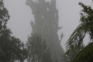
The old Rata Tree
Photograph
•
Distance: 7.4km away
This old rata stump is a landmark near the spot where the Whakapoungakau track turns off the Western Okataina Walkway
More ▶︎
The Lone Tawa
Photograph
•
Distance: 7.4km away
This Tawa sits in the middle of a small clearing which was once an old skid site. Just a nice ...
More ▶︎
Whakaupoungaku
Track
•
Easy. Return via same track.
•
Distance: 7.7km away
The summit of Whakapoungakau is just off the Western Okataina Walkway. The summit is a pleasant place, with grassy clearing ...
More ▶︎
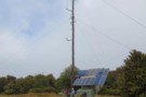
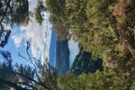
Whakaupoungaku Summit
Photograph
•
Distance: 7.7km away
The summit of Whakapoungakau is graced with this mast and a trig station. However it is a sunny grassy place ...
More ▶︎
Hot Water Beach
Photograph
•
Distance: 8.9km away
This is a very popular place to camp in the summer, and it isn't only trampers who camp here
More ▶︎
Rotorua
Place
•
Place. 2614.90km2.
•
Distance: 9.0km away
A resort town located on a geothermal area in the Bay of Plenty region of the North Island. The town ...
More ▶︎
Rotorua Tramping & Skiing Club
Club
•
Distance: 9.8km away
We are an active tramping club with trips most weekends. We also have a lodge on Mt Ruapehu and 2 ...
More ▶︎