Nearby
Waipakihi and Ruapehu
Tauranga-Taupo Falls - GPX
GPX file
•
Distance: 6.8km away
A GPX file of the trip to these magnificent falls. There are some multipath errors in this track around the ...
More ▶︎
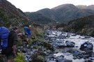
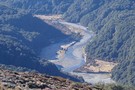
Sun on the water. Tauranga-Taupo River
Photograph
•
Distance: 6.9km away
The sun shining down into the gorge made for some interesting light patterns
More ▶︎

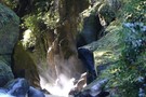
Slot Gorge above the Tauranga-Taupo Falls
Photograph
•
Distance: 6.9km away
This spectacular gorge is at the top of the Tauranga-Taupo Falls. There are several such gorges on the Tauranga-Taupo River ...
More ▶︎
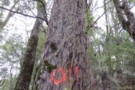
The O-Tree
Photograph
•
Distance: 7.1km away
A distinctively marked tree that is a landmark on the way to the Tauranga Taupo Falls
More ▶︎

You Mean I Have to Put Them Back On!!
Photograph
•
Distance: 7.1km away
Alternative caption:- After this sandwich, you're next
More ▶︎
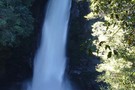
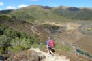
Tauranga-Taupo Falls
Photograph
•
Distance: 7.1km away
This waterfall is one of the more magnificent ones in the North Island and is rarely visited.
This photo is taken ...
More ▶︎
Tauranga-Taupo Falls
Track
•
1 day. Medium. Return via same track.
•
Distance: 7.1km away
The Tauranga-Taupo Falls would have to be one of the more spectacular falls in the North Island. The track in ...
More ▶︎
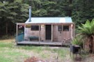
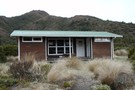
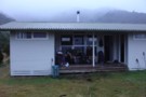
Cascade Hut Kaimanawa Forest Park
Photograph
•
Distance: 7.5km away
A standard ex-NZFS six-bunk hut that has been modified by interior lining, exterior cladding, verandah and deck and wood burner.
More ▶︎
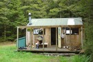
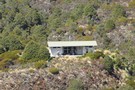
Cascade Hut
Photograph
•
Distance: 7.5km away
A great location in a clearing above the river
More ▶︎

A Corker Cooker, One of DOC's better ideas
Photograph
•
Distance: 7.5km away
Some nice person had carved pumice blocks to make a pizza oven out of this one.
More ▶︎
Cascade Hut
Hut
•
Standard Hut (DOC). Capacity: 6.
•
Distance: 7.5km away
A delightful 6 bunk hut in the upper reaches of the Tauranga Taupo River.
More ▶︎
Oamaru & Cascade Huts via the Kaipo - GPX
GPX file
•
Distance: 7.5km away
GPX file of a 3 day trip taking in Oamaru and Cascade Huts via the Kaipo Stream
More ▶︎
Oamaru to Cascade Hut via Maungaorangi GPX
GPX file
•
Distance: 7.5km away
A GPX file of the route from Oamaru Hut to Cascade Hut via Maungaorangi. This route avoids the private land ...
More ▶︎
Oamaru to Cascade Hut via Maungaorangi
Track
•
1 – 2 days. Medium. One way.
•
Distance: 7.5km away
An alternative route from Oamaru Hut to Cascade Hut
More ▶︎
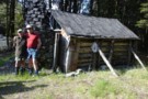
Stanfield's Whare
Photograph
•
Distance: 7.8km away
Stanfield's from the outside is very picturesque
More ▶︎
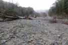
My how the landscape has changed
Photograph
•
Distance: 7.8km away
This is the exact spot where Stanfield's Whare was located. Not a sign of it now, the nearest bush is ...
More ▶︎

Stanfield's Whare (destroyed)
Hut
•
Removed!
•
Distance: 7.8km away
All gone - See related photo.
Was a historic hut on the banks of the Tauranga-Taupo just downstream of Cascade Hut. ...
More ▶︎
Stanfield's Whare
Photograph
•
Distance: 7.8km away
Despite the rustic nature of thus hut, Winston found this bunk to be quite comfortable
More ▶︎
Waipakihi Thunderbolt Loop
GPX file
•
Distance: 8.0km away
A 3 day loop in the Kaimanawas with a lot of enjoyable tops travel
More ▶︎
Urchin - Waipakihi Hut - Umukarikari - GPX
GPX file
•
Distance: 8.0km away
A GPX file of this classic trip
More ▶︎
Waipakihi Thunderbolt Loop
Track
•
3 days. Medium. Loop track with a road section.
•
Distance: 8.0km away
A 3 day trip in the Kaimanawas following the Middle Range and enjoyable tops tramping. Also a probable night camping ...
More ▶︎
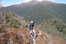
Aproaching Waipakihi Hut
Photograph
•
Distance: 8.0km away
It is a long haul up the Waipakihi River and you are wondering how long it will be, when suddenly ...
More ▶︎
Waipakihi Hut to Middle Range
Track
•
Medium. One way.
•
Distance: 8.0km away
DOC have re cut an old track that gives access to the Middle Range from Waipakihi Hut. The usual route ...
More ▶︎
Waipakihi Hut
Photograph
•
Distance: 8.0km away
A great hut in the heart of the Kaimanawa Ranges.
More ▶︎
Urchin - Waipakihi Hut - Umukarikari Trip
Track
•
2 – 3 days. Easy/medium. Loop track with a road section.
•
Distance: 8.0km away
A classic 2 - 3 day trip in the Kaimanawas. Includes open tops, river travel and a comfy hut for ...
More ▶︎

Waipakihi Hut
Photograph
•
Distance: 8.1km away
12 bunk hut in the kaimanawas on a bench above the river a pleasant place to spend a sunny day
More ▶︎
Waipakihi Hut
Photograph
•
Distance: 8.1km away
A telephoto shot of Waipakihi Hut as you approach it from Umukarikari
More ▶︎
Waipakihi Hut
Hut
•
Standard Hut (DOC). Capacity: 12.
•
Distance: 8.1km away
Very tidy hut situated on a bench above the Waipakihi River on a Sunny day this would be a great ...
More ▶︎
Above Waipakihi Hut
Photograph
•
Distance: 8.7km away
Looking down towards Waipakihi Hut from near the end of the Umukarikari Track.
More ▶︎
Kaimanawa Forest Park
Place
•
Conservation Park. 763.48km2.
•
Distance: 8.8km away
Mountain wilderness east of Tongariro National Park. Highest point: 1727m (Makorako).
More ▶︎
Email from doc Turangi re the East Taupo Lands Block
Article
•
Distance: 8.8km away
An email received from Terry Slee at DOC Turangi regarding their negotiations with the East Taupo Lands Trust regarding access
More ▶︎
Kaimanawa Forest Park - East Taupo Lands Trust Boundary
GPX file
•
Distance: 8.8km away
I like to have this track loaded into my GPS whenever I am in the Kaimanawas because the boundary is ...
More ▶︎
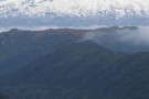
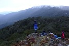
Mt Ruapehu with the Waipakihi River in the foreground
Photograph
•
Distance: 9.6km away
Ruapehu dominates the view from the western Kaimanawas
More ▶︎