Nearby
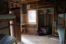
Tribulation Hut
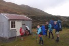
DOC-revamped Tribulation Hut
Photograph
•
Distance: less than 100m away
A 6 bunker,no fire,4 hrs from Double Hill Road t/r Rakaia River,at Redcliffe Stream.
More ▶︎
Redcliffe Stream
Track
•
1 – 2 days. Easy/medium. Return by the same track.
•
Distance: less than 100m away
Short walk to an old musterers' hut near the Hutt Range.
More ▶︎
Labour Weekend Traverse of Black Hill Range
Article
•
Distance: 2.5km away
3 day weekend traverse of retired pastoral lease in the upper Rakaia on the former Black Hill and Redcliffe runs. ...
More ▶︎
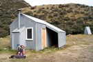
Cookies Hut
Hut
•
Standard Hut (DOC). Capacity: 6.
•
Distance: 3.6km away
Former musterers' hut oft used by hunters. Now owned and newly renovated by DoC as of Feb 2016.
More ▶︎
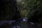
Comyns Cookies travels
Photograph
•
Distance: 3.6km away
Various routes around these huts and A-Frame hut.
More ▶︎
Hakatere Conservation Park
Place
•
Conservation Park. 600.00km2.
•
Distance: 5.7km away
This park protects high country between the Rakaia and Rangitata Rivers in the Ashburton Lakes District, Mid-Canterbury.
More ▶︎
4 Day Comyns, Cookies Huts circuit
Article
•
Distance: 6.1km away
Easter trip in 2018, involving a descent of the Nth Ashburton to Cookies Point and the hut and then north ...
More ▶︎
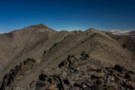
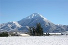
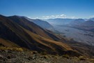
Steepface Hill Summit
Photograph
•
Distance: 6.6km away
Looking south toward Mount Hutt (2185m).
More ▶︎
Steepface Hill
Track
•
1 day. Medium. Return by the same track.
•
Distance: 6.6km away
A vigorous climb to a summit on the Mount Hutt Range. Spectacular views across the Rakaia River, Lake Coleridge, and ...
More ▶︎
Comyns Hut
Hut
•
Basic Hut/Bivvy (DOC). Capacity: 8.
•
Distance: 8.0km away
Corrugated iron hut on grassland next to Turtons Stream, south of Lake Coleridge. Constructed in 1957, restored in 2008, and ...
More ▶︎
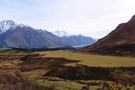
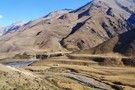
Rakaia Valley
Photograph
•
Distance: 8.3km away
Afternoon sun on Steepface Hill, beneath point 1488.
More ▶︎
Kowhai Flat
Campsite
•
Informal campsite (DOC).
•
Distance: 9.1km away
A basic campsite on the banks of the Rakaia River. This campsite is commonly used for fishing trips, but is ...
More ▶︎
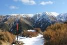
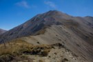
Scott's Saddle
Photograph
•
Distance: 9.2km away
Top of the Scott's Saddle Track on Mount Hutt, looking toward the Pudding Hill Range.
More ▶︎
Pudding Hill Stream Route
Track
•
1 day. Medium. One way.
•
Distance: 9.8km away
Unmarked route along Pudding Hill Stream in Mount Hutt Forest. Combine this route with the Scotts Saddle Track for an ...
More ▶︎