Nearby
Karamea Bend Hut
Leslie-Karamea
Track
•
3 – 4 days. Medium. One way.
•
Distance: less than 100m away
Joins onto Wangapeka Track.
More ▶︎
Mt Arthur to Murchison
GPX file
•
Distance: 1.1km away
track from Mt Atrhur Tablelands to Murchison via Wangapeka Saddle, Nugget Knob and the Matiri Valley
More ▶︎
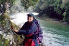
Leslie-Karamea Track
Photograph
•
Distance: 3.0km away
A moderate 7-9-day tramp thru the heart of Kahurangi National Park, for experienced trampers with good gear and skills.
More ▶︎
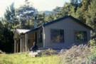
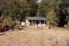
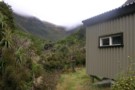
Karamea Bend Hut
Photograph
•
Distance: 3.0km away
Sited adjacent to the Leslie River, this big barn is harder to heat.
More ▶︎
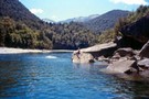
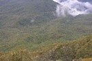
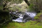
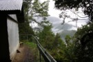
Karamea River
Photograph
•
Distance: 3.0km away
The legendary Karamea flows north, then suddenly turns west out to sea, (through grade 5 whitewater & a notorious gorge). ...
More ▶︎
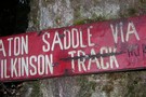
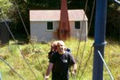
Wilkinson Track sign
Photograph
•
Distance: 3.8km away
At the bottom of the track, this sign remembers conditions from several years ago – DOC cleared the track in ...
More ▶︎
Wilkinson Track
Track
•
1 day. Medium. One way.
•
Distance: 3.8km away
Cleared by DoC in November 2011, the lower third of the track is now easily climbed. Above this, the track ...
More ▶︎
at the top of Wilkinson Track
Photograph
•
Distance: 6.0km away
above the tree-line, Wilkinson Track requires a push through Spaniard grass followed by a steep climb to Baton saddle – ...
More ▶︎
Baton Valley Track
Track
•
Easy/medium. One way.
•
Distance: 6.1km away
From Baton Saddle, the route follows snow-poles steeply down to the valley floor through Spaniard grass thickets (not the most ...
More ▶︎
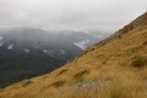
Baton Saddle
Photograph
•
Distance: 6.1km away
from Baton Saddle, looking N across the top of Wilkinson’s Track into the Leslie Valley – Apr 2011
More ▶︎
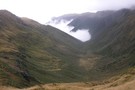
Baton Valley
Photograph
•
Distance: 6.1km away
looking S from Baton Saddle, Flanagan’s Hut is on the edge of the valley cloud, a very steep descent and ...
More ▶︎
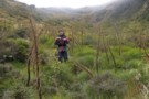
Descent from Baton Saddle
Photograph
•
Distance: 6.3km away
following the pole-line from Baton Saddle doesn’t avoid the Spaniard grass ! – Apr 2011
More ▶︎
Tasman Wilderness Area
Place
•
Wilderness Area. 869.47km2.
•
Distance: 7.1km away
Region of undeveloped remote wilderness in Kahurangi National Park, stretching from the Garibaldi Ridge to the Heaphy River.
More ▶︎
Crow Hut (Kahurangi)
Hut
•
Standard Hut (DOC). Capacity: 12.
•
Distance: 7.5km away
Tucked away on a terrace at the confluence of Crow River and the mighty Karamea River.
More ▶︎
Crow Hut, Karamea River
Photograph
•
Distance: 7.6km away
Miners once fossicked for gold up the Crow River. Nowadays, Crow Hut sits as a silent sentinel of a bygone ...
More ▶︎
Roaring Lion Hut
Hut
•
Basic Hut/Bivvy (DOC). Capacity: 5.
•
Distance: 7.7km away
Roaring Lion hut
More ▶︎
Flanagans Hut
Hut
•
Standard Hut (DOC). Capacity: 8.
•
Distance: 7.9km away
a very pleasant 8-bunk hut – no water tank but the Baton stream is 20m from the door – Apr ...
More ▶︎
Baton Stream
Photograph
•
Distance: 7.9km away
the water supply for Flanagan’s Hut – Apr 2011
More ▶︎
Flanagans Hut
Photograph
•
Distance: 7.9km away
taken from beside the Baton Stream, Flanagan's Hut is a welcome respite after a descent from Baton Saddle - Apr ...
More ▶︎
Baton Saddle from Flanagan’s Hut
Photograph
•
Distance: 7.9km away
Mist closing in on the saddle – Apr 2011
More ▶︎
Spludgeon Shelter
Photograph
•
Distance: 9.0km away
front of the shelter, with view into the Leslie River - Apr 2011
More ▶︎
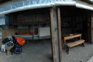
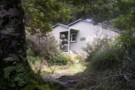
Splugeons Rock Shelter
Hut
•
Basic Hut/Bivvy (DOC). Capacity: 5.
•
Distance: 9.0km away
A great hut built into a natural rock shelter. Water available from a nearby stream.
More ▶︎
Spludgeons Shelter
Photograph
•
Distance: 9.0km away
Capacity 5 - earthen floor, heavy plastic roll-up for main wall (lashed down when this photo taken - Apr 2011)
More ▶︎