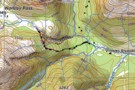
Nearby
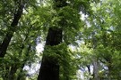
East Hawdon Stream
East Hawdon Stream
Track
•
1 – 2 days. Easy/medium. Return via same track.
•
Distance: 1.9km away
A short walk to a new biv located on a branch of the Hawdon River.
More ▶︎
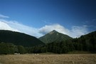
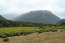
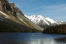
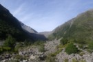
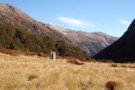
Hawdon Valley - Discovery Flat
Photograph
•
Distance: 2.0km away
View looking to the south across the Hawdon Valley at Discovery Flat. Taken from the track up from the Hawdon ...
More ▶︎
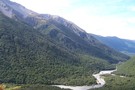
Hawdon River
Track
•
2 days. Easy. Return via same track.
•
Distance: 2.0km away
Easy travel up a wide river valley.
More ▶︎
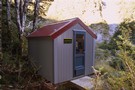
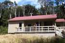
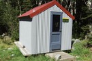
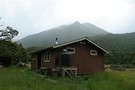
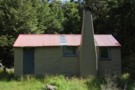
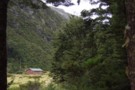
East Hawdon Biv
Photograph
•
Distance: 3.1km away
The shiny new two-bunk hut in the frosty East Hawdon Valley.
More ▶︎
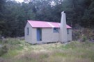
East Hawdon Bivouac
Hut
•
Basic Hut/Bivvy (DOC). Capacity: 2.
•
Distance: 3.2km away
A smart new hut on East Hawdon Stream. It was built 2007, replacing the original biv.
More ▶︎

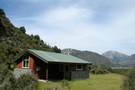
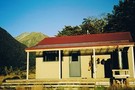
Hawdon Hut
Hut
•
Serviced Hut (DOC). Capacity: 20.
•
Distance: 3.3km away
A new hut opened in December 2007 after the previous hut was destroyed by fire June 2005.
An easy two to ...
More ▶︎
Sidle Mt Valiant
Photograph
•
Distance: 3.3km away
A good direct route from the East Hawdon to the head of the Poulter at Trudge stream, Arthurs Pass National ...
More ▶︎
Woolshed Hill
Track
•
Medium. Hawdon Valley.
•
Distance: 4.3km away
The track begins steeply climbing through beech forest from near the Hawdon carpark. It emerges into brilliant dracophyllum draped tops ...
More ▶︎

The Descent Route of the NW Tributary of Discovery Stream
Photograph
•
Distance: 4.4km away
this route avoids waterfalls
More ▶︎
Descent Route from NW Tributary of Discovery Stream
Photograph
•
Distance: 4.4km away
This avoids waterfalls
More ▶︎

Casey Saddle - Poulter River - Binser Saddle
Track
•
2 – 3 days. Easy/medium. Loop track with a short road section.
•
Distance: 4.4km away
A brief circuit crossing one open saddle and one bush saddle in the southeastern corner of Arthur's Pass National Park. ...
More ▶︎
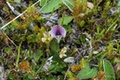
Carmichaelia monroi
Photograph
•
Distance: 4.4km away
A tiny dwarf broom growing north of Hallelujah Flat, Andrews Track, Arthur's Pass National Park.
More ▶︎
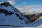
Approaching Casey Saddle
Photograph
•
Distance: 4.5km away
Casey Saddle (777m) is a flat, barely perceptible saddle. Castle Hill (1545m) is behind.
More ▶︎
Discovery Stream/Sudden Valley traverse
Article
•
Distance: 5.0km away
2 day circuit from Hawden River, crossing mountain ridgetop after approach from Discovery Stream which features boulder-hopping and cascades.
More ▶︎
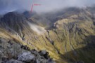
trudge col
Photograph
•
Distance: 5.3km away
trudge col as seen from hawdon hut. left of rough peak, hawdon valley, arthurs pass national park.
More ▶︎
trudge col - from the north
Photograph
•
Distance: 5.4km away
Trudge stream drains the northern or Poulter side of Trudge Col. Crossing Trudge Col provides an interesting and challenging route ...
More ▶︎
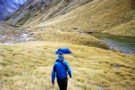
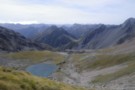
Walker Pass Tarn
Photograph
•
Distance: 5.4km away
October 08,
Tarn on Walker Pass looking back towards the Hawdon Valley
More ▶︎
Sudden Valley
Article
•
Distance: 5.5km away
Sudden Valley off Hawdon Valley - Arthurs Pass
Great short trip in times of low rainfall
More ▶︎
"New" Sudden Valley biv Feb 2010
Photograph
•
Distance: 5.5km away
Replacement for old biv. This biv is only a short distance from the Hawdon Shelter. You can get in and ...
More ▶︎
Sudden Valley Biv
Hut
•
Basic Hut/Bivvy (DOC). Capacity: 2.
•
Distance: 5.5km away
The small dark biv was replaced Summer 2008. Camping is possible around the biv.
More ▶︎
Sudden Valley
Track
•
2 days. Medium. Return via same track.
•
Distance: 5.5km away
A secluded hanging valley in the southeast corner of Arthur's Pass National Park
More ▶︎

Edwards River-Hawdon River
Track
•
3 days. Medium. One way.
•
Distance: 5.7km away
See Hawdon River.
More ▶︎
Sudden valley track
Article
•
Distance: 5.7km away
Comments to add to other articles about Sudden Valley
More ▶︎
Otehake Hut
Hut
•
Standard Hut (DOC).
•
Distance: 6.1km away
Otehake Hut. NZFS six bunker with porch. Built 1962/63.
More ▶︎
Towards Andrews and Binser
Photograph
•
Distance: 6.1km away
Taken end of Summer '06 on a brief jaunt between Hawdon and Andrews stream, nearby is a grove of gooseberries ...
More ▶︎
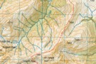
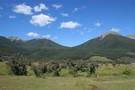
Arthur's Pass National Park
Place
•
National Park. 1145.00km2.
•
Distance: 6.1km away
This alpine park straddles the Main Divide of the Southern Alps, with dry beech forests in the east and damp ...
More ▶︎
Edwards River-Otehake River
Track
•
4 days. Medium. One way.
•
Distance: 6.1km away
Another north-south crossing of the park.
More ▶︎
Circuit from Binser Saddle to Hallelujah Flat
Article
•
Distance: 6.4km away
Overnight camp on Binser Saddle followed by 9 hour circuit along tops north of saddle and down to Hallelujah Flats, ...
More ▶︎
Red beech forest
Photograph
•
Distance: 6.4km away
Red beech occupies some of the flat terrace above Andrews Stream, Andrews Track, Arthur's Pass National Park.
More ▶︎
Veiw from campsite on Amber Col
Photograph
•
Distance: 6.5km away
This just shows the route up to Amber Col from the Otehaki river on the bottom right, Falling Mtn on ...
More ▶︎

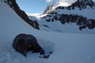
First Light Amber Col
Photograph
•
Distance: 6.5km away
5:30am God it's early, beautiful light, freezing cold, about an hour before total white-out.
More ▶︎
Amber Col
Photograph
•
Distance: 6.5km away
September 2008
Stayed the previous night at the new Hawdon Hut, then made my way over Walker Pass and up the ...
More ▶︎
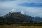
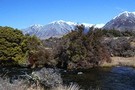
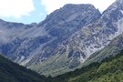
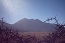
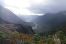
Horrible and Misery
Photograph
•
Distance: 6.8km away
Mounts Horrible (1234m) and Mount Misery (1765m) from the Hawdon River flats.
More ▶︎
Hawdon Shelter campsite
Campsite
•
Informal campsite (DOC). 20 spaces.
•
Distance: 6.9km away
Broad golden grass flats on the banks of the Hawdon River. Kea overhead and ample space to avoid the crowds. ...
More ▶︎
Hawdon Shelter
Hut
•
Shelter (DOC).
•
Distance: 6.9km away
An open shelter at the edge of extensive frost flats. Ample camping opportunities.
More ▶︎
Casey/Castle Hill Return
Article
•
Distance: 6.9km away
A weekend trip with the Peninsula Tramping Club where we ascended to Castle Hill from the Surprise/Casey Stream junction and ...
More ▶︎
Hawdon River flats
Photograph
•
Distance: 6.9km away
Ample camping space around the Hawdon Shelter across the Mount White Bridge. The Pyramid (1608m) is in the background.
More ▶︎
Caterpillar on bog pine
Photograph
•
Distance: 7.0km away
This Dasyuris callicrena caterpillar is brilliantly disguised and almost invisible. It is directly in the centre of this picture. Dracophyllum ...
More ▶︎
Penny Pass
Track
•
3 – 4 days. Medium. Loop track.
•
Distance: 7.6km away
3 day trip from upper Poulter River over Penny Pass between Minchin and Thompson Streams.
More ▶︎
Heading back to the tent on Tarn Col
Photograph
•
Distance: 7.7km away
Chuzzman aka chuzz returning to the tent after getting yha on the cliff-sides of Tarn Col.
More ▶︎
Andrews Stream-Lake Minchin-Townsend Creek
Track
•
4 days. Medium. One way.
•
Distance: 7.7km away
A north-south crossing of the park.
More ▶︎
Andrews Shelter
Photograph
•
Distance: 7.7km away
An enclosed shelter at the beginning of the Andrews Track leading to Casey Saddle.
More ▶︎
Andrews Shelter
Hut
•
Shelter (DOC).
•
Distance: 7.7km away
Shelter and campsite on Andrews Stream near the Mount White Bridge. Water is available from the nearby stream. Here, or ...
More ▶︎
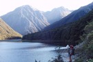
Lake Minchin
Photograph
•
Distance: 7.7km away
Not far from the new Poulter Hut, though the old Trust Poulter Hut has more 'character' and is quite liveable. ...
More ▶︎
Andrews Shelter campsite
Campsite
•
Informal campsite (DOC). 20 spaces.
•
Distance: 7.7km away
Free camping on flats next to Andrews Stream. A sturdy shelter is located here. From here, the Andrews Valley Track ...
More ▶︎
NZFS track to Worsley Pass and deer trail route in Poulter Gorge
Photograph
•
Distance: 8.5km away
They were bitchin' in the hut book about this track in 1988. No work done on it for a long ...
More ▶︎
Worsley Biv
Hut
•
Basic Hut/Bivvy (DOC). Capacity: 3.
•
Distance: 8.6km away
Recently renovated (thanks CUTC with Kerry Clapham) with new ridgeline and skylight 'A' frame Maori bunk biv, with 3 foam ...
More ▶︎
Ascent to Taruahuna Pass
Photograph
•
Distance: 8.6km away
Ascent to Taruahuna Pass from Otehake
More ▶︎
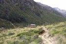
Casey Hut
Photograph
•
Distance: 8.7km away
A comfortable but prosaic hut in the Poulter Valley, Arthur's Pass National Park.
More ▶︎
Casey Hut [DESTROYED]
Hut
•
Removed!
•
Distance: 8.7km away
This hut burned down around 3 October 2015. and has been replaced by a 12 person hut 15 minutes further ...
More ▶︎
The Recutting of the NZFS track to Worsley Pass
Article
•
Distance: 8.7km away
How we searched for, found, recut and marked this ancient track that had been lost for 25 years.
More ▶︎

Herbfields above Worsley Pass
Photograph
•
Distance: 8.8km away
Herbfields above Worsley Pass
More ▶︎
Back down the Poulter from Worsley Pass
Photograph
•
Distance: 8.9km away
Back down the Poulter from Worsley Pass
More ▶︎
Otehake hut
Photograph
•
Distance: 9.0km away
Otehake hut is an NZFS six bunker that was built in 1963. It is the "stretched style" with a porch ...
More ▶︎
Otehake Hut
Photograph
•
Distance: 9.0km away
6 bunk NZFS style hut in the Otehake Valley, near the confluence of East & West Otehake Rivers, altitude 640m
More ▶︎
New Casey Hut
Hut
•
Standard Hut (DOC). Capacity: 12.
•
Distance: 9.3km away
Similar to Poulter Hut but has solar lighting and outside sink and bench on the porch under effective shelter. Nice ...
More ▶︎
Poulter Hut
Hut
•
Standard Hut (DOC). Capacity: 10.
•
Distance: 9.3km away
Fairly new hut with 8 mattresses on 2 levels of Maori bunks. On flats by the Poulter River at the ...
More ▶︎
Poulter Hut
Photograph
•
Distance: 9.3km away
At the confluence of Poulter River and Minchin Stream, Arthurs Pass NP
More ▶︎
Lake Anti-Mavis, Tarn Pass in the distance
Photograph
•
Distance: 9.7km away
Lake Anti-Mavis, Tarn Pass in the distance
More ▶︎
Edwards Hut Toilet
Photograph
•
Distance: 9.7km away
View down the valley from the Edwards hut.
More ▶︎
Edwards Hut
Hut
•
Serviced Hut (DOC). Capacity: 16.
•
Distance: 9.7km away
Well built hut, sleeps 16 people.
More ▶︎