Nearby
Louper Bivouac

Route Guide: Otira to Mt Cook Village (pt 2)
Track
•
12 – 21 days. Hard. One way.
•
Distance: less than 100m away
One possible route down the main divide from Otira on the Arthur's Pass road to Mt Cook Village.
Otira Hotel ...
More ▶︎
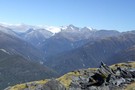
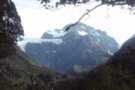
Mount Butler
Photograph
•
Distance: less than 100m away
Mount Butler from the Raikaia near Louper Biv / Reischek Hut
More ▶︎

Route Guide: Otira to Mt Cook Village (pt 1)
Track
•
12 – 21 days. Hard. One way.
•
Distance: less than 100m away
One possible route down the main divide from Otira on the Arthur's Pass road to Mt Cook Village.
Otira Hotel to ...
More ▶︎
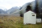
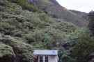
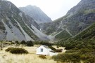
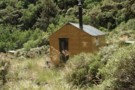
Louper Bivouac
Photograph
•
Distance: less than 100m away
Louper Bivvy in the Raikai below the Whitcombe Pass
More ▶︎
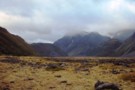
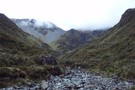
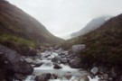
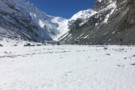
Raikaia River flats
Photograph
•
Distance: less than 100m away
Raikaia River flats between Louper Biv and Reischek hut
More ▶︎
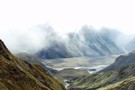
Whitcombe Pass
Track
•
5 – 7 days. Medium/hard. One way.
•
Distance: 156m away
This route follows the famous journey by John Henry Whitcombe and the Swiss guide Jakob Lauper across the Main Divide ...
More ▶︎
Picton to Aspiring
GPX file
•
Distance: 1.3km away
An aborted alpine traverse. Picton to West Cape, but aborted at Aspiring due to real world emergencies back home. Posted ...
More ▶︎
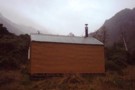
Reischek Hut
Photograph
•
Distance: 1.3km away
Reischek Hut, in the Raikaia valley below Butler Saddle.
More ▶︎
Reischek Hut
Hut
•
Basic Hut/Bivvy (NZDA). Capacity: 6.
•
Distance: 1.3km away
Reischek Hut (6-bunk, mattresses, stove, firewood, tank water, mountain radio) is a New Zealand Deer Stalkers Association (NZDA) hut on ...
More ▶︎
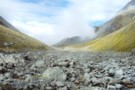
Butler Saddle
Photograph
•
Distance: 4.2km away
Butler Saddle from Reischek Stream. The saddle is the scree-covered col to the left of the ridge in the centre.
More ▶︎
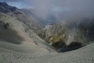
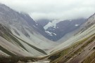
Whitcombe Pass
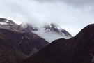
Photograph
•
Distance: 5.2km away
Whitcombe Pass - between the Whitcombe and Raikaia catchments. The Louper Stream descends 7km from this point to the flats ...
More ▶︎
Whitcombe Pass & Butler Saddle
Article
•
Distance: 5.3km away
route guide attached by for Hokitika Gorge to Erewhon via Whitcombe Pass & Butler Saddle. The guide was written by ...
More ▶︎
Evans Hut
Hut
•
Basic Hut/Bivvy (NZDA). Capacity: 6.
•
Distance: 5.4km away
Hut located at Cattle Stream on the Rakaia River.
More ▶︎
Lyell Hut
Hut
•
Club hut (Canterbury Mountaineering Club). Capacity: 8.
•
Distance: 5.7km away
This hut is located high on the Rakaia River near the foot of the Lyell Glacier.
More ▶︎
packrafting trip from upper Rakia to Erewhon Station
Video
•
Distance: 5.8km away
Climbing over Butler Saddle and packrafting down Lawrrence and Clyde Rivers to Erwehon Station in December 2008
More ▶︎
Butler Saddle and the Lawrence Valley
Photograph
•
Distance: 5.9km away
The view down the Lawrence Valley from Butler Saddle. This is an alpine route from The Raikaia into the Lawrence, ...
More ▶︎
Raikaia from the Butler Saddle
Photograph
•
Distance: 5.9km away
Raikaia River flats, from the Butler Saddle. This is an alpine route from the Raikaia to the Lawrence / Clyde ...
More ▶︎
Packrafting trip from Bealey to upper Rakaia River
Video
•
Distance: 6.2km away
A video of a hiking and packrafting trip up over Jordan saddle, down the Avoca, Harper, and Wilberforce Rivers, then ...
More ▶︎
Waimakariri to Rakaia
Video
•
Distance: 6.2km away
Video showing hike up the Waimakariri, over Jordan Pass, with a packraft down the Avoca and then walking up Rakaia ...
More ▶︎
Bruce Banfield Memorial Hut
Hut
•
Standard Hut (Canterbury Mountaineering Club). Capacity: 6.
•
Distance: 8.1km away
First built in 1946 in the Jagged Stream basin as a memorial to Bruce Banfield who died below White Col. ...
More ▶︎
Cameron Glacier
Photograph
•
Distance: 9.1km away
Cameron Glacier, Arrowsmith Range. taken March 2008.
More ▶︎
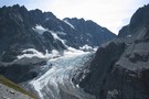
Boulder Col from Washbourne Ck to Jagged Stream
Article
•
Distance: 9.1km away
Nine hour circuit with good view of Reishek Glacier.
More ▶︎
Upper Whitcombe River at Neave Hut
Photograph
•
Distance: 9.6km away
The upper Whitcombe River at Neave Hut, just 5km from its headwaters at the Whitcombe Pass. The track to the ...
More ▶︎
Lawrence Bivouac
Photograph
•
Distance: 9.8km away
Lawrence Bivouac, a small 2-man biv in the upper Lawrence River, Canterbury. The falls at Hells Gates are visible behind.
More ▶︎
Upper Lawrence Valley
Photograph
•
Distance: 9.8km away
The upper Lawrence Valley and the Lawrence Glacier, from Lawrence Biv.
More ▶︎
Lawrence Bivouac
Hut
•
Basic Hut/Bivvy (DOC). Capacity: 2.
•
Distance: 9.8km away
Lawrence Bivouac (sleeps 2 on floor, matresses, stream water) is a small but weatherproof bivouac in the upper Lawrence Valley. ...
More ▶︎

Cameron upper valley
Photograph
•
Distance: 9.8km away
The upper Cameron valley showing the Cameron glacier and Arrowsmith range. taken March 2008.
More ▶︎
Neave Hut
Hut
•
Standard Hut (DOC). Capacity: 6.
•
Distance: 9.9km away
Neave Hut (6 bunks, matresses, stream water, stove, limited firewood) is a comfortable forestry-style hut in the upper Whitcombe Valley, ...
More ▶︎
Neave Hut
Photograph
•
Distance: 9.9km away
Neave Hut, in the upper Whitcombe, Westland. The hut lies just 5km below the Whitcombe Pass intot he Raikaia.
More ▶︎
Mount Evans
Photograph
•
Distance: 9.9km away
Mt Evans, from Neave Hut in the upper Whitcombe Valley of Westland.
More ▶︎