Nearby
upper anini campsite
Anini-Ruakituri Junction
Photograph
•
Distance: less than 100m away
This place is crawling with trout. Pity it's two big days walk from anywhere.
More ▶︎
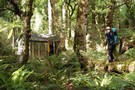
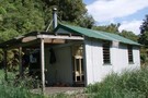
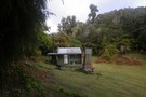
Tui Flat Hut
Hut
•
Basic Hut/Bivvy (NA). Capacity: 2.
•
Distance: 2.3km away
Unofficial but kind-of-official hut in the Ruakituri Wilderness Area, Te Urewera. Has a hut book, axe, billys, fireplace, a history ...
More ▶︎
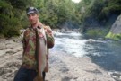
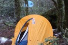
Anini clearing fly camp
Photograph
•
Distance: 2.5km away
Fly camp at the anini clearing, trout and venison for tea!
More ▶︎
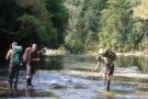
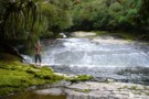
Ruakituri River Crossing
Photograph
•
Distance: 2.6km away
The Upper Ruakituri meanders over tilted papa slabs, allowing wide, shallow but very slippery crossings.
More ▶︎
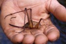
Whopper Cave Weta
Photograph
•
Distance: 2.6km away
This one was on a river bank, she got a fright and jumped into the water so we rescued her.
More ▶︎
A Waioeka - Urewera crossing: Redpaths Road to SH38
Track
•
4 – 7 days. Medium. One way.
•
Distance: 4.5km away
Continuing my traverse of the North Island's Main Range, this trip crosses the Waioeka Conservation and (former) Urewera National Park, ...
More ▶︎
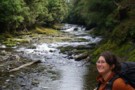
Upper upper Ruakituri
Photograph
•
Distance: 4.8km away
Anne Marie just above where the Ruakituri disappears underground.
More ▶︎
Five Day Trip in the Ureweras
GPX file
•
Distance: 5.0km away
A GPX file of a 5 day loop walk in the Ureweras
More ▶︎
Inside Te Rangaakapu Hut
Photograph
•
Distance: 5.0km away
Three bunks, a large bench and a kent fire built into a little alcove. There is lots of firewood around ...
More ▶︎
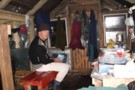
Te Rangaakapu Hut
Photograph
•
Distance: 5.0km away
A magnificent place to be, or is it the state you are in when you get there? A welcome site ...
More ▶︎
Te Rangaakapua Hut
Hut
•
Basic Hut/Bivvy (DOC). Capacity: 3.
•
Distance: 5.0km away
Just about as far as you can go in the Ureweras. I have heard this place described as one of ...
More ▶︎
A 5 day loop in the Ureweras
Track
•
5 – 7 days. Medium. Loop track.
•
Distance: 5.0km away
Wet rocky streams, long hauls over bush ridges on overgrown tracks, not much in the way of open tops. It ...
More ▶︎
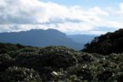
View SE from Te Rangaakapua
Photograph
•
Distance: 5.1km away
View SE from Te Rangaakapua hut, looking at point 1368 which is part of Maungapohatu. taken Feb 2010
More ▶︎
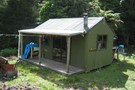
Mangatoatoa Hut
Hut
•
Standard Hut (DOC). Capacity: 8.
•
Distance: 5.9km away
A pleasant well maintained hut in a clearing high up on the Tauranga River. On the track from Makomako which ...
More ▶︎
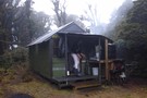
Mangatoatoa Hut
Photograph
•
Distance: 5.9km away
Mangatoatoa hut. Picture taken 6-Feb-2010.
More ▶︎
Ruakituri Wilderness Area
Place
•
Place. 235.50km2.
•
Distance: 7.3km away
Wilderness area located on the Huiarau Range in Te Urewera.
More ▶︎
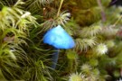
Blue Mushroom
Photograph
•
Distance: 7.3km away
There are a few of these pretty blue fungi in the Ureweras. Man they taste good!
More ▶︎
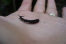
Peripatus
Photograph
•
Distance: 7.3km away
Found this cool peripatus in a rotten log in the Kopuapounamu basin, upper Ruakituri catchment, Ureweras.
More ▶︎
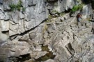
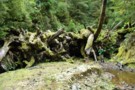
Ruakituri Sump Gorge
Photograph
•
Distance: 7.3km away
Most of the upper ruakituri river disappears underground, leaving a trickle to vanish down a deep jagged limestone gorge.
More ▶︎
Pool in the Kopuapounamu Stream
Photograph
•
Distance: 7.3km away
We camped next to this pretty pool in the Kopuapounamu stream, upper Ruakituri catchment.
More ▶︎
Makomako Hut
Hut
•
Standard Hut (DOC). Capacity: 8.
•
Distance: 8.1km away
A surprisingly tidy hut at the intersection of Six Foot Track and the track to Mangatoatoa. Like most Uruwera huts, ...
More ▶︎
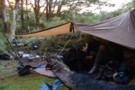
Good Camping on the track
Photograph
•
Distance: 8.2km away
There is a good campsite where the track comes down to the Kaipo lagoons from Pukepuke
More ▶︎
Manuoha - Waikareiti Circut
Track
•
3 days. Easy/medium. Loop track with a road section.
•
Distance: 8.2km away
A three day circut in Urewera National Park. Mt Manuoha is the highest point in the Park and offers great ...
More ▶︎
A Waioeka - Urewera Tarverse
GPX file
•
Distance: 8.3km away
A trip shadowing the main divide through the Waioeka Conservation Area and Urewera National Park.
See related track for a route ...
More ▶︎
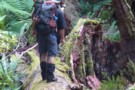
Navigating in the Bush
Photograph
•
Distance: 9.3km away
Trying to get where you're going in untracked bush full of windfalls from last years snow storm requires lots of ...
More ▶︎