Nearby
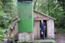
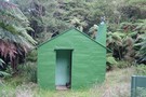
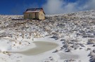
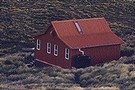
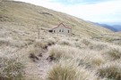
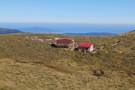
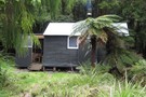
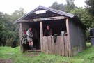
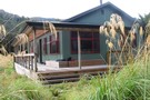
Tutuwai Hut
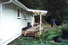
Tutuwai Hut
Hut
•
Serviced Hut (DOC). Capacity: 20.
•
Distance: less than 100m away
Set on a bank above a river flat (good camping). Gas stoves and running water. Potbelly stove. Well-built modern hut.
More ▶︎
Kaitoke to Greytown via Tutuwai & Mt.Reeves, Tararua Forest Park
Article
•
Distance: less than 100m away
A two day jaunt to clear the head and get a little much needed exercise. Oh and to enjoy some ...
More ▶︎
A Total Tararua Traverse
Track
•
8 – 16 days. Medium. One way.
•
Distance: less than 100m away
The length of the Tararuas via the pointy bits, from the Manawatu Gorge at Woodville to the Rimutaka Hill Road ...
More ▶︎
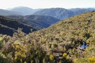
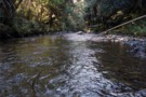
Waiohine River Valler Reeves Track End
Photograph
•
Distance: 1.2km away
Waiohine River Valler Reeves Track End
More ▶︎
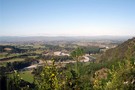
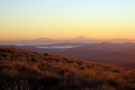
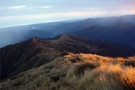
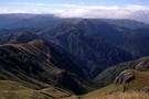
Northern Wairarapa from Mt Reeves Track
Photograph
•
Distance: 1.2km away
Northern Wairarapa from Mt Reeves Track
More ▶︎
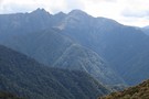
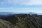
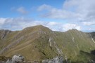
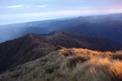
Tararua Peaks from Mt.Reeves
Photograph
•
Distance: 1.2km away
In the far distance you can just make out the Tararua Peaks from Mt Reeves. The Tauherenikau Valley is in ...
More ▶︎
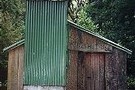
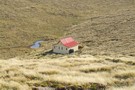
Cone Hut
Hut
•
Basic Hut/Bivvy (DOC). Capacity: 12.
•
Distance: 3.0km away
An outstanding example of bush carpentry. Built in 1946, renovated using original techniques in 1987. Adzed totara plank sleeping platform, ...
More ▶︎
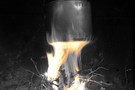
A billy at Cone Hut
Photograph
•
Distance: 3.0km away
We passed through Cone Hut at about morning tea time, which was really just an excuse to build a small ...
More ▶︎
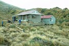
Alpha Hut
Hut
•
Standard Hut (DOC). Capacity: 16.
•
Distance: 4.5km away
The first Alpha Hut was built in 1915, the 2nd replaced it in 1953 ( it was 6 yards inside ...
More ▶︎
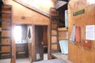
Eastern Hut Hut
Hut
•
Private hut (NA). Capacity: 6.
•
Distance: 5.4km away
Hut operated by the Greater Wellington Regional Council.
Although it is said to be for emergency use only, the 6 bunks ...
More ▶︎
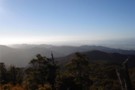
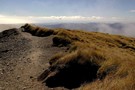
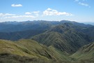
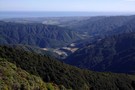
Mt Reeves Track
Photograph
•
Distance: 5.8km away
The track never goes above the treeline but into the subalpine zone which affords great views of the Wairarapa Plains.
More ▶︎
Maungahuka and the Tararua Peaks from Cone
Photograph
•
Distance: 5.9km away
Maungahuka and the Tararua Peaks from Cone
More ▶︎

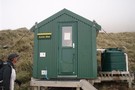
Smith Creek Shelter
Hut
•
Shelter (DOC).
•
Distance: 6.3km away
A small concrete block shelter on Smith Creek at the end of the descent from Puffer Saddle for those crossing ...
More ▶︎

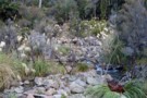
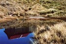
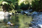
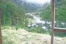
Feeder Creek Tauherenikau Valley nr Tutuwai Hut
Photograph
•
Distance: 6.5km away
Feeder Creek Tauherenikau Valley nr Tutuwai Hut - the track crosses an open expanse of rocky river bed for a ...
More ▶︎
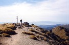
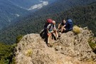
Mount Reeves Track
Track
•
1 day. Easy/medium. Return by the same track.
•
Distance: 6.5km away
Mt. Reeves is a nice little peak on the eastern side of the Tararua ranges. There are good views over ...
More ▶︎
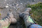
Working Boots
Photograph
•
Distance: 6.7km away
My boots and rainbow leggings - 2 days into Southern Crossing of Tararua Range
More ▶︎
Winchcombe Bivvy No. 3
Photograph
•
Distance: 6.8km away
From Hutbagger.co.nz "This was built by ex NZFS culler Paul Gush at his home and in April 2021, it was ...
More ▶︎
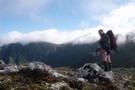
Southern Crossing Tararuas
Photograph
•
Distance: 6.8km away
Leaving Aston the ruas didnt disappoint fine in the morning high winds and clag around lunch and fine by the ...
More ▶︎
Mt. Hector
Photograph
•
Distance: 7.0km away
Looking across the Tararua main range from Mt. Hector to Alpha Hut.
More ▶︎
Mt. Hector
Photograph
•
Distance: 7.0km away
Looking across the Tararua main range from Mt. Hector to Alpha Hut. November 2007
More ▶︎
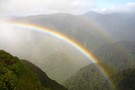
Rainbow under Neill Peak
Photograph
•
Distance: 7.0km away
We were chasing rainbows all morning.
More ▶︎
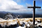
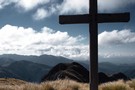
Memorial Cross on Mt Hector September 2012
Photograph
•
Distance: 7.4km away
Memorial Cross on Mt Hector, Tararua Range, looking north east down the Niell Ridge with Winchcombe peak in the distance
More ▶︎
Mount Hector
Photograph
•
Distance: 7.4km away
Photo taken facing the west coast towards Otaki from the summit of Mount Hector.
More ▶︎
Mt Hector Memorial Cross
Photograph
•
Distance: 7.4km away
View looking towards Winchcombe Peak from Mt Hector in April 2008 during a perfect 3 day Southern Crossing with not ...
More ▶︎
Mt Hector from Fields Peak
Photograph
•
Distance: 7.4km away
View of Mt Hector and surrounds from Fields Peak.
More ▶︎
Mount Hector
Photograph
•
Distance: 8.3km away
Memorial Cross on the summit of Mount Hector. Lake Wairarapa in the background and The Beehives on the right. Great ...
More ▶︎
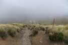
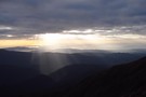
Descent to Kime Hut...
Photograph
•
Distance: 8.6km away
12 March 2011 - Nice day but the tops were a bit cloudy (funny that!)
More ▶︎
Wellington and Kaikoura peaks from Kime
Photograph
•
Distance: 8.6km away
Wellington and Kaikaoura peaks from near Kime hut. taken Feb 2009.
More ▶︎
Kime in mid summer
Photograph
•
Distance: 8.7km away
On a calm sunny day there is no better place
More ▶︎
Kime Hut
Photograph
•
Distance: 8.7km away
Kime Hut, Tararua Range near Mt Hector August 2010. One of the coldest huts in the Tararua's
More ▶︎
Kime Hut
Photograph
•
Distance: 8.7km away
The highest hut on the Southern Crossing (1400m). Magnificent views north and south. Handy for Mt. Hector. No stove - ...
More ▶︎
Kime Hut
Hut
•
Standard Hut (DOC). Capacity: 20.
•
Distance: 8.7km away
The highest hut on the Southern Crossing. Nice view of Masterton through the valley. This hut was replaced in 2014 ...
More ▶︎
Kime Hut - Tararuas
Photograph
•
Distance: 8.7km away
Kime Hut November 2007 on a jaunt to Mt.Hector for the weekend.
More ▶︎
Tararua main ridge
Track
•
4 – 8 days. Medium. One way.
•
Distance: 8.7km away
The length of the tracked Tararuas along the main ridge from Mangahao (behind Shannon) to Kaitoke.
For a 'Total Tararua Traverse ...
More ▶︎
Tararua Middle loop
Track
•
3 – 5 days. Medium. Loop track.
•
Distance: 8.7km away
A 4-5 day loop from Otaki Forks following the main ridge of the Tararuas
More ▶︎

My Rugged As Backyard Desktop BG Wallpaper
Photograph
•
Distance: 8.7km away
A tweaked image from a trip into the Tararuas Feb 2010.
More ▶︎
Kime Hut
Photograph
•
Distance: 8.7km away
Highest hut on the southern crossing Tararuas. Cold no fire
More ▶︎
Kapiti Island Horowhenua Sunset from Kime Tararuas
Photograph
•
Distance: 8.7km away
View of Kapiti Island and the Horowhenua from Kime Hut Tararua Range.
More ▶︎
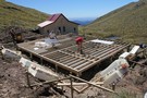
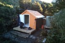
Kime Hut replacement
Photograph
•
Distance: 8.7km away
Builders working on the new Kime Hut (number 3) on 8/2/2013. 20 bunks, lots of insulation and double glazing. better ...
More ▶︎
New Kime Hut
Photograph
•
Distance: 8.7km away
Progress on the new Kime Hut near Mt Hector in the Tararua Range. taken on 1/3/2013. The cladding was completed ...
More ▶︎
The Tararua Range
Photograph
•
Distance: 8.8km away
Looking along the Main Range, into the heart of the Tararua from Hut Mound
More ▶︎
Kime White Out Winter, Tararuas
Photograph
•
Distance: 8.8km away
The track between Field and Kime Huts in the Tararua Forest Park. A mostly forgettable trip I did with a ...
More ▶︎
Elder Hut
Hut
•
Standard Hut (DOC). Capacity: 4.
•
Distance: 8.8km away
A tidy, new 4-bunk hut on the exposed summit of Elder Peak. Features windows round 2 sides looking over the ...
More ▶︎

Neill Forks Hut
Hut
•
Standard Hut (DOC). Capacity: 6.
•
Distance: 8.9km away
Hidden away and camouflaged in green and orange. 6 bunks with mattresses. Water from river. The fireplace is OK. Photo ...
More ▶︎
A Mid Waiohine Circuit: 'easier day tommorrow ...'
Article
•
Distance: 8.9km away
Memories on a winter circuit to visit Mid Waiohine from the Mangaterere roadend.
More ▶︎
Approach to Neil Forks hut
Photograph
•
Distance: 9.1km away
Nearing Neil Forks Hut from Maungahuka (1 min away!). Perfect spot to cool down after a sweltering & knee jarring ...
More ▶︎
Smith Creek up close and personal.
Photograph
•
Distance: 9.1km away
A shot from my misguided adventure into Smith Creek. Still - it was worth it for this shot and hey, ...
More ▶︎
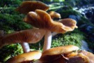
Smith Creek track mushrooms.
Photograph
•
Distance: 9.1km away
Shot these amazing looking guys on my recent trip through the Tauherenikau Valley and over Mt.Reeves.
More ▶︎
Sayers Hut
Hut
•
Standard Hut (DOC). Capacity: 6.
•
Distance: 9.2km away
A well maintained historic, but functional hut on the Waiohine River flats in the Tararuas. A beautiful hut, harkening back ...
More ▶︎
Bridge Peak looking towards Otaki Forks & Table Top
Photograph
•
Distance: 9.2km away
Track heading out to Otaki Forks from Kime Hut looking down towards Table Top. Early morning with some rain shadow ...
More ▶︎
Bridge Peak looking towards Otaki Forks & Table Top
Photograph
•
Distance: 9.2km away
Track heading out to Otaki Forks from Kime Hut looking down towards Table Top. Early morning with some rain shadow ...
More ▶︎
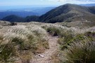
Table Top
Photograph
•
Distance: 9.2km away
View looking north comming down from Kime Hut.Otaki/sea to the left.
More ▶︎
View west from the Tararua Ranges.
Photograph
•
Distance: 9.2km away
View from bridge peak looking west overlooking the Otaki forks, the Otaki river & Otaki at the top.
More ▶︎
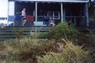
Totara Flats Hut
Hut
•
Serviced Hut (DOC). Capacity: 26.
•
Distance: 9.7km away
A central hut for the Kaitoke to Holdsworth trip (3 days). It was sited under trees at the north-west corner ...
More ▶︎
Totara Flats Hut
Photograph
•
Distance: 9.7km away
The new hut at Totata Flats, in the Tararuas
More ▶︎
Totara Creek
Photograph
•
Distance: 9.7km away
View from hut looking north.The Creek joins the Waiohine River.
More ▶︎
Totara Flats
Photograph
•
Distance: 9.7km away
On the track to Powell Hut in the Tararuas. Totara Flats in the distance
More ▶︎
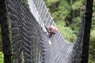
Waiohine Swing Bridge near Totara Flats
Photograph
•
Distance: 9.7km away
This was the swing bridge over the Waiohine River next to Totara Flats. On a some days the wind comes ...
More ▶︎
Totara Flats Hut - Sat 12 Dec Heavy Rain
Video
•
Distance: 9.7km away
Shot on a recent overnight trip into Totara Flats. Our first attempt to leave via Totara Creek was aborted as ...
More ▶︎