Nearby
Karaka Point
Snout Track
GPX file
•
Distance: 1.3km away
A short walk near Picton with good views of Tōtaranui / Queen Charlotte Sound.
More ▶︎
Queen Charlotte Track
GPX file
•
Distance: 4.7km away
Queen Charlotte Track over 4 days.
Slight detour to Punga cove accommodation
More ▶︎
Kaipupu Wildlife Sanctuary
GPX file
•
Distance: 5.1km away
Short loop track exploring the predator-fenced reserve.
More ▶︎
Black Rock campsite
Campsite
•
Basic Campsite (DOC). 6 spaces.
•
Distance: 5.7km away
A ridgeline campsite on the Queen Charlotte Track, just east of Torea Saddle. The campsite offers views of the sounds, ...
More ▶︎
East Cape to West Cape - the length of NZ's main divide
Track
•
125 – 300 days. Hard. One way.
•
Distance: 5.9km away
A guide to my route from East Cape to West Cape, the length of NZ's main divide.
More ▶︎
Picton to Aspiring
GPX file
•
Distance: 6.0km away
An aborted alpine traverse. Picton to West Cape, but aborted at Aspiring due to real world emergencies back home. Posted ...
More ▶︎
Queen Charlotte Track
Track
•
3 – 5 days. Easy. One way.
•
Distance: 6.2km away
A long but easy walk along Queen Charlotte Sound. This track offers hostel and resort accommodation as well as basic ...
More ▶︎
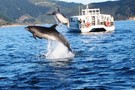
Water taxi on route to Ship Cove
Photograph
•
Distance: 6.2km away
Water taxi on way from Picton to the start of track at Ship Cove, came across some wildlife
More ▶︎
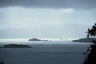
Kenepuru Sound.
Photograph
•
Distance: 6.2km away
Heading south along the track in the afternoon.Photo of Kenepuru Sound.
More ▶︎
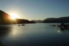
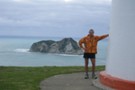
Portage at sunset
Photograph
•
Distance: 6.2km away
Portage (Marlborough Sounds) on the Kenepuru peninsula.
More ▶︎
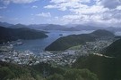
Tirohanga Walkway
Track
•
Easy. Return via same track or along streets.
•
Distance: 6.2km away
Short walk with panoramic views over Picton Harbour
More ▶︎
Route Guide: Richmond Ranges (east)
Article
•
Distance: 6.3km away
Tramping in the eastern Richmond Ranges between Picton and Okaramio (SH6)
More ▶︎
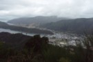
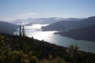
Picton Harbour and Queen Charlotte Sound from the Tirohanga Walkway
Photograph
•
Distance: 6.6km away
A good view of inner Queen Charlotte Sound.
More ▶︎
Queen Charlotte Track connector
GPX file
•
Distance: 8.3km away
Links the Queen Charlotte and James Vogel Tracks, leading down to Mistletoe Bay.
More ▶︎
Mistletoe Bay Eco Village
Campsite
•
Standard Campsite (Private). 42 spaces.
•
Distance: 8.4km away
This private campsite offers ample coastal camping space along with backpacker-style accommodation. Campers have access to a new camp kitchen ...
More ▶︎
Queen Charlotte Track connector
GPX file
•
Distance: 8.5km away
Links Onahau Road with the Peninsula Walk near Mistletoe Bay.
More ▶︎