Nearby
Mount Richmond Forest Park
Red Hills Ridge Traverse
GPX file
•
Distance: 3.2km away
Traverse of the Red Hills Ridge beginning from the Red Hills car park, returning via Mt Ellis, Hunters Hut, Porters ...
More ▶︎
Nydia Walkway
Track
•
2 days. Easy/medium. One way.
•
Distance: 3.5km away
A shorter neighbour of the Queen Charlotte Track, The Nydia Track explores low saddles and shorelines in the Marlborough Sounds.
More ▶︎
Nydia Lodge
Hut
•
Private hut (DOC). Capacity: 50.Bookings required.
•
Distance: 4.6km away
This DOC-owned Lodge, on the coast of the Nydia Bay is huge !
A specific house for the kitchen, one for ...
More ▶︎
Picton to Aspiring
GPX file
•
Distance: 5.6km away
An aborted alpine traverse. Picton to West Cape, but aborted at Aspiring due to real world emergencies back home. Posted ...
More ▶︎
Black Valley Walk
Track
•
Easy. One way.
•
Distance: 6.9km away
Link track between St Arnaud village and the campground.
More ▶︎

Te Araroa Trail
Track
•
95 days. Medium. One way.
•
Distance: 6.9km away
Te Araroa is a walking trail running the entire length of the North and South Islands. The trail opened 3 ...
More ▶︎
Saint Arnaud
Place
•
Place.
•
Distance: 6.9km away
An alpine village on the shore of Lake Rotoiti in Nelson Lakes National Park.
More ▶︎

Lake Thompson
Photograph
•
Distance: 6.9km away
A view of the beautiful Lake Thompson, a short distance from Thompson Pass
More ▶︎
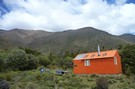
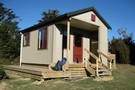
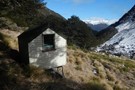
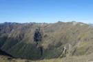
New Porters Creek Hut
Photograph
•
Distance: 6.9km away
moved to spot from right branch wairoa.
has beenlovingly restored with a new lick of 'rescue orange' paint and sports a ...
More ▶︎
Travers-Sabine
Track
•
4 – 7 days. Medium. Loop track with a road section.
•
Distance: 6.9km away
Two river valleys linked by a straightforward alpine saddle at 1800m
More ▶︎
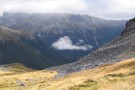
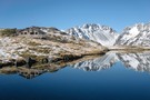
Travers-Sabine Saddle
Photograph
•
Distance: 6.9km away
Going over the saddle looking west towards the Sabine Valley - April 2010.
More ▶︎
Route Guide: Richmond Ranges (west) main ridge
Article
•
Distance: 6.9km away
The main ridge of the western Richmond Ranges from Mt Riley, near Okamario on SH6 to the Red Hills above ...
More ▶︎

Route Guide: St Arnaud to Lewis Pass
Article
•
Distance: 6.9km away
A 5-7 day north-south route from St Arnaud to the Lewis Pass, via Travers Pass, Waiau Pass, Thompson Pass and ...
More ▶︎
Gibbs Walk
Track
•
Easy. One way.
•
Distance: 7.0km away
Short link track betweem St Arnaud village and campground.
More ▶︎
St Arnaud Range Track
Track
•
1 day. Medium. Return by the same track.
•
Distance: 7.1km away
This walk climbs steadily through beech forest to a height of over 1650 metres.
Above the bushline (at 1400 m), ...
More ▶︎
Red Hills Hut
Hut
•
Basic Hut/Bivvy (DOC). Capacity: 6.
•
Distance: 7.3km away
The Red Hills Hut sits on the saddle between the Motueka (right branch) and the Wairau, and at the base ...
More ▶︎
Kerr Bay campsite
Campsite
•
Basic Campsite (DOC). 21 spaces.
•
Distance: 7.3km away
Grassy lakeside camping surrounded by a wealth of walking options, from short walks to alpine tops trips and multi-day tramps. ...
More ▶︎
Walking the length of the Richmond Ranges
Track
•
7 – 14 days. Medium/hard. One way.
•
Distance: 7.3km away
A 7-14 day walk along the spine of the Richmond Ranges. Alpine tops, crumbling ridgelines, untracked bush & scrub, boulders ...
More ▶︎
St Arnaud to Lewis Pass
Track
•
5 – 9 days. Medium/hard. One way.
•
Distance: 7.4km away
A 5-9 day north-south route from St Arnaud to the Lewis Pass, via Travers Pass, Waiau Pass, Thompson Pass and ...
More ▶︎
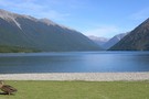
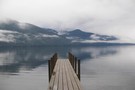
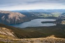
Lake Rotoiti
Photograph
•
Distance: 7.4km away
from the shore of St Arnaud, looking to the head of the lake and up the Travers Valley - Apr ...
More ▶︎
Bull Paddock Creek Track
Track
•
1 – 3 days. Medium. Return by the same track.
•
Distance: 7.4km away
Access To Bull Paddock Creek Biv from The Wairau river, this track follows Sand Fly Stream before dropping Bull Paddock ...
More ▶︎
Bull Paddock Creek Track
GPX file
•
Distance: 7.4km away
GPS file of track from Bull Paddock Creek Biv to the Wairau River
More ▶︎
Loop Track, Lake Rotoiti
Track
•
Easy. Loop track.
•
Distance: 7.5km away
A short walk through the Rotoiti Nature Recovery Project at St Arnaud. Lakeside beech forest.
More ▶︎
Honeydew Walk, Lake Rotoiti
Track
•
Easy. Loop track.
•
Distance: 7.5km away
This short loop leads into the edges of the Rotoiti Nature Recovery Project area, a "mainland island" with pest numbers ...
More ▶︎
Nelson Lakes - Lakehead, Angelus and Speargrass Circuit
GPX file
•
Distance: 7.6km away
From St Arnaud along Lake Rotoiti to Lakehead Hut, then crossing the Travers River and via the Cascade Track to ...
More ▶︎
Parachute Rocks Track
Photograph
•
Distance: 8.2km away
View of Lake Rotoiti from point 1738
More ▶︎
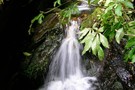
Refreshing waterfall
Photograph
•
Distance: 8.8km away
A small but much appreciated waterfall on the Nydia Track.
More ▶︎
Matai Bay Hut
Hut
•
Standard Hut (DOC). Capacity: 6.Bookings required.
•
Distance: 8.9km away
Hut located at the water's edge in Godsiff/Matai Bay, Tennyson Inlet.
More ▶︎
Anglers Walk, Lake Rotoiti
Track
•
Easy. One way.
•
Distance: 9.0km away
This track follows the first 2km of the Buller River from its source at Lake Rotoiti. It is well used ...
More ▶︎
Nelson Lakes National Park
Place
•
National Park. 1017.53km2.
•
Distance: 9.2km away
An alpine park of beech forests, valleys, and glacial lakes, offering some relatively easy walking. Established in 1956. Highest point: ...
More ▶︎
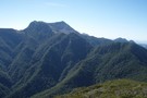
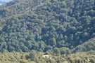
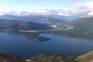
View over Silverstream and down Raglan Range
Photograph
•
Distance: 9.3km away
I took this photo looking generally southward when high on the Raglan Range. I was heading to Silverstream Bivvy and ...
More ▶︎
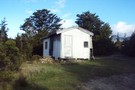
Maitland Hut
Photograph
•
Distance: 9.7km away
Not sure what happened to this hut. But it was in a great possy amongst the ultra mafic rocks with ...
More ▶︎
Maitland Hut
Hut
•
Basic Hut/Bivvy (DOC). Capacity: 4.
•
Distance: 9.7km away
A basic four bunk hut situated on the banks of the Right Branch Motueka River in the Mt Richmond Forest ...
More ▶︎
Bull Paddock Creek Hut
Hut
•
Basic Hut/Bivvy (DOC). Capacity: 2.
•
Distance: 9.9km away
Hut on the Raglan Range, east of the Wairau River. The hut is located near the bush line in Bull ...
More ▶︎