Nearby
Whitestone River
Boyd Creek to The Divide via Kiwi Burn and the Mavora Walkway
Article
•
Distance: less than 100m away
A New Year's trip through the Snowdon Forest and on to The Divide. Heavily affected by weather, I had to ...
More ▶︎
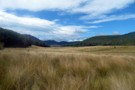
North Whitestone Flats
Photograph
•
Distance: 3.3km away
Large flats which lead from near the low saddle 597 all the way to the Whitestone River. These are private ...
More ▶︎
Kiwi Burn from the North
Photograph
•
Distance: 4.6km away
Approaching Kiwi Burn hut from the direction of the Whitestone River, its visible on the tree line. The track snakes ...
More ▶︎
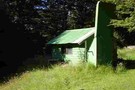
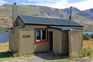
Kiwi Burn Hut
Hut
•
Standard Hut (DOC). Capacity: 12.
•
Distance: 5.2km away
Kiwi Burn Hut (12 bunks, wood-burning stove, water, firewood available) is a purpose built tramping hut located on the grassy ...
More ▶︎
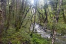
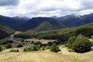
Snowdon Forest between the Whitestone and Upukerora
Photograph
•
Distance: 6.0km away
Typical scene while traversing between the Upukerora and Whitestone rivers. A lightly marked route follows the true right stream bank ...
More ▶︎
Army Hut
Hut
•
Basic Hut/Bivvy (DOC). Capacity: 5.
•
Distance: 6.5km away
Although basic by DOC's categories, this is a comfortable, well appointed 4-bed hut, maintained by local volunteers from Te Anau. ...
More ▶︎
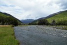
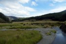
Upukerora River
Photograph
•
Distance: 6.7km away
Decent sized river that flows out of the Snowdon Forest and eventually through Te Anau to the lake. This is ...
More ▶︎
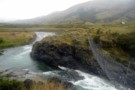
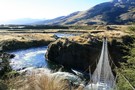
Kiwi Burn Swingbridge
Photograph
•
Distance: 6.7km away
The normal start of the popular Kiwi Burn tramping track. The bridge crosses the Mararoa River and then its a ...
More ▶︎
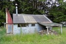
Army hut
Photograph
•
Distance: 6.8km away
Located on the Upukerora river, Army hut is an old deer hunters hut still in use today. Can be reached ...
More ▶︎
Boyd Creek to Upukerora Link Track
Track
•
1 day. Hard. One way.
•
Distance: 6.8km away
An old track linking Boyd Creek to the Upukerora via Dunton Swamp that is no longer maintained by DOC. There ...
More ▶︎
Upper Upukerora River
Photograph
•
Distance: 7.0km away
Panorama of the large flats above Army hut looking up river.
December 2013
More ▶︎
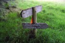
Boyd Creek "5 hours"
Photograph
•
Distance: 7.7km away
5 hours? Maybe in the 70's. Took me a bit about 9 hours and I wasn't fiddle-faffing around. This sign ...
More ▶︎
Mavora Lakes Walkways
Track
•
Easy/medium. Return by the same track.
•
Distance: 9.3km away
A magic place. Think glorious glassy (cold)lake. Reflecting snow covred mountains. Blue sky. Yes I know, all cliches.
More ▶︎
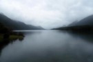
South Mavora Lake
Photograph
•
Distance: 9.9km away
A particularly wet New Year's Day at South Mavora Lake, looking up the lake from the swing bridge over the ...
More ▶︎