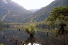
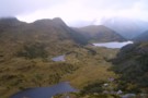
Nearby
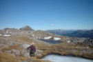
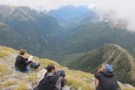
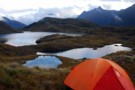
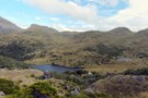
Tripod Hill from below Centre Pass
Above Centre Pass, Dusky Track
Photograph
•
Distance: less than 100m away
Just a short climb above Centre Pass (1050m) toward Mt Memphis (1405m) you reach the ridge bristling with tarns. The ...
More ▶︎
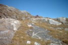
Leucosomes Above Centre Pass, Dusky Track
Photograph
•
Distance: less than 100m away
In gneiss or migmatite (high grade metamorphic rocks), you see segregations of light and dark bands. These bands can often ...
More ▶︎

Dusky Track
GPX file
•
Distance: 348m away
Basic route of the Dusky Track. You can add plenty of extras to this trip. Supper Cove, Mt Memphis, Tamatea ...
More ▶︎
Dusky Track
Track
•
8 – 10 days. Medium. One way.
•
Distance: 1.0km away
This journey explores the glacial valleys and mountains of Fiordland from Lake Hauroko to Lake Manapouri, visiting Dusky Sound along ...
More ▶︎
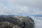
Spey Valley from Mt Memphis
Photograph
•
Distance: 1.8km away
Spey River valley, with fellow trampers, Ofer (from Israel) and Michael (from Belgium), both really strong walkers, who always got ...
More ▶︎
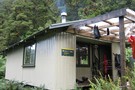
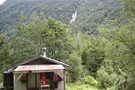
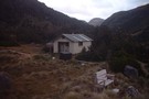
Kintail Hut
Hut
•
Standard Hut (DOC). Capacity: 12.
•
Distance: 2.1km away
Hut on the Dusky Track just southwest of Centre Pass.
More ▶︎
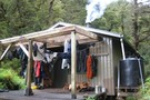
Upper Spey Hut
Hut
•
Standard Hut (DOC). Capacity: 12.
•
Distance: 2.7km away
On the Dusky Track.
More ▶︎
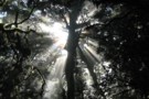
Spey valley sunlight
Photograph
•
Distance: 3.5km away
Sunlight through the trees in the Spey valley on the Dusky track. taken February 2007.
More ▶︎
Loch Maree Treestumps
Photograph
•
Distance: 6.5km away
The loch is full of drowned treestumps, which should they start dissapearing (due to the loch flooding), is a good ...
More ▶︎
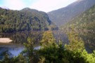
Loch Maree Hut
Hut
•
Standard Hut (DOC). Capacity: 12.
•
Distance: 6.6km away
On the Dusky track.
More ▶︎
More Loch Maree treestumps
Photograph
•
Distance: 6.6km away
2 days of no rain can certainly cause the loch water level to drop, revealing a sea of treestumps.
More ▶︎
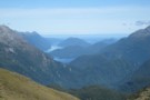
Dusky Sound
Photograph
•
Distance: 7.2km away
Dusky Sound from pt 1171 on the Pleasant range on the Dusky track. taken February 2007
More ▶︎
Loch Maree
Photograph
•
Distance: 7.2km away
Taken from above the bushline just before the epic descent down to the valley floor begins (700 verticle metres almost ...
More ▶︎
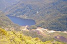
Seaforth River Valley
Photograph
•
Distance: 7.2km away
Looking North up the valley from above the bushline above Loch Maree, Tripod Hill is the large bushcovered hill slightly ...
More ▶︎
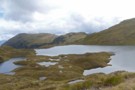
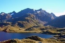
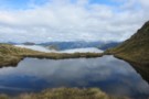
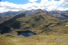
Lake Horizon panorama
Photograph
•
Distance: 7.7km away
Lake Horizon is nestled at about 1000m high, amongst the Pleasant Range, Fiordland. Our route is between the two lakes, ...
More ▶︎

The Highway to Spey Hut
Photograph
•
Distance: 7.7km away
High Speed Motoring!......"we all realized we were leaving confusion and nonsense behind and performing our One and noble function of ...
More ▶︎
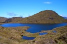
Lake Horizon
Photograph
•
Distance: 7.7km away
A large lake the Dusky track passes between Lake Roe and Loch Maree. A smaller lake, Lake Ursula is just ...
More ▶︎

Lake Roe and Furkert Pass
Photograph
•
Distance: 8.2km away
Taken from the Western side of the pass looking East. Lake Roe hut is visible centre of screen with Lake ...
More ▶︎
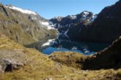
Merrie Range from near Tamatea Peak
Photograph
•
Distance: 8.4km away
We didn't actually get to the top of Tamatea Peak, as we needed the time to get down to Loch ...
More ▶︎
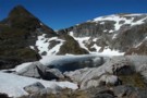
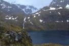
Tarn below Tamatea Peak
Photograph
•
Distance: 8.4km away
After hanging around in Lake Roe Hut hoping the fog might clear, we tentatively started up Tamatea Peak. This is ...
More ▶︎
4th lake (unnamed) in the Florence Stream
Photograph
•
Distance: 8.5km away
A fantastic series of lakes up the Florence Stream
More ▶︎
Lake Roe Hut and Furkert Pass
Photograph
•
Distance: 8.6km away
Taken from where you descend from Lake Roe to the hut.
The view is of unnamed Peak 1279 on the left, ...
More ▶︎

Lake Roe from below Pt1595
Photograph
•
Distance: 8.8km away
Descending the ridge towards Lake Roe
More ▶︎
The highest lake on the Florence Stream
Photograph
•
Distance: 9.0km away
Pt 1595 at right is the route over to the Merrie Range and Lake Roe. Pt 1566 on the left
More ▶︎
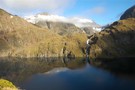
Jane Lake
Photograph
•
Distance: 9.1km away
In the Heath Mountains, Jane Lake is the source of the Jane Burn which drains to the head of Loch ...
More ▶︎
Lake Roe hut and Furkert Pass
Photograph
•
Distance: 9.1km away
Taken from ontop point 1037, looking Northwest across the pass. Lake Laffy is to the bottom left of frame with ...
More ▶︎
3rd lake up the Florence Stream
Photograph
•
Distance: 9.5km away
The route to the 4th lake is up the true left of the cascade , crossing about halfway up.
More ▶︎
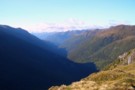
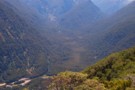
Hauroko Burn Valley
Photograph
•
Distance: 9.6km away
Taken from point 1072 looking South down the Hauroko burn. The Dusky track comes up this valley from Lake Hauroko ...
More ▶︎
Lake Roe and Tamatea Peak
Photograph
•
Distance: 9.7km away
Taken from point 1072 looking Northeast acrossing the southern end of Lake Roe. A beutiful spot on a sunny day, ...
More ▶︎
Third unnamed lake, Florence Stream, Fiordland
Photograph
•
Distance: 9.7km away
Third lake of the four that form the 'staircase' at the head of the north branch of the Florence Stream, ...
More ▶︎