Nearby
Cass Memorial Hut
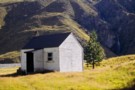
In and Out of the Jollie River
Article
•
Distance: 5.3km away
An easy 3 day sojourn up the Jollie to bag 2 huts.
More ▶︎
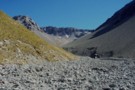
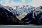
Cass River and Rutherford Pass
Photograph
•
Distance: 5.3km away
The west branch of the Cass River with Rutherford Pass in the distance
More ▶︎
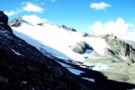
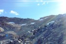
Ridge Glacier, Rutherford Pass
Photograph
•
Distance: 5.7km away
Ridge Glacier from the Rutherford Pass. This is a tough, unmarked alpine route from the Cass to the Murchinson Valley. ...
More ▶︎
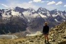
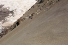
Ailsa Pass
Photograph
•
Distance: 5.9km away
Technically easy, but we required crampons on the Cass side (end Feb).
More ▶︎

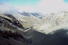
Murchinson Valley / Rutherford Pass
Photograph
•
Distance: 6.4km away
The Murchinson Valley from Rutherford Pass. This is a a tough 2272m pass between the Murchinson and Cass. Access is ...
More ▶︎
Route Guide: Otira to Mt Cook Village (pt 2)
Track
•
12 – 21 days. Hard. One way.
•
Distance: 6.4km away
One possible route down the main divide from Otira on the Arthur's Pass road to Mt Cook Village.
Otira Hotel ...
More ▶︎
Rutherford Pass
Photograph
•
Distance: 6.4km away
Rutherford Pass (Cass side), a 2272m pass between the Murchinson and Cass. The ascent zig-zags up scree between bluffs to ...
More ▶︎

Route Guide: Otira to Mt Cook Village (pt 1)
Track
•
12 – 21 days. Hard. One way.
•
Distance: 6.4km away
One possible route down the main divide from Otira on the Arthur's Pass road to Mt Cook Village.
Otira Hotel to ...
More ▶︎

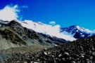
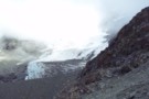
Murchinson Glacier
Photograph
•
Distance: 7.7km away
Views of the black Murchinson Glacier from below Rutherford Pass
More ▶︎
Picton to Aspiring
GPX file
•
Distance: 7.9km away
An aborted alpine traverse. Picton to West Cape, but aborted at Aspiring due to real world emergencies back home. Posted ...
More ▶︎
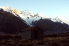
Liebig Hut
Photograph
•
Distance: 8.1km away
Liebig Hut, in the Murchinson Valley. Access to the valley is by boat over the Tasman Glacier Lake - tourist ...
More ▶︎
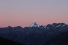
Mt Sefton from Liebig Hut
Photograph
•
Distance: 8.1km away
Sunrise catches Mt Sefton. From the Liebig Hut, in the Murchinson.
More ▶︎
Liebig Hut
Hut
•
Standard Hut (DOC). Capacity: 6.
•
Distance: 8.1km away
Liebig Hut (6 bunk, matresses, no fire, water at 200m, mountain radio) is a DOC hut on the south side ...
More ▶︎
Huxley Glacier
Photograph
•
Distance: 8.2km away
The Huxley Glacier, descending from Mt Hutton into the upper Cass Valley. The private Rankin and Memorial Huts nearby provide ...
More ▶︎
Rankin Pass
Photograph
•
Distance: 8.4km away
Technically easy, few hours from Rankin Hut in Godley. Few more hours down to Cass Memorial Hut.
More ▶︎
Rankin Stream / Rankin Pass
Photograph
•
Distance: 8.5km away
Rankin Stream from the Godley River flats. The notch on the left of the valley is the Rankin Pass, a ...
More ▶︎
Cass River, East Branch
Photograph
•
Distance: 8.5km away
The head of the Cass river from Rankin Saddle. The Huxlrey glacier descends into the western half of the valley ...
More ▶︎
Huxley Glacier
Photograph
•
Distance: 8.5km away
The Huxley Glacier, in the upper Cass River - seen from Rankin Pass.
More ▶︎
Onslow Hut (Steffan Memorial Hut)
Hut
•
Basic Hut/Bivvy (NZDA). Capacity: 4.
•
Distance: 9.7km away
NZDA hut located on the Murchison River just below the glacier lake.
More ▶︎