Haurangi North-South Tarck
- 2 – 4 days one way
- Medium
- The tracks shown on the map are, to a large degree, mythical – most of the valley floor travel is along the riverbeds, with good marked tracks running over the saddles.
- The catchments may be small, but the valleys are tight, and this would not be a good place to be in heavy rain – especially the section from Pararaki Hut south.
- To exit at The Pinnacles on the coast road in the west,
- Exit at Waikuku Lodge in the east on the
- A tough third option is to cross the untracked ridge from Sutherlands Hut to Tauanui Hut and exit up the
A 2-6 day tramp running the length of the Haurangis from Cape Palliser (or Ngapotiki) in the south to The Pinnacles (or Haurangi Road roadend, or Pirinoa) in the north.
Black sand beaches, dunes, seals with dental hygiene issues. Mature manuka river flats, twisting riverbed routes through tight gorges, tracked climbs through lush podocarp bush. Untouched native bush, post-logging regeneration.
|
Walking time
|
2 – 4 days |
|---|---|
|
Distance
|
35.0km |
|
Type
|
One way
|
|
Grade
|
Medium
Some riverbed travel in south. Not advised after heavy rain. Grades explained
|
|
Bookings
|
No bookings — open access
No — open access
|
|
Starts
|
Cape Palliser / Ngapotiki |
|---|---|
|
Ends
|
The Pinnacles (Te Kopi) / Haurangi Road roadend |
|
Maps
|
NZTopo50-BR33
NZTopo50-BQ33 |
|
Altitude
|
Sea level
–
981m
Altitude change 981m
|
The Haurangis, as a little visited part of the country, have always appealed. The map shows a track running south-north for most of their length from
The most important point to make here is: this assumption is wrong: The Haurangi north-south track is not a ‘good wet weather option’.
That said, in dry weather, the Haurangis make for enjoyable tramping, and a pleasant change from the Tararuas and Ruahines. The valley trip provided good shelter from the wind, which forced me down here as an alternative to the Tararua tops.
The trip described here is a south-north walk starting from
In the north, three options exist:
Whichever option is taken, this trip needs two vehicles. I left a bike at the Pinnacles end of the Sutherland road and cycled back to
3.5km, 1-2hrs, riverbed route
The walk starts at the Mangatoetoe bridge 2km west of
The valley slowly tightens and becomes scrubbier. By the time you reach the hut you are in tall manuka scrub / bush. The hut itself is in a small clearing 30m from the river on the east side, reached by an unmarked track. The hut is not visible from the river and easy to miss – check the map as you go to see where to start looking out for the track.
Mangatoetoe Hut is the newest of the huts built in the
Mangatoetoe Hut to Kawakawa Hut
7km, 2-4 hours, riverbed route with cut track over saddle
Above Mangatoetoe Hut it’s back to river travel – through increasingly mature podocarp bush – the kanuka left behind with the flats. A randomly located sequence of triangles have been nailed to trees on both banks, but they do not give any useful information about which side of the river to travel on, and merely confuse the tramper looking out for the start of the track. In the end, it’s a case of follow the riverbed, because any travel on the banks will be short and frustrating. When you get there, the climb out of the river is obvious. A well marked, cut track heads up the obvious spur at the river fork - as shown on the map - climbing quickly to the saddle. Beyond the saddle there’s some serious sidling of steep, crumbling valleyside, before dropping to the Otakaha Stream for more wet feet and river travel. Walking down the riverbed, the valley is tight and winding, the sides near vertical, reminiscent of the mud-stone gorges of the Uraweras. For much of the way, the only flat land is that occupied by water. The stream passes two tributaries on the right, which seem far too big to be those shown on the map, but are. About 400m before the hut the valley suddenly opens to grassy / scrubby flats. A gravel 4wd track appears on the true right and leads to the hut, just upriver of the major fork in the Otakaha.
Kawakawa Hut is a 6-bunker with a wood burning stove, plenty of firewood nearby, and water from the river. It sits back in mature Manuka bush on the valley floor, 50m from the river. The hut is 4wd accessible (with permission) via Kawakawa station, but despite this is in good condition: a pleasant hut.
Kawakawa hut to Pararaki Hut
4km, 1.5-3 hrs. Track
The track up the north branch of the Otakaha, starting at the forks below Kawakawa hut, is amazing: hut book comments call it ‘the ladies mile’. Given it’s more than a mile to Pararaki you may rightly suspect that it won’t be this good all the way.
The platformed, cut track runs up the true left to the next forks, where reality returns as it fords the river and becomes a narrow, marked, roughly cut track through thick undergrowth, climbing steeply up the spur between the two forks. However, it is still an improvement on the river routes further south. In a couple of places the track drops to large creeks, follows them to flats , and crosses them – the topology clearly more complicated than shown on the map which features just one creek to cross before the saddle. From the saddle it’s a steep but good descent to Pararaki stream and the forks just below the hut.
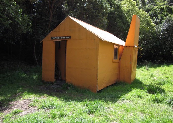
Pararaki Hut is about 50, up the NE fork, hidden from view behind a grassy bank.
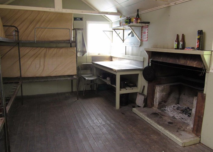
The bright orange hut (the colour god intended huts to be!) is a pleasant 6-bunker with a fireplace and water from the stream 20m away.
Pararaki Hut -> Washpool Hut
2-4hrs, 4km. Cut track
The track to Washpool climbs the ridge directly behind Pararaki Hut – 550m to the top and I felt every meter of it. A well marked, well cut track but a relentless gradient: the first 200m bloody steep, the rest merely steep. However, glimpse views from the climb, and a good clearing at the top the top look out along the coast past Lake Ferry and Ocean Beech and across to the Seaward Kaikouras - snow-capped with fire in the evening sun. There’s even cellphone coverage at the summit – the only point on the trip. You can decide if that’s a good or bad thing.
Cruise tape (flagging / marker tape to you northerners) wrapped round a tree near the summit marks the turn off along the ridge towards Sutherlands Hut. More about this below.
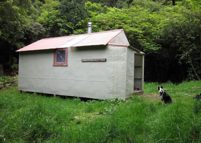
The descent to Washpool is equally steep – increasingly so as you lose altitude. I lost the track 50m above the creek, and dropped to the river at a fork 100m up from Washpool Hut. The track may exit closer, if you can follow it. Downriver from the fork a sign on the true right points to Washpool Hut. The hut is 60m above the creek up a good track.
Washpool Hut is the dankest, darkest hut in the range. Sleeps 6 on mattresses which each feature the outline where the previous occupants have worn the layer of mould off the surface with the friction of their bodies. In fact, everything is covered in mould. Get used to it or leave. There’s no tank at the hut, but a small side creek 100m along the terrace upriver avoids the need to drop to the main creek. I never found the washpool.
There’s also a fire: the previous occupants left me 10 pieces of sodden wood, the ash in a plastic bag on the floor, the floor unswept. Knowing I’d be bored they left me their dishes to do: so thoughtful – more mould, and they’d found such a convenient place to put them too: the water bucket. The chances of finding anything dry enough to burn in the surrounding bush were nil.
Do you get the impression I didn’t like the place?
Washpool – Pinnacles roadend
10km, 4-8hrs, track
This is covered in a separate article: |here
Washpool / Pararaki -> Sutherlands Hut
8km, 3-6hrs, track / marked route / 4wd track
This is an alternative exit point to The Pinnacles, taking in Sutherlands Hut and optionally Mt Ross.
Follow the track between Pararaki and Washpool to the summit and look out for a tree adorned in excessive marker tape. From here a well marked route follows the ridgeline NNE to the
500m before the
Assuming you didn’t climb Mt Ross, from the junction of the ridgeline route with the 4WD track; follow the 4WD track downhill with increasing gradient, to get to the hut after 3km.
Sutherlands Hut is more a house than a hut. Sleeping 7 with a separate kitchen, and a couple of other rooms which are now derelict. It’s a little run down (2010) but still very usable. Features tank water (broken when I visited – stream nearby) and an open fire (also broken, but easily fixed by rearranging some brickwork).
Sutherlands Hut -> roadends
5km or 15km – 1hr / 3-5hrs
Sutherlands Hut is 5km from the gate at the eastern end, and 15km from the east coast road at Te Kopi. Gates at each end are locked, but permission for vehicle access is possible – ATV or motorbike is the only vehicular option heading west. Or you can walk, or mountain bike it at will.
Sutherlands Hut -> Tauanui Hut
10km - 5.5-11 hrs, tough ridgeline route. Good navigational skill required. Map / compass a must.
From the forks 1km downriver of Sutherlands, climb the downriver ridgeline. 1st 100m are steep, loose and scrubby, but going gets better beyond. Follow ridgeline to Te Maunga Summit - scrubby in places but generally average going. The descent from several of the peaks on the way is challenging: ridgelines do not become obvious until some distance below the summits, and you drop off the peak on a bearing with little visibility due to trees. Good map/compass skills are a must.
Te Maunga features a large clearing and promises of good views in clear weather. Descend the ridge which leads directly to Tauanui Hut. A band of thick undergrowth for 200m above the valley floor makes the lower part of this slow but managable going.
Tauanui Hut -> Pirinoa / roadend
11km, 4wd track
A 4wd track runds down the valley from the hut, meandering through scrub, bush and crossing the stream. Pleasent going 3km to the forestry at the park boundary. 7km on standard forestry / farm track beyond to locked gate. Pirinoa 3km beyond down the road. Permission may be required from farmer (Didsdale: 06 3077867).