South Coast Track: Cape Palliser to Ngapotiki Hut
- 2 hr – 4 hr return via same track
- Easy
An easy day or overnight trip along the North Island's South Coast track from Cape Palliser to Ngapotiki Hut.
This is an easy walk for all levels of ability along a track which is open (at times) to 4WD vehicles, but don't let that put you off. The south coast track leads east from Cape Palliser along rugged rocky coastline, past rocky headlands and black sand beaches. Inland the windswept southern flanks of the Haurangi Ranges rise 300m-600m from the coastal plain. The track cuts across grassy flats, winds through wind-stunted scrub and boulder-fields and traverses beaches and outwash fans. One stream must be forded, the Waitetuna - this is crossed at the ford on the 4wd track and shouldn't come over you boots in most conditions.
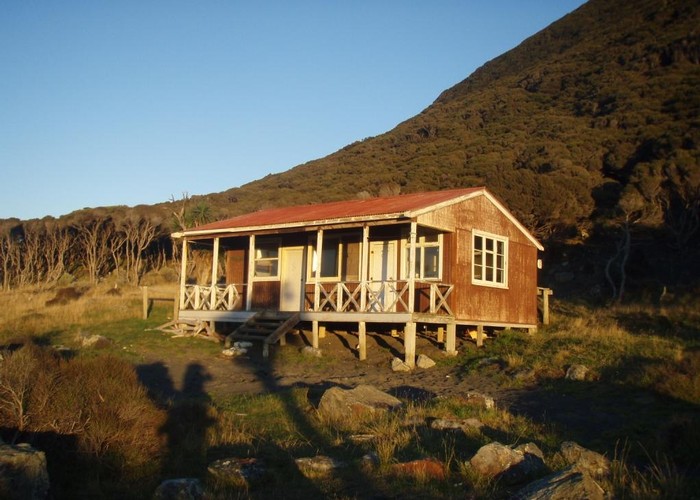
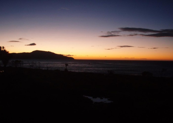
Spend a night at the the southern-most hut in the North Island: Ngapotiki Hut, listening to the surf pound on the beach 50m away. Wake to the sunrise over the Pacific.
|
Walking time
|
2 hr – 4 hr |
|---|---|
|
Distance
|
7.0km |
|
Type
|
Return via same track
|
|
Grade
|
Easy
One stream crossing. Maybe wet feet, but nothing worse. Grades explained
|
|
Bookings
|
No bookings — open access
No — open access
|
|
Starts
|
Cape Palliser |
|---|---|
|
Ends
|
Ngapotiki Hut |
|
Maps
|
NZTopo50-BR33
|
|
Altitude
|
Sea level
–
100m
Altitude change 100m
|
Access:
=======
Head down the Cape Palliser road, past the settlement at Cape Palliser and the lighthouse. The road crosses a ford just before the lighthouse, but this is concrete floored and passable in 2wd vehicles in most conditions. Park in the carpark at the roadend at Rocky Point.
Directions:
===========
From the carpark, directions are simple: follow the 4WD track through the locked gate, and east along the coast. The track starts off broad across the grazed coastal strip east of Cape Palliser. There are usually seals on the rocks around Rocky Point. The track soon narrows and becomes rocky as it winds its way though increasingly dense vegetation and boulder-fields.
The only significant stream on the route is crossed after 3.5km, at the outflow from Stonewall Basin. This wide-floored valley in the southern part of the Haurangi Range narrows to a cleft just meters across at its exit, forcing the Waitetuna through as series of pools and waterfalls to reach the coast. For those interested in exploring, the ridges to the east of the river provide the only access into the valley. The western and southern valleysides are steep crumbling bluffs and impassible.
From the Waitetuna, the track begins to climb and sidle the hillside as the coastal plane shrinks and disappears, before dropping back to a black-sand beach. Finally it climbs again through sand and gravel cliffs to cross the outwash fan of the unnamed stream 1km before the hut.
Ngapotiki Hut is on the left of the track and hard to miss, it's the only building on the walk (the building 2km beyond at the Ngapotiki roadend is a private house). Considering the hut is 4WD-accessible it's in surprisingly good condition. There's a couple of broken armchairs on the deck to give it a run-down look, and the door needs something along the bottom to stop the sand blowing in through the gap - but that aside it was comfortable, clean and tidy. The hut sleeps 15 in two rooms: 9 in the kitchen / main room and 6 more in a separate bunk room. However, there were only three mattresses in 2010 when I visited! The hut has a new woodburner, and there's plenty of driftwood and manuka scrub to burn. There's tank water and sinks in both rooms.
The trip makes a good easy overnighter, or the hut can be a base to explore Stonewall Basin or head north. It is little visited by trampers: but doze off with the sound of the breakers on the beach, and wake to a golden sunrise over the sea, and you'll wonder why.
Return the way you came, or continue 2km to the Ngapotki roadend.