Rocky Creek / Griffin Creek
- 2 – 3 days loop track with a road section
- Medium
2 day circuit in luxurious west coast bush with short above the bushline tussock section. 2 huts, Griffin Hut is magical, complete with bath down by the river. This route guide covers the reverse of the direction described by Matthew. It is usual to see blue ducks in both Rocky and Griffin Creeks.
|
Walking time
|
2 – 3 days
12 hr – 15 hr
|
|---|---|
|
Distance
|
14.0km |
|
Type
|
Loop track with a road section
|
|
Grade
|
Medium
Suitable at moderate to low flows only. Griffin Ck side currently overgrown so attention required. Best to be able to read maps on this trip at the moment. Grades explained
|
|
Bookings
|
No bookings — open access
No — open access
|
|
Starts
|
True left of Taipo River at bridge on Highway 73 |
|---|---|
|
Ends
|
True left of Harrington Creek where crosses Highway 73 |
|
Maps
|
NZTopo50-BV20
|
|
Altitude
|
115m
–
1,020m
Altitude change 905m
|
After crossing the Taipo road bridge look for a pathetic attempt of a gate formed by baling twine and rope strung across a 4WD track. Take this track to a clearing 50m distant which is sometimes used as an apiary. Park here or a further 20m down the track. The 4WD track heads 10m down a bouldered and shady cutting to a tiny pristine watercressed stream. Cross the stream and head via grassy clearings threatened with blackberry and gorse encroachments to the banks of the Taipo where cutty grass abounds. The route is marked with pink cruise tape to this point and takes about 10 minutes to walk.
From here you can travel via a short track in the gloomy forest to a small side creek. Cross this to come on to the start of the track leading to the edge of an extensive slip. However there was a massive flood of this tiny side creek in the spring of 2013 so just go down to the Taipo River bank and keep an eye out for the start of the track on the true left of this small creek which now flows in a big debris flow. Within the debris flow rocks are very large soapstone boulders and some very dark green serpentine rocks.
This track on the terrace has now been completely recut and initially follows the edge of the terrace, then drops downhill briefly but suddenly changes tack and sidles across to Rocky Creek, initially following the creek uphill for 4 minutes on the edge of a precipitous terrace on the true left of Rocky Creek then dropping down to a lower terrace and eventually to the bank of Rocky Creek, itself. Here the track ends as it was taken out by a large slip so enter the water for the first of two crossings. After crossing the river you'll need to climb up to the terrace on the true right briefly then come down to the river's edge again until you need to recross the river to the true left. From here be attentive for signs to pick up the track again downstream of a second larger waterfall on the true left.
This track starts here in a greasy narrow section where it crosses a little level prominence, drops down to the river briefly (50m) then heads up a tiny waterfall to verdant bush, crosses a couple of tiny streams and then climbs to an open scarred slumped section and enters the bush again for 200m. Finally it emerges in the open riverbed just upstream of a gorged section. You can travel via the rocky riverbed on the true left until the river closes up again. However if you are attentive, you can also travel via several bypass tracks. Some are better marked than others with white tin lids and other marker paraphenalia such as blue cruise tape. These tracks are quicker than the river bed travel. There are also some cool flood channel sections.
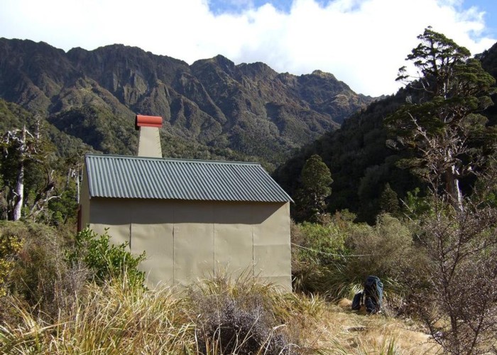
Then basically you can travel up the river itself to a track just upstream of Rocky Hut just beyond an extensive logjam of toppled trees. However the track to the hut leading from downstream of the hut is no longer overgrown and a nice change from the river travel. The hut is in a recently burnt small clearing surrounded by mountain cabbage trees. From the hut drop back down to the river and travel upstream, taking care to choose the right tributaries as per the map. A cairn is marking one decision point. This was rebuilt in January 2014, with permolat markers and cruise tape replaced at the junction. If you choose the wrong (true left, climber's right) tributary, you'll eventually come to an impassible waterfall according to the previous hutbook. Frank and I have created a campsite at this junction in the cutty grass big enough for 3 people under a fly or 2 people in a tent.
The creek narrows and has been cut open of overhanging hebe etc. most of the way up to the first waterfall where a short bypass track has been cut. It is quite clambery in places on black and white shist bedrock but suddenly opens to a silvery fine slip on the true left.
Just past this slip, you enter the forest again and will find indications of a steep short 50m track in forest, leading to the saddle via a boggy little trickle which has just been recut and permolatted by us in February 2014. The track on the saddle is closer to the south end of the saddle, not near the slip as shown on the map.
From the saddle the track used to be well defined in places and steep, descending via little streams to attractive forested spurs with good markings bypassing waterfalls. Matthew has described the route more thoroughly although I don't recall windfalls: just the reality of an unmarked track which requires quite a bit of stream travel. Last time we did this it was in complete darkness so it can't be too difficult to suss.Greg Ross cleared an entrance to the second bypass 500m upstream from the tributary's junction with Griffin Creek a couple of years ago and Frank and I did some recutting in March, 2014.
The main track from Mt Griffin crosses a side stream. Be careful not to then continue travelling up a side stream leading to Scotty's Saddle! You want to be travelling in a south-west to south direction, not south-east! There is actually a junction of 2 tracks well marked by Greg. The track to Griffin Hut travels via a terrace. The hut is in an open clearing on a lower terrace 20m above Griffin Creek. It is a magical place and includes a bath down by the river.
From the hut, retrace the track to the second side stream downstream and cross this stream to travel on the true right for some distance before crossing Griffin Creek several times. A track starts about 45 minutes downstream of the hut. It climbs to point 974 and is quite steep, initially through boggy cutty grass, alongside a slip to magnificent rata forest, a lookout and then the mossy grassed tops where the plastic slimy water barrel deteriorates even further. I have actually camped nearby and drunk the stuff.
The track is a bit overgrown and needs TLC. Lots of people have made effective efforts to mark it in various ways and done occasional track maintenance. It is quite steep but must be followed with attentiveness as it has a few doglegs. It eventually flattens out and sidles down to Harrington Creek. Cross the creek to the true left and pick up a track that takes you to the old moss covered section of highway 73 that can be used as a parking zone.
It would be a marvelous thing if anyone going in carried secateurs, loppers, and pruning or bowsaws and some form of track marking as following the track on the Griffin side to the Rocky/Griffin Saddle is getting to be a bit of a challenge for some folks.