Nearby
fiordland for fun
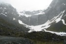
Gill's Biv
Rock bivouac
•
Distance: 659m away
A large rock dropped of the Darran Range, located at the head of Lake Adelaide. Mike Gill identified the biv ...
More ▶︎
Phil's Biv
Rock bivouac
•
Distance: 1.5km away
Rock biv high above the head of lake Adelaide, beneath Marian Peak. Several rocks provide rooms with benches.
Note: Approximate ...
More ▶︎
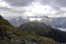
Gertude Saddle
Photograph
•
Distance: 2.5km away
In the Gertrude Valley, just the Te Anau side of the Homer Tunnel. One of the best day walks in ...
More ▶︎
Homer Hut
Hut
•
Serviced Hut (NZAC). Capacity: 30.
•
Distance: 5.0km away
Well-equipped NZAC hut located in the Gertrude Valley east of the Homer Tunnel. This hut is most popular with climbers ...
More ▶︎
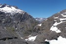
The tops of the Darran Mountains - Fjordland NZ
Photograph
•
Distance: 6.8km away
The exit from the Lake Nerine basin when heading to North Col overlooks the lower end of Hidden Falls Ck ...
More ▶︎
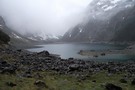
Lake Marian
Photograph
•
Distance: 8.0km away
Taken in October 2010 the lake appeared tiny in comparison to other photos and videos Ive seen of it online, ...
More ▶︎
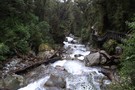
Lake Marian
Track
•
Easy/medium. Return via same track.
•
Distance: 8.0km away
Short walk from the Hollyford Road up to a hanging valley and lake in the Darran Mountains.
More ▶︎
Big Bay - Pyke - Hollyford Road-end Route
GPX file
•
Distance: 8.1km away
Big Bay - Pyke - Hollyford Road-end Route as tramped by us in May 2012 and recorded with Garmin GPS60csx
More ▶︎
Hollyford Track
Track
•
4 days. Medium. One way.
•
Distance: 8.3km away
The Hollyford Track is a classic lowland Fiordland route from the Hollyford Road out to the coast at Martins Bay.
More ▶︎
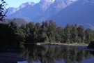
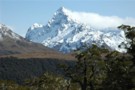
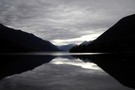
View from Lake Alabaster
Photograph
•
Distance: 9.1km away
mountain shot from Lake Alabaster
More ▶︎