Nearby
Wangapeka Tramp
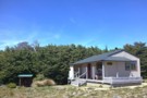
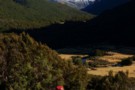
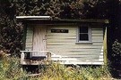
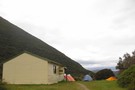
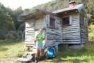
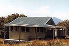
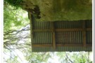
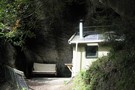
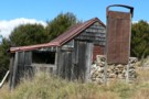
Sylvester Hut
Photograph
•
Distance: 1.2km away
Sylvester Hut as you return from Lake Sylvester. (better photographs invited ;)
More ▶︎
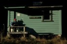
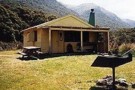
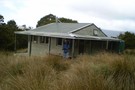
Sylvester Hut
Hut
•
Serviced Hut (DOC). Capacity: 12.
•
Distance: 1.2km away
Modern 12 bunk hut with heater (not stove), bench seating and two sleeping platforms with a sink and two toilets ...
More ▶︎
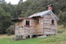
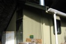
Lake Sylvester Hut
Photograph
•
Distance: 2.0km away
Replacement/ Upgrade of "Bushline Hutt"
More ▶︎

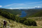
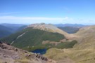
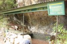
Cobb Reservior from Lookout
Photograph
•
Distance: 3.0km away
view on the way to Balloon Hut.
More ▶︎
The Way Down
Photograph
•
Distance: 3.2km away
If you're heading S along the Lockett Range, don't worry about where to descend to Lake Sylvester - it's pretty ...
More ▶︎
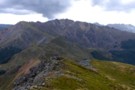
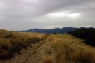
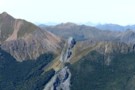
Lockett Range
Photograph
•
Distance: 3.5km away
looking N along the Lockett Range to Mt Benson -
from Iron Hill
Feb 2017
More ▶︎
Cobb River campsite
Campsite
•
Informal campsite (DOC). 20 spaces.
•
Distance: 4.3km away
Camping on grassy river flats in the Cobb Valley. Ample walking options in the area.
More ▶︎
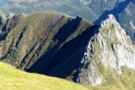
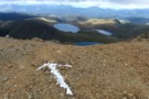
Gendarme on the Lockett
Photograph
•
Distance: 4.7km away
a gendarme on the Lockett Range, requiring a sidle (easy) under SH1503. More challenging is the descent from SH1672, first ...
More ▶︎
Lake Peel
Track
•
1 day. Easy/medium. Return by the same track.
•
Distance: 4.8km away
Pleasant walk to an alpine lake in the Cobb Valley.
More ▶︎
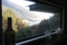
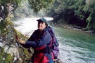
View from Myttons Hut, looking up Cobb Valley
Photograph
•
Distance: 5.0km away
Lynette Salisbury on the Cobb. Distant peaks at valley head are Xenicus Peak & Aorere Peak.
More ▶︎
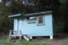
Myttons Hut
Hut
•
Basic Hut/Bivvy (DOC). Capacity: 4.
•
Distance: 5.0km away
Four bunks with mattresses. Water from tap outside - possibly from nearby creek.
From 1994, DOC have stopped maintaining this quaint ...
More ▶︎
Cobb Valley
Track
•
2 days. Easy. Return by the same track.
•
Distance: 5.0km away
A beautiful, easy tramp for beginners. The valley had many grassy flats so there are wonderful views all the way. ...
More ▶︎
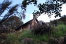
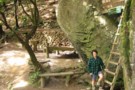
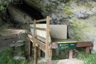
Asbestos Cottage
Photograph
•
Distance: 5.1km away
First view as you come out of the bush into the clearing
More ▶︎
Asbestos Cottage
Hut
•
Basic Hut/Bivvy (DOC). Capacity: 4.
•
Distance: 5.1km away
A quaint hut with history - some of the original occupant's belongings still present and in use.
Asbestos Cottage was ...
More ▶︎
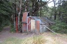
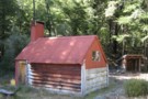
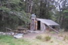
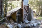
Trilobite Hut
Photograph
•
Distance: 5.1km away
cosy hut with log fire, easy access, good starting point to explore the area.
More ▶︎
Trilobite Hut
Hut
•
Standard Hut (DOC). Capacity: 12.
•
Distance: 5.1km away
A large road-end hut. Picnic table and barbecue outside.
More ▶︎
Asbestos Track
Track
•
0 – 1 day. Easy/medium. Return by the same track.
•
Distance: 5.3km away
A gently graded mine road climbing to an asbestos mine and 1890s cottage.
More ▶︎
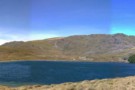
The route to Lake Peel
Photograph
•
Distance: 5.8km away
The Cobb Reservoir fills the glacial valley.
More ▶︎
Waingaro Forks Hut
Hut
•
Basic Hut/Bivvy (DOC). Capacity: 4.
•
Distance: 6.0km away
Historic hut located on the terrace where the Stanley and Waingaro Rivers meet on the Waingaro Pack Track. The hut ...
More ▶︎
Chaffey Hut - Cobb Valley
Photograph
•
Distance: 6.4km away
The recently renovated Chaffey Hut in the Cobb Valley is a rustic 3 bunk shelter.
More ▶︎
Chaffey Hut
Photograph
•
Distance: 6.4km away
Photo taken of restored hut 5/5/13. Three bunks with mattresses.
More ▶︎
Mt Lockett (Kahurangi NP)
Photograph
•
Distance: 6.5km away
View from Mt Benson on the Lockett Range, looking toward Mt Lockett. Ruby Lake in the foreground, Diamond lake at ...
More ▶︎

Chaffey Hut
Hut
•
Basic Hut/Bivvy (DOC). Capacity: 3.
•
Distance: 6.5km away
This hut was built by NZFS ranger Jack McBurney in 1953. By 1994 it was no longer maintained and becoming ...
More ▶︎
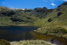
Lake Peel
Photograph
•
Distance: 6.7km away
Pretty, circular lake in Kahurangi National Park.
More ▶︎
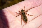
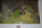
Dragonfly nymph
Photograph
•
Distance: 6.7km away
Floating in Lake Peel, in the Cobb Valley.
More ▶︎
Gendarme on the Lockett
Photograph
•
Distance: 8.0km away
gendarme on the Lockett Range - but taken from behind (from Kakapo Peak), showing SH1672 and the scree descent (or ...
More ▶︎
Balloon Hut
Hut
•
Serviced Hut (DOC). Capacity: 14.
•
Distance: 8.3km away
Gas cooker and heater. Great views of the Arthur Range and over the headwaters of the Leslie River (from Balloon ...
More ▶︎
Lower Gridiron Shelter
Photograph
•
Distance: 8.7km away
Lower Gridiron shelter. taken 18-Mar-2006
More ▶︎
Lower Gridiron Shelter
Hut
•
Basic Hut/Bivvy (DOC). Capacity: 4.
•
Distance: 8.7km away
4 person hut bivvy under rock overhang
More ▶︎
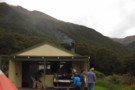
Balloon Hut
Photograph
•
Distance: 8.8km away
5 star accommodation, gas burner & cooker provided!! Approxmately 4 hr from Trilobite Hut
More ▶︎
Mt Arthur to Murchison
GPX file
•
Distance: 8.8km away
track from Mt Atrhur Tablelands to Murchison via Wangapeka Saddle, Nugget Knob and the Matiri Valley
More ▶︎
Dry Rock Shelter
Hut
•
Natural shelter (DOC). Capacity: 3.
•
Distance: 9.2km away
Dry Rock Shelter. An open air shelter under a rock overhang, but with a sleeping platform and mattresses.
More ▶︎
Upper Gridiron picture window
Photograph
•
Distance: 9.3km away
The picture window above the door at Upper Gridiron hut. taken Mar 2006
More ▶︎
Upper Gridiron Hut
Hut
•
Standard Hut (DOC). Capacity: 3.
•
Distance: 9.3km away
Half hut and half rock overhang -- a most unusual place.
More ▶︎
Tablelands Circuit
Track
•
2 days. Easy. Loop track.
•
Distance: 9.7km away
Joins onto Leslie-Karamea Track.
More ▶︎

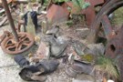
The Fridge that used to be at Upper Gridiron Shelter
Photograph
•
Distance: 9.7km away
Not there anymore.
More ▶︎
Riordans Hut
Hut
•
Basic Hut/Bivvy (DOC). Capacity: 3.
•
Distance: 9.8km away
An historic hut located on the Lockett Range above the Takaka River. The hut was constructed in 1926 as a ...
More ▶︎
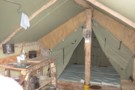
Tent Camp Hut, Cobb Valley
Hut
•
Basic Hut/Bivvy (DOC). Capacity: 3.
•
Distance: 9.8km away
This is the last remaining Forest Service deer culling camp, the meat safe still hangs in a nearby tree. There ...
More ▶︎
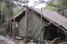
Tent Camp
Photograph
•
Distance: 9.9km away
newly refurbished - lots of good camping all about
Mar 2017
More ▶︎
Cloustons Mine Track
Track
•
Easy/medium. One way.
•
Distance: 9.9km away
Leading from the Salisbury Track on Flora Stream up past Cloustons Mine to Gordons Pyramid (1489m).
More ▶︎