Nearby
Upper Perth River
Adams Wilderness Area
Place
•
Wilderness Area. 465.87km2.
•
Distance: 1.5km away
This wilderness area includes the Adams and Wilberg Ranges behind Harihari, through to the Butler Range east of the Main ...
More ▶︎
Te Kahui Kaupeka Conservation Park
Place
•
Conservation Park. 938.00km2.
•
Distance: 5.5km away
Canterbury high country park including the Two Thumb Range and large portions of Mesopotamia Station.
More ▶︎
Veil Biv
Hut
•
Basic Hut/Bivvy (NZDA). Capacity: 3.
•
Distance: 5.7km away
This biv is located at the confluence of Veil Stream with the Havelock River. It was moved to a new ...
More ▶︎
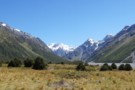
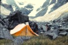
At Veil Stream
Photograph
•
Distance: 5.8km away
the havelock valley finally starts to narrow down
More ▶︎
Eric Bivvy
Hut
•
Basic Hut/Bivvy (Canterbury Mountaineering Club).
•
Distance: 8.1km away
A tidy historical shelter located on Agony Island near St Winifred Hut. Currently, the hut is great for shelter especially ...
More ▶︎
McCoy Hut
Hut
•
Standard Hut (DOC). Capacity: 6.
•
Distance: 8.6km away
McCoy hut is a six bunk hut located on the confluence of Franceis River and McCoy Stream, which flows down ...
More ▶︎
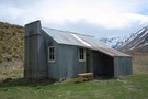
St Winifreds Hut
Hut
•
Standard Hut (Canterbury Mountaineering Club). Capacity: 9.
•
Distance: 8.8km away
Iron hut owned by the Canterbury Mountaineering Club. The hut was built in 1959 to replace the old Havelock Hut. ...
More ▶︎
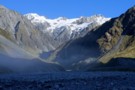
View from St Winifreds Hut
Photograph
•
Distance: 8.9km away
The mountains around the upper havelock river from the front of st winifred's hut.
More ▶︎
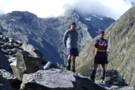
Bettison Stream & Dennistoun Pass Feb 2011
Photograph
•
Distance: 9.6km away
This pic taken by Neil B with my camera shows two old crusties above the bush line on the Bettison ...
More ▶︎
Bettison Stream
Photograph
•
Distance: 9.6km away
Campsite in the upper Bettison 1969 /70. Very little in the way of maps or information then. Came over the ...
More ▶︎